Queensland braces for category 5 Cyclone Yasi- Experts comment
by Jeni Bone on 2 Feb 2011
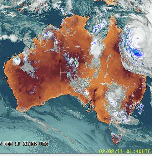
Tropical Cyclone Yasi Bureau of Meteorology
http://www.bom.gov.au
As Queensland braces for one of the most powerful cyclones in our history - equal in force to a nuclear bomb according to some forecasters and the same category 5 as Cyclone Katrina which devastated New Orleans in 2005 - weather and environmental experts comment on various aspects of the cyclone and its probable consequences.
Destined to hit Queensland's coast around 9pm (EST) tonight between Townsville and Innisfail, Cyclone Yasi is 10 times the size of Cyclone Tracy in 1974. Around a category 3-4 cyclone, Tracy killed 71 people, caused $837 million in damage and destroyed more than 70 percent of Darwin's buildings, including 80 percent of houses.
Professor Nick Harvey is Executive Dean of the Faculty of Humanities and Social Sciences at Adelaide University. He is an expert on coastal processes. He says the danger lies in the storm surges that accompany a cyclone of this magnitude.
'The generation of storm surges with tropical cyclones relates to a number of factors such as the drop in pressure (creates an upward bulge in water in the middle of the storm of up to one metre), the size and intensity of the storm and the speed of forward movement. The forward left quadrant of the storm (in the southern hemisphere) is the most dangerous because this is where the forward movement and the clockwise spiral of gale force winds pile up water ahead of the storm. There is often a forerunner effect, generally of less than a metre, which travels ahead of the storm.
'The storm surge can also be amplified by the funnelling effect of the coastline depending on its configuration. Notable storm surges in north Queensland have occurred in 1899 at Bathurst Bay, with dubious reports of a 12.2 m surge when many lives were lost from a pearling fleet, and Cyclone Althea in 1971 which produced a 3.6 m surge north of Townsville. There is concern that the storm surge with Tropical Cyclone Yasi could arrive at the same time as the high tide either this evening or tomorrow morning when the tide will be over 3m in Townsville.'
The expert on the relationship between El Niño/La Niña and cyclones is Professor Neville Nicholls, an ARC Professorial Fellow in the School of Geography and Environmental Science at Monash University, Victoria. He is also President of the Australian Meteorological and Oceanographic Society. He says the relationship of strong La Niña events to active tropical cyclone seasons is the basis for predictions issued by the Bureau of Meteorology several months ago, of an active season for 2010/11. 'However, the relationship does not help us in predicting the occurrence of an individual cyclone, nor of its likely intensity.'
More at http://www.bom.gov.au/climate/ahead/tc.shtml.
Professor Jonathan Nott from the Australasian Palaeohazards Research Unit at James Cook University is an expert in the long term records of natural hazards and is currently in Cairns. Prof Nott says Yasi is likely to be 'the biggest one that anyone living today has seen in Queensland'.
'This is looking like the most intense and largest cyclone that we’ve had since 1918 for the east coast of Queensland. In that year we had two very intense systems cross the Queensland coast, one through Innisfail and one through Mackay. We haven’t had anything comparable since then until Yasi.'
Prof Nott points out the attribute that sets Cyclone Yasi aside is its large diameter.
'We commonly get ‘midgets’ in Queensland – small diameter but still intense tropical cyclones. From time to time we get one of these very, very large ones but the midgets have been more common in recent years. It makes it more unusual for us again to see a large diameter system here.
'It’s going to cause storm tides to go through people’s houses. We can expect some areas to be really badly impacted by the storm tide. Larry didn’t come through at high tide; it came through on a lower tide. It wasn’t as intense as this system and it wasn’t as large either. It didn’t get any storm tide into houses but this one most certainly will. I think it will show people just how dangerous it is to live so low relative to sea level and so close to the beach.'
Prof Nott continues: 'We’ve been lulled into a false sense of security in Queensland because we’ve been through a fairly quiet time of cyclones since the 1970s. We haven’t planned properly, put it that way. It’s going to shake people up and I hope get the planners and decisions makers to revise their approach to planning for this sort of thing.'
At James Cook University in Townsville, Cam Leitch is Manager of the Cyclone Testing Station and he says the local houses and buildings will bear the brunt of the cyclone's impact and some will emerge in better shape than others.
'There will be a range of buildings ages and types affected. Regulations changed back in the late 70s-early 80s partly because of Cyclone Tracy. The post-80s houses are built to higher standards and designed for bigger wind forces in cyclonic regions.
'Some will be stronger than others by the laws of probability. These newer houses are designed for a mid-Category 4 cyclone – 250km/h wind. At that wind speed with all things going well, houses shouldn’t fail.'
On the negative side, he continues, older houses could see much more damage.
'The wind pressurising inside the building pushes up on the roof. The suction on the roof and the wind outside pushing in gives you a double whammy. The two effects combined together can produce a failure. Quite often flying debris breaks a big window on a house and the wind comes rushing in. This extra oomph of pressure plus the pressure in the house and the suction on the roof causes the roof to pop and a failure occurs.'
Professor Mark Bradford is the Research Director at the Centre for Infrastructure, Engineering and Safety in the Faculty of Engineering at the University of New South Wales. He says that if wind speeds reach the predicted 300 km/hr, there will be considerable damage.
'Buildings built prior to 2002 were required to withstand up to 250 km/hr for this Cyclone Region C area of Australia. These were determined from historical data, and it was noted in drafting the new 2002 wind code that the incidence of Category 5 cyclones has increased in recent years.
'For many, if not all residential and industrial buildings, the wind loading is the critical load that the structure will experience and these structures would be very vulnerable. Severe storm surges are also predicted, with the water having at least the potential for destruction as experienced in Queensland a couple of weeks ago.'
As for rebuilding after the event, Prof Bradford says infrastructure will be the first priority.
'Roads, airports, hospitals, shops etc are important. Design wind load would have to be reassessed as these high wind speeds may become more common-place in years to come, with even 300 km/hr winds needing to be designed against. Lessons can be learned from Hurricane Katrina (also a Category 5).'
Source: Australian Science Media Centre
If you want to link to this article then please use this URL: www.sail-world.com/79917