The Mother of all Tropical Cyclones!!
by Bureau of Meteorology/Marine Business News on 2 Feb 2011
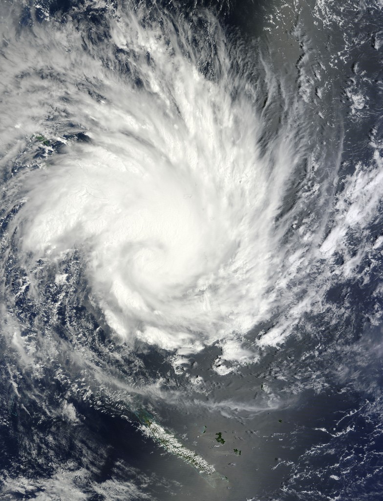
Tropical Cyclone Yasi expected to hit Queensland coast Wednesday night - Image NASA NASA/Goddard Space Flight Center Scientific Visual
Severe Tropical Cyclone Yasi was upgraded to category five off north Queensland this morning as the weather bureau warned it was likely to be 'more life-threatening' than any storm seen in Australia in living memory.
A Tropical Cyclone warning is current for island and coastal areas from Cape Melville and Sarina, extending inland to Croydon and Hughenden.
'We are facing a storm of catastrophic proportions in a highly populated area. You've heard all of the statistics and what it all adds up to is a very, very frightening time for people and their families' said Queensland Premier Anna Bligh
'There's still potential for it to become stronger ... as a strong category five we could see wind gusts in excess of 320 kilometres an hour, which is just horrific' says Forecaster Gordon Banks
The weather bureau says Cyclone Yasi is a large and very powerful tropical cyclone and poses an 'extremely serious threat' to life and property within the warning area, especially between Port Douglas and Townsville.
'This impact is likely to be more life-threatening than any experienced during recent generations,' the Bureau of Meteorology (BOM) said this morning.
Premier Anna Bligh says Cyclone Yasi is the most catastrophic system to hit Queensland.
'Whether it's cyclonic devastating winds, storm surge, or torrential rain further west as a result of this, we are facing an extreme event that will not be over in 24 hours, but will possibly take several days before the full flooding effect is felt across the region as well, potentially right through to Mount Isa,' she said.
'We are facing a storm of catastrophic proportions in a highly populated area. You've heard all of the statistics and what it all adds up to is a very, very frightening time for people and their families.
'This is not something that passes over the coast and is over in an hour.
'This is 24 hours of quite terrifying winds, anywhere up to 300 kilometres per hour, torrential rain, likely loss of electricity and mobile communications, so people really need to be preparing themselves mentally as much as anything else.'
The bureau says the low category five cyclone will continue to move in a west-southwesterly direction during today, but could become a high category five before making landfall.
Senior bureau forecaster Gordon Banks says it could take at least 24 hours for Cyclone Yasi to weaken after it makes landfall.
'There's still potential for it to become stronger ... as a strong category five we could see wind gusts in excess of 320 kilometres an hour, which is just horrific.'
He added: 'If you're bunkering down in the regions it's going to be quite frightening and it's going to go on and on for quite some time.'
A Cyclone WATCH is current for coastal areas from the remaining tropical interior east of Camooweal and north of Winton.
At 4:00 am EST Severe Tropical Cyclone Yasi, Category 5 was estimated to be 650 kilometres east northeast of Cairns and 650 kilometres northeast of Townsville moving west southwest at 30 kilometres per hour.
Severe TC Yasi is a large and very powerful tropical cyclone and poses an extremely serious threat to life and property within the warning area, especially between Port Douglas and Townsville.
This impact is likely to be more life threatening than any experienced during previous generations.
The Cyclone has now reached Category 5 and will continue to move in a west-southwesterly direction during today.
Coastal residents within the warning, and particularly between Port Douglas and Townsville are specifically warned of an extremely dangerous sea level rise [i.e. storm tide] as the cyclone approaches and crosses the coast. The sea is likely to steadily rise up to a level which will be very dangerously above the normal tide, with extremely damaging waves, strong currents and flooding of low-lying areas extending some way inland. People living in areas likely to be affected by this flooding should take measures to protect their property as much as possible, and be prepared to follow instructions regarding evacuation of the area if advised to do so by authorities.
Damaging winds with gusts to 90 km/hr are expected to develop on coastal islands later this morning, then extend onto the coast during the day, and further inland across the northern tropical interior overnight.
Between Cooktown and Ingham these winds will become destructive with gusts in excess of 125km/hr during the afternoon and very destructive with gusts above 280 km/hr between Port Douglas and Cardwell during the evening as the cyclone approaches. These very destructive winds can also occur on the seaward side of hills to the north of the cyclone and are also forecast to reach the Atherton Tablelands.
Flooding rains will develop from Cooktown to Sarina during the afternoon and then extend inland overnight.
People between Cape Melville and Sarina, extending inland to Croydon and Hughenden should complete preparations quickly and be prepared to shelter in a safe place.
- Boats and outside property should be secured.
- For cyclone preparedness and safety advice, visit Queensland's Disaster
Management Services website [www.disaster.qld.gov.au]
- For emergency assistance call the Queensland State Emergency Service [SES] on
132 500 [for assistance with storm damage, rising flood water, fallen trees on
buildings or roof damage].
People about the remaining tropical interior east of Camooweal and north of
Winton should consider what action they will need to take if the cyclone threat
increases.
- Information is available from your local government
- For cyclone preparedness and safety advice, visit Queensland's Disaster
Management Services website [www.disaster.qld.gov.au]
- For emergency assistance call the Queensland State Emergency Service [SES] on
132 500 [for assistance with storm damage, rising flood water, fallen trees on
buildings or roof damage].
Details of Severe Tropical Cyclone Yasi at 4:00 am EST:
Centre located near...... 15.7 degrees South 151.7 degrees East
Location accuracy........ within 20 kilometres
Recent movement.......... towards the west southwest at 30 kilometres per hour
Wind gusts near centre... 295 kilometres per hour
Severity category........ 5
Central pressure......... 924 hectoPascals
Patrick Quirk from Maritime Safety Queensland says commercial shipping and recreational boat users have been well warned over the past week and should know to stay away from Cyclone Yasi.
He says he hopes no-one at sea is foolish enough to get too close to the system moving rapidly across the Coral Sea.
'There were some pictures going around comparing this to Larry, but this is a system which is almost beyond belief,' he said.
'It's almost beyond description in the extent of the system and also the power of the system. It's almost a perfect storm.'
Please ensure that neighbours have heard and understood this message, particularly new arrivals or those who may not fully understand English.
The next advice will be issued by 8:00 am EST Wednesday 02 February.
This warning is also available through TV and Radio Broadcasts; the Bureau's website at www.bom.gov.au or call 1300 659 212. The Bureau and the State Emergency Service would appreciate this warning being broadcast regularly.
If you want to link to this article then please use this URL: www.sail-world.com/79896