Marine Parks Authority new zoning for Jervis Bay and Solitary Islands
by Penny Robins on 27 Jan 2011
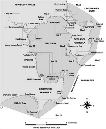
Jervis Bay Marine Park Map - http://www.mpa.nsw.gov.au/ NSW Maritime
http://www.maritime.nsw.gov.au
Marine Parks Authority today announced new and improved zoning plans for New South Wales Jervis Bay Marine Park and Solitary Islands Marine Park to begin on 1 March.
New zoning plan finalised for Solitary Islands Marine Park
Under the new zoning plan, marine habitats will be better protected, prawn trawling will continue in a reduced area of the park and recreational fishing access will be improved at three key spots.
The MPA has also announced a new zoning plan for Jervis Bay Marine Park, on the State’s south coast and the completion of the Lord Howe Island Marine Park zoning plan review.
More than 80 per cent of all marine parks will still be outside the sanctuary zones and remain available for recreational fishing.
Director General of the Department of Environment Climate Change and Water (DECCW) and MPA Member, Lisa Corbyn, said the new zoning plans were developed in response to new research findings, the outcomes of the 2009 zoning plan review and more recent community input on the draft zoning plan.
'Zoning reviews are required under the Marine Parks Act, initially after five years and then at ten year intervals,' Ms Corbyn said.
'They provide an opportunity to consider new information, including feedback on how the park is operating, and to determine whether conservation and sustainable use objectives for each park are being met.
'As a result, there have been substantial changes to zone boundaries in Solitary Islands Marine Park, minor changes at Jervis Bay and no changes at all to the Lord Howe Island Marine Park Zoning Plan.
'The changes only relate to zones and activities within the marine parks – there are no changes to park boundaries.'
Ms Corbyn said consultation on the draft zoning plan for Solitary Island Marine Park was extensive, with 42 stakeholder meetings and information days attended by over 350 people. A total of 6,519 submissions were received during the three month period.
'The MPA has listened to marine park users and, following consultation with stakeholders and the local advisory committee, changes have been made to the consultation draft zoning plan in response to community feedback, local experience and the best-available science,' she said.
'Estuary sanctuary zones will remain unchanged, and access to ocean beaches for recreational fishing will be improved under the new zoning plan.
'In response to concerns about proposals in the draft to remove all commercial trawling from the park within two years, the new zoning plan allows trawling to remain in a key corridor near North Solitary Island and key whiting grounds closer to shore.
'The cultural significance of the park to the Gumbaynggirr people has been further recognised with three new Aboriginal Special Purpose Zones.'
Ms Corbyn said the new zoning plan will be supported by a $150,000 tourism and marketing campaign focussed on the Wooli and Minnie Water local areas .
The campaign will be developed collaboratively with Clarence Valley Council, local businesses and tourism stakeholders over the coming months and implemented in the lead up to next summer.
Industry & investment NSW will administer a $1.5 million voluntary commercial fishery buy-out program funded by the Environmental Trust to offset reduced access for prawn trawling and trap and line commercial fishing and avoid increased fishing pressure on areas that remain open within and outside the park.
Ms Corbyn said the range and extent of research conducted in the Solitary Islands Marine Park, particularly since 2004, underpins the zoning changes and is available on the MPA website.
'This research, some of which has been recently published in the scientific literature, has involved seabed habitat mapping, biodiversity assessments, targeted studies on key fish species, assessments of pests and disease, and cultural, social and economic studies,' she said.
'New seabed mapping techniques helped discover new and very valuable seabed habitats in the deeper parts of the park – habitats which have now been included in new sanctuary zones.
New zoning plan finalised for Jervis Bay Marine Park
Under the new zoning plan for Jervis Bay Marine Park, ocean based sanctuary zones will be adjusted to better protect intermediate reef habitats. Commercial trawling will no longer occur at Wreck Bay or Crookhaven Bight and lift netting activities will be prohibited in Jervis Bay..
About 80 per cent of the marine park, including key sites such as Middle Ground, Longnose Point, Crocodile Head and Moes Rock, will remain available for recreational fishing.
New zoning plans have also been finalised for Solitary Islands Marine Park, on the State’s North Coast and Lord Howe Island Marine Park.
Director General of the Department of Environment Climate Change and Water and MPA member, Lisa Corbyn, said the new zoning plans were developed in response to new research findings, the outcomes of the zoning plan review in 2009 and detailed community consultation on the draft zoning plan in 2010.
'Zoning reviews are required under the Marine Parks Act, initially after five years and then at ten year intervals,' Ms Corbyn said.
'They provide an opportunity to consider new information, including feedback on how the marine park is operating, so we can make sure conservation and sustainable use objectives for each park are being met.'
'The changes relate to the zones and activities within the marine park only – there are no changes to the park boundaries.'
Ms Corbyn said community consultation on the draft zoning plan for Jervis Bay Marine Park had been extensive, with 35 stakeholder meetings and community information days held. A total of 3,064 submissions were received during the three month consultation period.
'We’ve listened to marine park users and made changes to the draft zoning plan in response to submissions, Advisory Committee advice, local experience and the best available science.
'The total area of sanctuary zones in the marine park will remain largely unchanged, However the Point Perpendicular–Crocodile Head sanctuary zone will be relocated to increase representation of intermediate reef habitats in sanctuary zones from 8 to 14 per cent of their total known area.
'These reefs are in water 20 to 60 metres deep and are often dominated by sponges and other invertebrates and support a wide range of fish species.
'In response to submissions received from the community and fishing groups, the Brooks Rock–Moes Rock Sanctuary Zone proposed in the draft zoning plan will not proceed, instead the new Beecroft Peninsula sanctuary zone will replace two other sanctuary zones.
'Also in response to community consultation, NSW Maritime will address several boating issues that were canvassed in the draft zoning plan.'
Ms Corbyn said research and monitoring conducted in Jervis Bay Marine Park, particularly since 2004, had underpinned the zoning changes. The detail now available on biodiversity, habitats and use of the park has increased markedly since the original zoning plan was developed prior to commencing in 2002.
The research and monitoring program for marine parks will continue to inform the management of marine parks and details are available at www.mpa.nsw.gov.au.
The Environmental Trust will provide funding of up to $400,000 to Industry & Investment NSW to administer a voluntary commercial fishing buy out to avoid commercial fishing pressure increasing elsewhere.
Marine Parks Authority http://www.mpa.nsw.gov.au!here!
If you want to link to this article then please use this URL: www.sail-world.com/79704