Jeppesen Marine poised to unleash C-MAP 4D cartography
by Bob Wonders on 29 Nov 2009
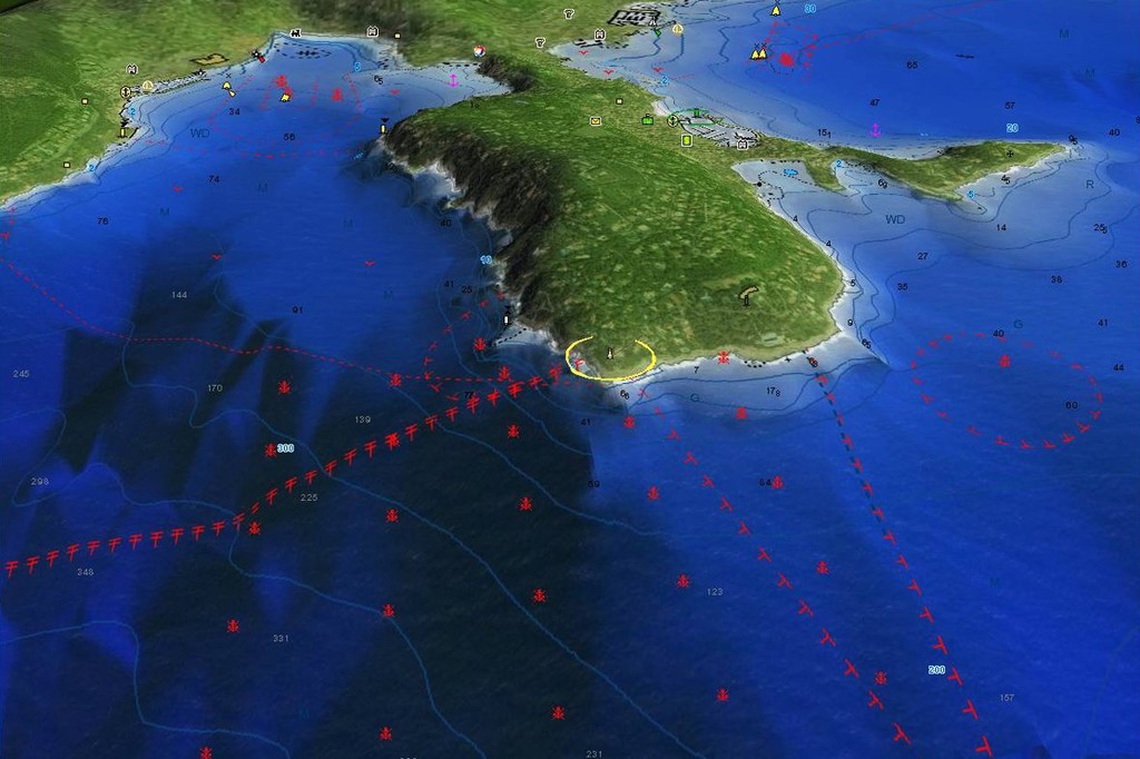
Three-dimensional chart. - Jeppesen Marine story SW
Jeppesen Marine has unveiled its plans to introduce C-MAP 4D, an all-new electronic charting technology that will literally change to way boaters see their world.
Hailed as a ‘revolutionary approach’ to navigation information, C-MAP 4D is make its global debut at US and European boat shows.
It had its US premiere at the renowned Fort Lauderdale International Boat Show.
Wayne Hunter, managing director of Jeppesen Marine Australia, said the new technology offered by C-MAP 4D gave boaters control over their navigation solutions in ways never before possible.
'It really takes navigation to another level,' Mr. Hunter said.
'Using only one cartridge, the coverage area can be selected and the content chosen that meets the specific needs at the time,' he explained.
Users, for example, can select the MAX segment which includes all the popular features of the existing C-MAP MAX product or go to the 4D segment of C-MAP 4D for the advanced feature set.
This amazing technology brings charting into the fourth dimension!
While the physical world may have three dimensions, adding the 4th dimension of time gives navigators the most detailed 3D height and depth worldwide database available and combines this with Jeppesen Marine’s unparalleled professional chart data.
C-MAP 4D is based on a continuous update process to give boaters access to a personalised navigation experience with up to date data ensuring safe navigation.
The technology also enables users to see the ‘real world’ onscreen; C-MAP 4D includes a navigational perspective with high resolution coastal imagery overlaid on the most accurate and up to date vector data, plus thousands of extraordinary photos of the most popular marinas and primary areas of interest.
Easy-Routing technology ensures users will find getting from point-to-point has never been easier.
'This Easy-Routing technology analyses the high-quality C-MAP 4D data, works out the shortest route and then checks and displays hazards that may be encountered on each leg of the journey, it really is amazing,' Mr. Hunter added.
Jeppesen Marine has not overlooked the traditional paper charts, and provides as additional reference source for navigational awareness.
Boaters receive ‘at a glance’ information using the nautical paper charts overlaid on the multi-dimensional shaded relief for a new boating experience.
As with all C-MAP by Jeppesen cartography, C-MAP 4D includes the most up to date navigation information available.
Jeppesen Marine technology experts maintain a constant focus on updating databases, with C-MAP 4D benefiting from this expertise at least twice annually and in some regions as often as three times every year.
'This feature means that boaters can now select how often they want or need to update their charts based on their boating adventures,' Mr. Hunter added.
Beginning the 2009/2010 summer, several leading marine electronics manufacturers will be able to offer C-MAP 4D capabilities.
About Jeppesen Marine:
Jeppesen Marine is a market-leading provider of digital navigation solutions, based on worldwide vector chart data type approved to ISO19379, meteorological information and transmission technologies. Through its wide range of products and services, Jeppesen Marine serves numerous markets from light marine, to today’s safety-conscious commercial shipping industry operating on the inland/coastal waterways as well as high seas. Jeppesen Marine is chartered with the same underlying values that launched Jeppesen in 1934 – improving safety and efficiency through innovative navigation solutions.
For further information, contact Wayne Hunter, Jeppesen Marine, Gladesville, NSW.
If you want to link to this article then please use this URL: www.sail-world.com/63863