Meridien Marinas Airlie Beach RW Day 3 Weather - Another Day in Heaven
by Kenn Batt on 16 Aug 2009
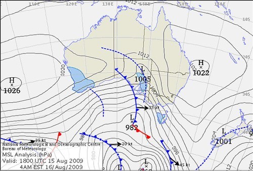
Sunday morning weather Bureau of Meteorology
http://www.bom.gov.au
2009 Meridien Marinas Airlie Beach Race Week Weather Day 3
Nil Warnings current.
Synoptic Discussion:
Today can be again summed up as 'yet another day in paradise'.
The change yesterday was quite shallow and as such the wind speed struggled to get into low double digits as the direction hooked left during the afternoon.
A high pressure system is expected to dominate the race area over the next couple of days. As such the pressure gradient is expected to be quite slack and local winds should prevail. The next change is expected on Tuesday. This is expected to produce a SE wind surge of 15 to 20kn (ave) during the afternoon.
Observations:
At 0630hr surface winds over the Airlie Beach area were out of the SSW averaging around 3-6kn (a mix of land breeze and synoptic wind) and the temperature was around 15-16 deg. At Hamilton Island the wind was NE’ly at 2kn gusting 4kn, (temp 20C, pressure 1019hPa) indicative of the weak synoptic flow.
Forecast Winds for Middle of Pioneer Bay (Read Discussion below)
1000:MD130 DR(110-150) MS06 SR03-11kn could be glass-out?
1200:MD090 DR(070-120) MS08 SR04-13kn could be glass-out?
1400:MD070 DR(050-100) MS10 SR07-14kn chance 350-040deg?
1600:MD050 DR(040-090) MS11 SR08-15kn chance 350-040deg?
1800:MD030 DR(010-070) MS10 SR07-14kn chance 340-030deg?
Note : First column is mean wind direction in deg Magnetic (MD). It is the 10min average (mean) value at a height of 10m above the water leading up to the hour quoted. The second column is the directional range (DR) of the wind direction in deg Mag. This takes into account the natural oscillation of the wind and is a function of the atmospheric stability, etc. The third column is the mean speed (MS) in knots (kn) and is the average 10min value leading up to the hour quoted at a height of 10m above the water. The last column is the wind speed range (SR) in knots and is the lowest wind speed to highest wind speed in the 10min leading up to forecast hour.
Discussion
Will a true sea breeze develop via a glass-out or will the SE’er be pulled left by the sea breeze component during the afternoon? This is the dilemma that we face today?
As you can see above I’m placing slightly greater faith in the 'pulled around SE' scenario BUT there is a good chance that we will go to a true sea breeze via 'glass-out' conditions. Whichever way it goes there won’t be a great deal of pressure today.
Wind will be lighter in lee of any landmass and a little stronger between islands (in channels) and around some headlands.
Natural oscillations today around 15 to 20 deg away from effects of topography, tending around 30 to 50 deg closer to the effects of any land mass.
Weather
Early fog patches then dry. Take plenty of sunscreen and warm clothes in case?
Maximum land temperature at Airlie Beach: 26 degrees. Sea Temperature: about 22 degrees.
Wind Waves:
0.4 to 0.8metres, less in lee of land, more when wind wave opposes tidal current.
(Wave heights quoted are significant wave heights).
Current: . Another good flood this afternoon. Be very careful particularly in the Channels, etc.
Remember: Tide floods to the south and ebbs to the north in the Whitsundays.
Tide at Shute Harbour: High of 2.40 at 0706hr , Low of 0.50m at 1301hr and High of 3.63 at 1953hr.
Outlook
Monday: Early fog patches then dry with W-SW winds 4-8 knots early, shifting E-NE at 8-12 knots during day. A very nice lay day indeed.
Tuesday: Dry with light W-SW at first shifting S-SE at 10-15kn during the morning and increasing to 15-20kn during the afternoon.
If you want to link to this article then please use this URL: www.sail-world.com/60208