Melbourne to Hobart- East versus West
by John Curnow on 23 Dec 2008
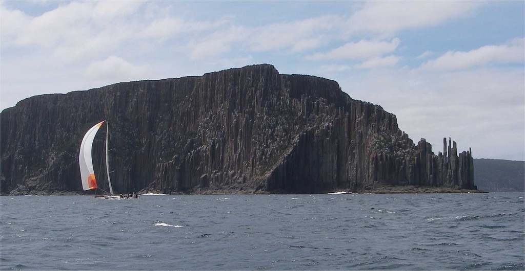
The marvellous Organ Pipes of Tasman Island - M2H John Curnow
On December 27, 2008, some 25 crews will be aiming to answer an interesting question for the very first time. ‘Which is faster?’ The East or West coast of Tasmania? The answer will no doubt come down to planning, navigation and the vagaries of SE Australian Summer weather patterns.
To help understand this and to assist with the planning of your ‘virtual M2H race’, let’s investigate these clear and distinct differences.
Predominantly, the weather at this time of year provides for cool, strong South Westerlies, which can often get violent. On land it might be mild, perhaps even blisteringly hot, but at sea the game is always different. We can all remember the Boxing Day Test being washed out and there was one Christmas in Melbourne in the late Nineties where Lunch was served in 42degrees, only to have cake served in 16!
So it really is a lottery and when you look at the distances and navigation issues, you can see that the challenge between the two will not be over until one has crossed the line ahead of the other.
Thankfully, we all take off together. You’re bouncing off the rev limiter as the ‘Dash for Cash’ to the Heads unfolds. Big Christmas feeds and even bigger Christmas drinks for some, will be all but forgotten in the half hour or so it will take for you to pop your head out into Bass Strait. If you’re an M2H West, you have around 140nm to get to Cape Grim at the top of Tassie (reputably the cleanest air in the world). If it is blowing from the South West, you could be 2 slabs in and the #5 up, before you know it. The next lottery will be more like drawing straws, as you get to see who is going downstairs to prepare dinner!
On the M2H East, you could have a full main and big bag up, howling along past Cape Schanck, on your way to The Prom doing high teens or on a large or lightweight flyer, somewhere in the 20kn plus zone. Please look out for the Anser Group and Hogan Island, however, as you barrel on to the Kent Group and then Flinders Island. You’ll be pretty happy too. Your journey to other side of Bass Strait has only been around 180nm and you may be doing in excess of triple what the M2H West fleet are getting for VMG. Careful when opening the champagne at this time, for extra consideration will reveal that really your journey to the top of Tassie at say Eddystone Point, is more like 260nm and you still have to get around the Sister Islands and face the challenges of Banks Strait, before you can make for St Helens Island. Don’t forget either, that your race is actually 16nm longer than West, as well.
So we are both now at the top of Tasmania and the game is on to get to Hobart. Alas, it could all be so very different if the wind is from the North. M2H West could be aiming to go after Future Shock’s record of 1day 23hr 15min and East may well be in T-Shirts, but nowhere near as far down the track!
Whatever the breeze, M2H West will have to work their way through between Black Pyramid, Albatross Island and South Black Rock. There is a 1.5 to 3kn current here from the SW and it is determined to put you nearer to Hunter Island and the even stronger and more difficult currents that lie there… You’ve got 95nm to cover to get to Cape Sorrell, past Bluff Hill Point and if the weather is kind, Mt Heemskirk (how apt given our Sponsor) and Mt Zeehan at over 700m should be nice landmarks. Low Rocky Point at the top of Port Davey is where the breeze often increases, but in your favour, you are now coming around East and you may get to spring those sheets somewhat. If it is blowing from the West here, you can almost bet it will be from the South on the other coast.
[Sorry, this content could not be displayed]
Over in the M2H East you will have had to decide smartly after Flinders if you are going out to get the EAC and meet the S2H fleet or if you are going the play the vagaries of the coast and work the shorter distances first to Schouten Island, then Maria Island (pronounced like pariah) and finally Tasman Island. Of course the scenery is truly amazing and the Organ Pipes on Tasman Island’s SE corner have been welcoming sailors forever. If the wet weather gear has not been on before, it will be by now. The Westerlies that have been hitting the M2H West fleet curl around the bottom of Tassie and become Southerlies for the M2H East fleet. Your VMG could be woeful and meanwhile M2H West could be finally back to a full main and be getting the spinnaker up for the ride of a lifetime from SW Cape, past Maatsuyker Island and onto The Friars and Bruny Islands, surfing their boats on massive swells that circle the globe in the Southern Ocean and wave to the penguins as they go.
[Sorry, this content could not be displayed]
‘Oh how I remember Bass Strait - the speed, the flat deck and hot meals…’, you’ll lament. That was well and truly then and this is now. If this was a cruise, Demons Cove and Port Arthur are just a pinch further on, but you’re racing and you have to get to Cape Raoul and then march across Storm Bay. Forget the sloping deck and every second wave coming over you. Grunt up, concentrate on trim and steer the waves well.
Over on M2H West, the deck will be mostly flat, the VMG will be accelerating at what will seem like an ever increasing rate and hot food will mysteriously appear like the answers on a CSI TV show. You’ve got some ground to make up. Your scenery will be so very spectacular, but don’t get caught like a roo in the headlights. You can make up a bit of time by ducking through the small, 0.5nm gap in The Friars and you have to watch the wind shadows caused by the hills on The Brunys. Cape Queen Elizabeth is the last major mark before the Iron Pot and who will have got there first you wonder? ‘Helsal II’ or ‘Extasea’ on M2H East or ‘Shortwave’ on M2H West… If it has been on the nose all the way and the crew have hung in, then even ‘Ninety Seven’ from M2H West may pick up those rights.
The Derwent River has never been easy to complete. Some have sailed straight up there on wonderful moonlit nights. Most, however, have tales far more concerning. A few have even cut the corner of the Iron Pot just a little too much and moved the keel half a metre back! There are just 10nm from there to the finish line and the fleet compacts nicely here, with some crews making up plenty of places in this final section. Watch for the Taroona Hole and any other local knowledge elements you may know of.
Most of all, good luck with your actual or virtual race and watch the bets! Zero to hero and back again are likely to happen several times this year…
If you want to link to this article then please use this URL: www.sail-world.com/52116