A Tall Ship Passage with the Eyes of History
by Marrakech News/Lisa Mylchreest on 7 May 2008
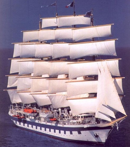
Royal Clipper SW
Eminent environmental historian, writer and public speaker Dr Kent Mountford describes a journey he did on a tall ship 'The Royal Clipper' from Portugal to Morocco, and through the journey relives the life and conditions as they would have been when the tall ships roved the earth as the prime method of long range ocean travel.
Last autumn, flying to Lisbon, Portugal, I watched northerly winds sweep down the Bay of Biscay. These winds were gathering moisture from remnants of the Gulf Stream, which a year earlier had coursed north offshore the Chesapeake, and were now looping back along the west coast of Europe.
These winds and the great circular North Atlantic gyre respond to the Earth rotating beneath any object in motion throughout the Northern Hemisphere. This effect, known as the Coriolis Force-named for physicist Gustave Gaspard Coriolis, who first described it in 1835-deflects water and air masses to the right, and thus eventually, in a circle.
The ships of Portuguese, Spanish, French, Dutch and English explorers were borne by these winds (today's Northeast Trade Winds) down near the equator, where they shifted direction to blow these vessels across the ocean to the New World.
I had taken an opportunity to voyage 3,500 miles across the Atlantic along much of the route
sailed by Capt. John Smith and Adm. Christopher Newport, and was en route to meet my ship,
the Royal Clipper. I had e-mailed the Clipper's master, Capt. Klaus Muller, a mariner with more
than 50 years of experience at sea, and was delighted when he responded that he, too, studied
early English navigation and looked forward to our time together.
The plane flew over the snow-tipped Cordillera Cantabrica of Northern Spain, which stretch 300
miles east-west and rise to 8,688 feet. This was the Iberian stronghold against the Moorish
invasion 1,300 years ago. Today, its western hills are laced with a labyrinth of roads leading to
about a hundred windmills harvesting mountain gales, which supply remote villages with
electricity for the first time in history.
The plane descended over Portugal's coastal plain, across the valley of the great Tagus River
where, at its mouth, lies the ancient port of Lisbon.
The estuary of the Tagus is wide but braided with submerged bars, low islands and shoals as
one progresses upstream. The harbor reaches of Lisbon's port are deep enough for shipping, and
natural currents in the estuary keep the channels clear without dredging.
As my flight circled the old city, I saw my ship, the Royal Clipper, moored along the quay; its
five masts and white paint gleaming in the cool autumn sun.
Minutes later we were delivered to the harbor and walked out on the quay. My eye was drawn
to a replica 15th century caravel, the 85-foot Vera Cruz, from the port of Vila do Conde. She
had been built in 1990 to commemorate the 500th anniversary of the voyages of the Portuguese
explorer Bartholomeu Dias, who in 1488 was the first mariner known to have rounded the
southern tip of Africa, thus opening a 'way to the East.'
I mused on these voyages of discovery as I walked up the gangway of Clipper, the full-rigged
sailing ship that would be my home for two-and-a-half weeks. In my sea chest I carried a board
mounted with three replica navigation instruments from the 15th and 16th centuries-the global
positioning systems of their day: a compass with gnomon that served as a sundial to
approximate noon; a small mariner's astrolabe for assessing the height of celestial bodies; and a
Davis Quadrant or 'backstaff' to measure the noontime altitude of the sun.
These had been built about 40 years ago for an exhibit at the Newark (NJ) Museum by its then
science curator, Kenneth Lynn Gosner, my early mentor. His widow, in presenting them to me,
had cautioned they had been exhibition pieces, never intended for sea duty, but I modified them
to be functional and had done a few preliminary trials taking sun sights on the Chesapeake. The
instruments were probably more prepared for the task ahead than I was. Muller, who had
graciously granted me access to the bridge at any time, also reserved space in a cabinet below the ships' instruments to store my own replicas.
Also moored on the quay was the Holland American Line's Rotterdam and as she departed, I saw how vastly larger she wasfeet, 59,652 tons-to the Clipper's 439 feet, 5,000 tons. Clipper was built equal in size to Preussen, of the German 'P' Line, the largest, successful full-rigged ship built during the age of the sail.
We departed Lisbon at dark, unfurling 30- or 40,000-square-feet of sail, and passed the illuminated Belem Tower. In Dias' time, the harbor entrance was defended by an anchored ship. Decades later, in 1515, the construction of this tower of sculpturally rich Moorish and Portuguese design began and was completed in 1521. Ringed with cannon, it is the ceremonial gateway to Lisbon and is a UNESCO World Heritage Site.
We left the lights of Portugal dimming on the horizon as we ran south toward the northwest coast of Africa.
By sunrise, when I came on deck, we were abeam of Cabo de Sao Vicente, and just over the horizon behind it was Vila de Sagres, near the promontory where Prince Henry the Navigator in 1415 began sending out ships of discovery. There is a Portuguese map of 1424 that suggests some features of the Americas. Did they wander there so early?
The caravel, upon which the Vera Cruz was based, is thought to have been developed at nearby Lagos, near Sagres, about 1441. Christopher Columbus recognized the advantage of this sailing rig and modified one of his ships to carry it on his 1492 voyage. The Portuguese and Spanish had pioneered the route we were sailing and it was well-known for more than a century before The Virginia Company ships came this way.
The Moorish occupation of the Iberian peninsula ended in 1492, but the influence of their cultural and technological advances remained. Columbus may have owed Queen Isabella's authorization of his voyage to the euphoria immediately after expulsion of the Moors from Spain. And, he also almost certainly used an astrolabe of Arabic derivation to find latitude during his voyages to and from the New World.
I took my first noon navigational sights in the great bight of ocean between Europe and Africa. The ship's physician, Dr. Manfred Kraether, who was by my side at the time, said that he had visited a Danish Museum and seen a Davis quadrant. After I showed him how it to use it, he had the steadiest hand of any aboard who tried. My position that day was off from the ship's 'known' position by 37.8 nautical miles, but on the scale of the chart we used to show the whole voyage, our course ran 28.5 and my error was equal to only three-eighths of an inch.
Winds that day, sweeping out from Gibraltar, rose to a moderate gale, gusting to 44 knots-more than 50 mph. These were the strongest we would encounter on our 3,554-nautical-mile voyage, and rain spit at us into the gray dusk. Third mate Oleg Petrovsky later told me that two of our older staysails had been blown out, and the steel chain sheets which controlled them had broken. The sailmaker spent many hours rebuilding one of these sails using a huge sewing machine during sunny mornings on deck.
Muller explained that on average here in November, a large high pressure system with clockwise winds sits over Europe while a corresponding low with anti-clockwise winds lies over northern Africa. These two circulations combine to cause strong winds to pour out from the Straits of Gibraltar. While they were good sailing winds for a ship of Clipper's size, they would have created impossible conditions for any 15th and 16th century ships blown out from these straits trying to return into the Mediterranean Sea.
By dawn the next morning, we
If you want to link to this article then please use this URL: www.sail-world.com/44166