Cruising on the Columbian coastline
by Nancy Knudsen on 5 Mar 2007
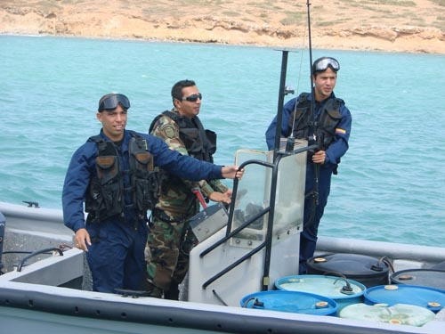
Columbian Coastguard BW Media
Having left Bonaire in the Dutch Antilles on what was to be hopefully a four-day sail to Cartagena in Colombia, the weather forecast for the area ahead of us turned pretty foul. In addition to a forecast of 30-35 knots (and we know from experience that grib and most other forecasts must have 10 knots added to make them realistic), the worst day of the forecast winds was to put us in the very worst spot on the Colombian coast.
In this area, the west-setting current that pervades in the Caribbean, when it reaches the seas close to Panama, sweeps around to become an east setting current.
This means wind against a couple of knots of current, just when the depths are getting shallower. In addition to this watery conflagration, the Magdalene River empties into the sea there, pouring out vast quantities of fresh brown water from a third direction, along with tons of flotsam – logs, branches and wide areas of growing flotsam.
So we decided to come into this huge bay at Cabo de la Vela for which we had merely a verbal description and a waypoint from a Bonaire live-aboard, and wait for better news. (There are no pilots for the area, and we only have a very small scale chart)
Colombia has been avoided by cruisers passing through because of a widely held belief that the area is dangerous – Colombia is one of the largest drug producers in the world. Not long after we anchored we were approached by a very fast moving fishing boat, three dark clothed men aboard, holding automatic weapons. It was all happening very fast, too fast. This is not looking good, I thought.
The pulled up causing a sudden wash which rocked us all, and the young leader said, ‘Welcome to Colombia, we are the Colombia Coast Guard’.
It turned out that that was just about all the English they guys knew, but the smiles told the story well enough. ‘Europe?’ they asked. ‘No, Australia,’ we said. They looked blank. As they sped away after looking at our passports we could see three 200 hp outboards driving their ‘fishing boat’.
It’s blowing 35 knots and sometimes 40 in the anchorage. The boat’s jarring and leaping around, and it’s very noisy, with the whine of the wind, the banging of the halyards, and rush of the water.
The terrain is just empty low hills and rocky desert, with only a small ragged flag standing straight in the wind to beside the lighthouse to tell that we are in Colombia.
The high winds seem to be causing a high dust factor in the air. Its 10.00am before the sun can get through the haze. Then the wind comes up soon after. The fishermen from a desolate looking village at the end of the bay come around to look at our sailing boat. Some just smile and others ask for Coke and rope and food. We can’t stay here too long or we’ll have nothing left.
We thought of trading goods for fish, but they look so poor, and have so few fish that we just couldn’t do it.
Since sending that report Nancy and Ted have moved further along the Columbian coast, their Petersen 46 Blackwattle is currently off Santa Marta on the Columbia coast at Bahia Gayraca, a Columbian National Park and one of the few areas of coral reef on 700 nautical mile of Colombian coastline. They are heading for Panama.
If you want to link to this article then please use this URL: www.sail-world.com/31526