Irma strike on South Florida Sunday after raking through the Bahamas
by Weather.com on 9 Sep 2017
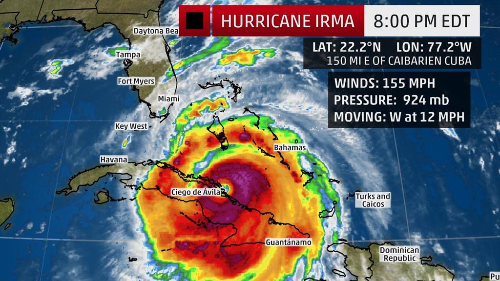
Current Storm Status - The highest cloud tops, corresponding to the most vigorous convection, are shown in the brightest red colors. Clustering, deep convection around the center is a sign of a healthy tropical cyclone. The Weather Channel
Hurricane Irma, a potentially catastrophic Category 4 hurricane, is now hammering parts of the Bahamas and Cuba, and will turn its fury on Florida in what is likely to be the state's strongest hurricane strike since Charley 13 years ago.
(More:
Hurricane Central |
Impacts In Caribbean)
Below is everything we know about Irma right now, including its latest status, along with potential forecast impacts in the U.S. and the Caribbean Islands.
Irma's Latest Status, Timing
The center of Irma is located about 315 miles southeast of Miami, Florida, and is moving west at about 12 mph.
Irma's maximum sustained winds are currently 155 mph, a formidably strong
Category 4 hurricane, based on data from an Air Force Hurricane Hunter aircraft.
(More:
Irma's Notable Extremes)
Hurricane warnings have been issued for Florida's Sebastian Inlet southward around the peninsula to Anna Maria Island, the Florida Keys, the central and northwestern Bahamas and the Cuban provinces of Camaguey, Ciego de Avila, Sancti Spiritus and Villa Clara.
A hurricane watch is also in effect for portions of Florida, from north of the Sebastian Inlet to the Flagler and Volusia county line, as well as north of Anna Maria to the Suwannee River, along with the Cuban provinces of Guantanamo, Holguin, Las Tunas and Matanzas.
A storm surge warning has also been issued from Sebastian Inlet to Venice and the Florida Keys. A storm surge watch is in effect from north of Sebastian Inlet to the Flagler/Volusia County Line and on the west coast from north of Venice to the Anclote River including Tampa Bay.
Low wind shear, increased mid-level moisture and increasing oceanic heat content favor that Irma will remain a powerful hurricane (Category 4 or stronger) until landfall in Florida, though some intensity fluctuations are likely at times. At this intensity, small deviations in wind speed will not significantly change impacts. A direct hit will be devastating.
It is possible that Irma could re-attain Category 5 intensity before landfall.
(Interactive MAP: Track Irma)
South Florida will see severe hurricane conditions starting this weekend. Major impacts could then spread through the rest of the Florida Peninsula, Georgia and the Carolinas.
Here's a general overview of the timing for impacts from Irma into next week.
Potential Impact Timing
• Bahamas: Friday-this weekend arriving from east to west; hurricane-force winds should spread into the northwest Bahamas by Saturday; slow improvement in the southeast Bahamas by Saturday
• Cuba: Now through Saturday; conditions improving Sunday
• Florida: Saturday-Sunday, lingering into early Monday in north Florida; hurricane-force winds may arrive in South Florida and the Florida Keys by Saturday night
• Georgia-Carolinas: Late Sunday-Monday
U.S. Forecast: Destructive Impacts Possible in Florida, Georgia and the Carolinas
Recent trends in computer models and resulting forecast from the National Hurricane Center suggest Irma will now track a bit farther west. This does not reduce the threat to eastern Florida, but it could drastically increase the threat to the west coast of Florida if this trend continues.
According to the latest National Hurricane Center's forecast, the center of Irma will be very close to South Florida by early Sunday morning, with conditions going downhill already during the day on Saturday.
(Latest News: 650,000 Ordered to Flee Miami-Dade in County's Largest Evacuation Ever)
The following life-threatening water-level rises (storm surge) are possible in South Florida Sunday, according to the National Hurricane Center, if they occur at high tide:
• Southwestern Florida from Captive to Cape Sable: 8 to 12 feet
• Cape Sable to Boca Raton, including the Florida Keys: 5 to 10 feet
• Ponce Inlet to Jupiter Inlet: 3 to 6 feet
• Venice to Captiva Island: 5 to 8 feet
• Tampa Bay and from the Anclote River to Venice: 3 to 5 feet
These numbers could rise, especially on the west coast, if Irma makes landfall farther west in Florida or stays in the Gulf of Mexico.
The National Hurricane Center is issuing a potential storm surge flooding map that can be found here.
If you are told to evacuate a coastal location, please do so as instructed or you could be in extreme danger.
Irma's wind field is large. Hurricane-force winds extend outward up to 70 miles from the center, and tropical-storm-force winds extend outward up to 185 miles. These winds will expand eastward across the entire peninsula.
Depending on the exact track of Irma, locations in the hurricane warning in central and southern Florida could see devastating to catastrophic impacts, including structural damage and widespread power and communication outages from high winds. The National Weather Service said that areas in the hurricane warning could be uninhabitable for weeks or months.
After that, Irma's center is increasingly expected to track up the Florida peninsula Sunday into Monday, then into Georgia Monday night into Tuesday.
Significant inland wind damage and rainfall flooding could occur in parts of central and north Florida, Georgia and the Carolinas, as well.
A forecast model developed by Seth Guikema (University of Michigan), Steven Quiring (Ohio State University) and Brent McRoberts (Texas A&M) predicted 2 to 3 million customers could be without power from Florida to east Tennessee from Irma's widespread winds.
Dangerous surf and coastal flooding will likely exist throughout the southeastern U.S. coastline even well away from Irma's center this weekend into early next week. The magnitude of any storm-surge inundation along the rest of the Southeast coast will depend on the exact track of Irma.
The National Weather Service in Charleston, South Carolina, says that major coastal flooding is possible along parts of the Georgia and South Carolina coasts Sunday and Monday at times of high tide.
All residents in the Florida Peninsula, Georgia and the Carolinas should monitor the progress of Irma closely.
For more detailed information on possible impacts in Florida, Georgia and the Carolinas, click here.
Forecast: Cuba, Bahamas
Irma's center will likely track between the Bahamas and Cuba through Saturday, likely maintaining at least Category 4 intensity.
(More: Beware 'I' Hurricanes)
To read in full and to keep an eye on the weather.
If you want to link to this article then please use this URL: www.sail-world.com/157116