Cyclone Warning- Marcia heads for Queensland coast
by Sail-World.com on 19 Feb 2015
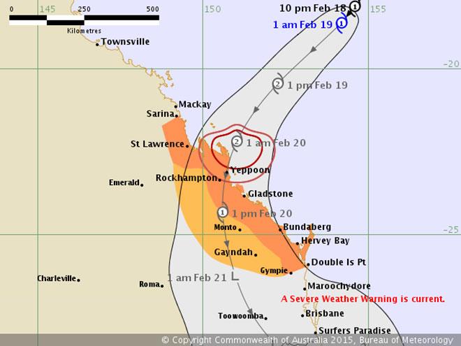
Tropical Cyclone Marcia Commonwealth of Australia
Great Barrier Reef Offshore Waters Forecast: Bowen to Yeppoon
Headline:
Tropical Cyclone Marcia is expected to strengthen and cross the Capricorn coast in the next 24 hours.
Areas Affected:
Warning Zone
Mackay to Double Island Point.
Watch Zone
Adjacent inland areas from St Lawrence to Double Island Point.
Cancelled Zone
None.
Details of Tropical Cyclone Marcia at 4:00 am EST:
Intensity: Category 1, sustained winds near the centre of 75 kilometres per hour with wind gusts to 100 kilometres per hour.
Location: within 55 kilometres of 19.1 degrees South 153.1 degrees East, estimated to be 510 kilometres north northeast of Yeppoon and 650 kilometres north of Bundaberg.
Movement: southwest at 32 kilometres per hour.
Tropical Cyclone Marcia is moving quickly through the Coral Sea towards the Queensland coast. The recent movement has been to the southwest, and it is expected to maintain this general motion through to landfall on the eastern Queensland coast between St Lawrence and Bundaberg early on Friday. Tropical Cyclone Marcia is expected to slowly intensify, with the possibility of reaching category 2 intensity by landfall.
A separate Severe Weather Warning is current for areas south of Double Island Point and west to the Great Dividing
Gales are expected to develop about coastal and island communities between Mackay and Double Island Point late this afternoon or evening. Destructive wind gusts to 150 km/hr may develop about the coast and islands near the centre of Tropical Cyclone Marcia on Friday morning.
Heavy rainfall will develop about coastal and island communities between Mackay and Double Island Point today, particularly over areas to the south of the system. A Flood Watch is current for the area.
Abnormally high tides will be experienced today and Friday with water levels expected to rise above the highest tide of the year on the high tide.
Coastal residents between St Lawrence and Double Island Point are specifically warned of the dangerous storm tide as the cyclone crosses the coast. The sea is likely to rise steadily up to a level well above the normal tide, with damaging waves and flooding of some low-lying areas close to the shoreline. People living in areas likely to be affected by this flooding should take measures to protect their property as much as possible and be prepared to follow instructions regarding evacuation of the area if advised to do so by the authorities.
Dangerous surf is expected to develop about exposed beaches south of Sandy Cape from this morning.
Recommended Action:
People between Mackay and Double Island Point should take precautions and listen to the next advice at 8 am.
Marine Weather Situation
A slow moving high near New Zealand will maintain a firm ridge over southern Queensland coast during the forecast period. A monsoon trough extends from tropical cyclone Lam to a tropical low in the Coral Sea that is expected to move towards the Capricornia or Wide Bay coast on Friday. A trough extending to the south of the low will approach the southern Queensland coast during Thursday and Friday. Forecasts are highly dependent on the development and movement of the low in the Coral Sea.
Tropical System Location
At 10:00 am EST a Tropical Low was located about 495 nautical miles northeast of Mackay and 560 nautical miles north northeast of Bundaberg. Centre located near 16.2S 156.1E. Recent movement has been towards the south at 6 knots.
Forecast for Wednesday 18 February until midnight
Winds: S to SE 20 to 30 knots.
Seas: 2.5 to 3.0 metres.
Swell: SE 1.5 to 2 metres in the Capricorn Channel.
Weather: Scattered showers.
Forecast for Thursday 19 February
Winds: Clockwise 20 to 30 knots. Up to 40 knots possible depending on movement and development of Tropical Low.
Seas: 2.5 to 3 metres, possibly exceeding 4 metres depending on movement and development of Tropical Low.
Swell: SE 1.5 to 2 metres in the Capricorn Channel.
Weather: Rain, heavy at times and isolated thunderstorms.
Forecast for Friday 20 February
Winds: Clockwise 20 to 30 knots. Up to 40 knots possible depending on movement and development of Tropical Low. Winds easing to 20 to 25 knots by late afternoon.
Seas: 2.5 to 3 metres, possibly exceeding 4 metres depending on movement and development of Tropical Low.
Swell: SE 1.5 to 2 metres in the Capricorn Channel.
Weather: Rain, heavy at times and isolated thunderstorms.
Forecast for Saturday 21 February
Winds: N to NW 15 to 20 knots.
Seas: 1.7 metres.
Swell: SE 1.5 to 2 metres in the Capricorn Channel.
Weather: Scattered showers and isolated thunderstorms.
.
If you want to link to this article then please use this URL: www.sail-world.com/131677