Charts and lights blamed for historic yacht sinking in Northland
by Imran Ali, Northn Advocate on 31 Jan 2015
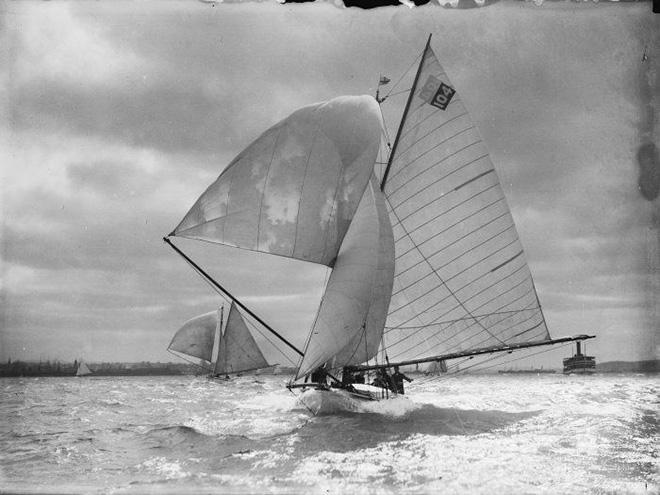
The historic yacht Celox in its heyday. NLNZ
http://mp.natlib.govt.nz/detail/?id=13842
An experienced boatie who was rescued off the Northland coast after his yacht struck rocks and sank has blamed poor navigation charts and lights that failed to identify hazards at sea.
Coromandel sailor David Stemson was sailing to the Cavalii Islands on board his historic yacht Celox about 11pm on Saturday when it hit rocks at the northern end of Motukawaiti Island, about 4km offshore from Matauri Bay, and began taking in water. He was alone on the mullet boat which was built in the early 1900s by Archibald Logan and his brothers Robert and John.
Mr Stemson rang the Fire Service from his cellphone before his message was relayed to police search and rescue and the Whangaroa Coastguard. He climbed up the sails to make the emergency call and waited at the sunken yacht from where he was picked up by a Whangaroa Coastguard vessel about 1.30am yesterday.
Mr Stemson was given dry clothes and hot drinks before he slept at Whangaroa Coastguard crew member Adrian Bosch's home. He was back at the site around noon yesterday, making arrangements to salvage the vessel.
He decided to moor the yacht at Opua since he bought it a few years ago and uses it whenever he comes up north for a holiday.
On Saturday evening, Mr Stemson decided to sail for the Cavalii Islands and drop anchor there for the night.
'The wind was good, there was enough moonlight but the navigation chart is on a very big scale with the whole of Northland peninsula on one page without any inserts,' he said.
'Vital pieces of information about the island's hydrography is missing that would make it easier, both at night and during the day, for anyone and not just sailors to navigate around.'
Mr Stemson said there was a lack of lights around the Bay of Islands and surrounding areas to guide boaties, especially at night.
'I sailed into a minefield of rocks when the navigation chart I had showed a clear passage and I think there has got to be a better resolution map prepared by the hydrographic department that clearly shows the hazards present in different areas. I've been sailing since I was eight but this was the first time I've been trapped in a minefield of rocks and it'll be a hell of a struggle to get the boat up,' he said. Mr Stemson said once the yacht was salvaged, hopefully today, he would arrange for repairs over the next couple of days.
He took part in the Tall Ships race in the Bay of Islands about three weeks ago. Coastguard spokeswoman Georgie Smith commended Mr Stemson for doing everything right when his vessel hit the rocks.
'He had safety gear on, put on his lifejacket and rang 111 so he did all the right things,' she said.
Northland Regional Council harbour master Jim Lyle was not aware of the incident but said generally any vessel that hit rocks already became a navigational hazard.
The onus, he said, was on the owner to recover the vessel and usually the NRC did not take any enforcement action provided there was no environment hazard such as fuel spills from sunken vessels.
For a follow-up story
click here
If you want to link to this article then please use this URL: www.sail-world.com/131209