Cyclone Warning- Port Douglas to Mackay
by Rob Kothe & the Sail-World Team on 29 Jan 2014
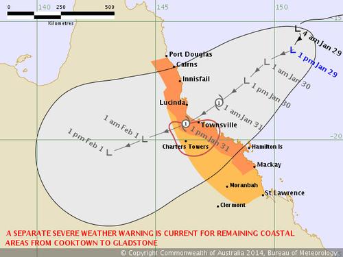
Cyclone Dylan projected path Bureau of Meteorology
http://www.bom.gov.au
Cyclone warning: Emergency preparations are continuing in north Queensland as a potential cyclone, currently a deepening low pressure system approaches the coast.
The system, which will be named Tropical Cyclone Dylan if it continues to develop, is expected to make landfall just north of Townsville on Friday.
There is a cyclone warning for coastal and island communities from Port Douglas to Mackay, with a cyclone watch extending to St Lawrence.
The cyclone threat comes amid king tides that are expected to reach 4.1 metres on Friday, with authorities warning of dangerous storm surges.
TROPICAL CYCLONE ADVICE NUMBER 7 - Issued at 1:27 pm EST on Wednesday 29 January 2014
A Cyclone WARNING remains current for coastal and island communities from Port Douglas to Mackay
A Cyclone WATCH remains current for coastal and island communities from Mackay to St Lawrence, extending inland through the eastern interior north of Clermont.
At 1:00 pm EST a Tropical Low was estimated to be 545 kilometres east of Cairns and 545 kilometres northeast of Townsville and moving south southwest at 11 kilometres per hour towards the coast.
The tropical low is expected to move in a general southwestwards direction over the next couple of days and may develop further as it approaches the Queensland east coast.
A strong ridge of high pressure extends through the Coral Sea to the south of the tropical low. The two systems are currently combining to generate GALES at times along much of the east coast between Port Douglas and Mackay. Winds are expected to increase further with DAMAGING WIND GUSTS to 120km/hr developing about the coast from this evening and extending inland during Thursday and Friday.
Heavy rain, which may lead to flash flooding, is expected to develop about coastal and adjacent inland areas of the North Tropical Coast and Tablelands, Herbert and Lower Burdekin and the Central Coast and Whitsundays districts from tonight and should continue into Thursday.
Coastal residents between Port Douglas and Hamilton Island are specifically warned of the dangerous storm tide as the developing tropical low approaches the coast, particularly on the high tide on Thursday and Friday.
The sea is likely to rise steadily up to a level well above the normal tide, with damaging waves and flooding of some low-lying areas close to the shoreline. People living in areas likely to be affected by this flooding should take measures to protect their property as much as possible and be prepared to follow instructions regarding
evacuation of the area if advised to do so by the authorities.
As the developing tropical low approaches the coast, a storm tide is expected between Hamilton Island and St Lawrence, particularly on the high tide on Thursday and Friday. Large waves may produce minor flooding along the
foreshore. People living in areas likely to be affected by this flooding should take measures to protect their property as much as possible and be prepared to help their neighbours.
A separate Severe Weather Warning is current for remaining coastal and island communities from Cooktown to Port Douglas and from St Lawrence to Gladstone.
This afternoon the CEO of Pantaneius Marine Insurance James McPhail said ' This is a critical area of Queensland coastline. We have already emailed all our clients between Port Douglas and Mackay in the area reminding them them of their need to secure their vessels.'
Details of Tropical Low at 1:00 pm EST:
.Centre located near...... 16.2 degrees South 150.8 degrees East
.Location accuracy........ within 110 kilometres
.Recent movement.......... towards the south southwest at 11 kilometres per hour
.Wind gusts near centre... 85 kilometres per hour
.Severity category........ below cyclone intensity
.Central pressure......... 993 hectoPascals
The next advice will be issued by 5:00 pm EST Wednesday 29 January.
If you want to link to this article then please use this URL: www.sail-world.com/118802