Whatever happened to Sandy Island?
by Nancy Knudsen on 29 Nov 2012
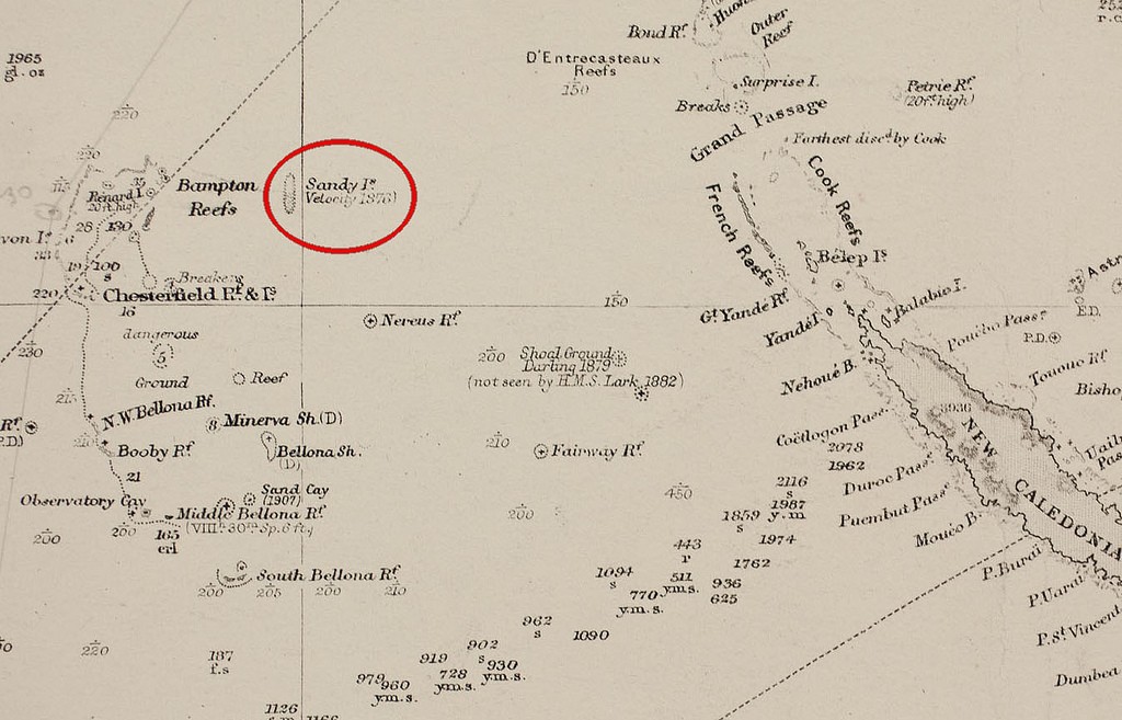
Sandy Island on an old chart SW
Where did Sandy Island go? Captain James Cook is a revered seaman with an unparalleled record of surveying the countries and islands that he visited. He surveyed Sandy Island as between Australia and New Caledonia in the Coral Sea back in 1772. It was also mapped by a British whaler, the Velocity, in 1876. It's been on world charts ever since. But last week, another vessel went to the location and found only deep water.
The island appears on many world maps spanning several hundred years and was supposedly located at 19° 13' 12? S, 159° 55' 48? E. Even Google Maps displayed the island until 26 November 2012, when it was removed.
It was removed because of the reports by some Australian scientists aboard the RV Southern Surveyor who were studying plate tectonics in the area. During the voyage, they noticed a discrepancy between different maps and decided to sail to the supposed location to investigate. The crew found no island and stated their nautical charts showed depths of 1,400 metres (4,600 ft). They found that 'The ocean floor actually didn't ever get shallower than 1,300 meters below the wave base…'
So how could this island, which has been on official charts, not only British, but also German, French, Italian, Japanese, US and Russion charts, have simply disappeared? The short answer, is, of course, that it couldn't.
While no explanation as to why Captain James Cook surveyed an island that is not, and never could have been there, many other islands have also been charted in the past, from such clues as 'a long cloud' or 'breaking waves' indicating the existence of an island. Such islands have been charted, as a precautionary measure, but later found to be non-existent.
What is amazing is that, while the island persisted on charts until this month, this is not the first time that Sandy Island was proclaimed not to exist.
In 2000 a group of radio amateurs headed to the Chesterfield Islands on a so-called DXpedition, hoping to find the remotest dry land possible from which to send a ham radio message.
In order for the Chesterfields to qualify, they scoured its surroundings for land, found Sandy Island on the map, but not where it should be in the ocean. Nobody took much notice of them.
The original report of their expedition does mention that Sandy Island is marked on some maps, but not on others, and quotes a Senior Editor of National Geographic Maps as saying that their cartography is 'hopelessly outdated for this area', and would be updated ‘soon’.
Just in case there are any adventurous cruising sailors out there who would like to test the existence or otherwise of Sandy Island for themselves, be warned. The Chesterfield Islands are an uninhabited archipelago in French territorial waters, west of Sandy Island’s supposed location.
They are a collection of about a dozen islets, some still shifting, and numerous reefs, spread out over an area 75 by 45 miles, but totalling less than 6 sq miles in dry land, and thought to be charted vicariously. These are significant hazards for the cruising sailor, and very likely to be inaccurately charted.
If you want to link to this article then please use this URL: www.sail-world.com/104250