The “Game Changer” for Weather Routing: Automatic Wave Routing
by PredictWind 18 Aug 2022 23:09 PDT

Wave Routing - Boat Motion © PredictWind
PredictWind's newest feature - Automatic Wave Routing allows users to see highly detailed wave data and how their vessel will perform in all wave conditions, along their route.
Weather Routing algorithms typically use wind and current only to calculate the fastest or safest route. However, the biggest factor for comfort and safety is the wave conditions. While the PredictWind weather router has always had the ability to input a manual wave polar, this functionality was rarely used. For most sailors, it's simply too hard to predict their boat's performance in all possible wave conditions.
We've made creating a wave polar for a vessel quick and simple. Using the boat's characteristics (beam, waterline length, displacement and draught) we create a hydrodynamic model of the vessel in all possible sea conditions. This data is then factored into the Weather Routing and Departure Planning tools, giving a more accurate and informative routing output to deliver a safer and more comfortable route.
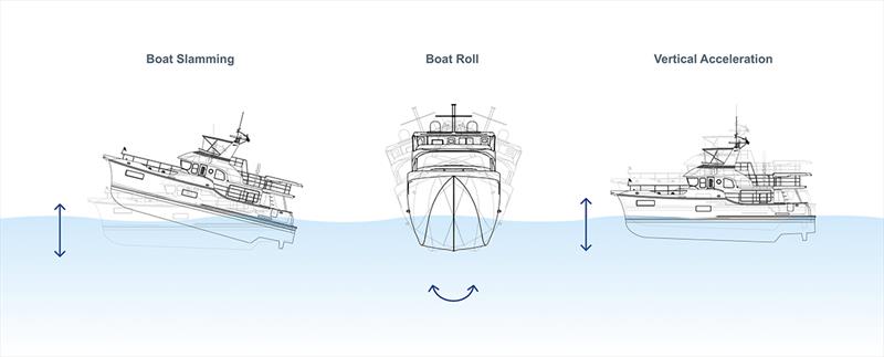
Now that we know the boat's motion characteristics in all possible sea conditions, the boat's roll, vertical acceleration and slamming incidence can now be calculated. These important safety characteristics can be plotted to know exactly how rough it will be for the crew. A vast amount of modelling data is used to calculate these safety metrics, including wind wave and primary, secondary and tertiary swell. Normally this data simply cannot be downloaded on-board due to the large data size, but as the routing is processed in the PredictWind cloud there are no data constraints.
Users now have access to the following boat motion data:
Roll
Roll is the root-mean-square roll amplitude in degrees. When roll motions are large, moving around the boat and performing tasks becomes difficult. Objects not strapped down are likely to move. A roll RMS limit of 4 degrees is often used for safely moving around the boat and completing tasks. Roll tends to be the largest in beam seas. For sailing yachts, which have a heel angle, roll is the change in heel angle due to the waves.
Vertical Acceleration
Vertical acceleration is the root-mean-square vertical acceleration in G force. Vertical acceleration is a good indicator of the potential for the crew to get seasick. The higher the acceleration, the more likely the crew will get seasick. A vertical acceleration limit of 0.2g is often used for safely performing tasks and avoiding seasickness.
Slamming Incidence
Slamming incidence is the likelihood of experiencing at least one boat slamming event per minute. For power and sail monohulls, slamming is measured 10% aft of the bow at the waterline. When this part of the boat emerges clear of the water and then impacts the water with a high relative vertical velocity, it is called a slamming event. For sailing catamarans, slamming is measured at the cross-deck structure and again is based on relative vertical velocity. For either monohulls or catamarans, a slamming incidence of 50% is considered excessive and may lead to hull damage or injuries to the crew.
This data is available in both the Departure Planning and Weather Routing tools. For Departure Planning, customers can use the wave data to ?nd the best time to depart that suits their boat and crew's safety parameters. With Weather Routing, customers can use the wave data to either slow their boat to avoid adverse conditions or plot a course around areas with an unsafe sea state.
Automatic Wave Routing opens up a whole new world of detailed data, giving users confidence to make the right decisions for a safe and comfortable trip.