Please select your home edition
Edition
PredictWind DataHub Promo V1 1456 x 180 TOP

Predictwind - Images of Hurricane Matthew's trajectory - 1

by Sail-World.com on 6 Oct 2016
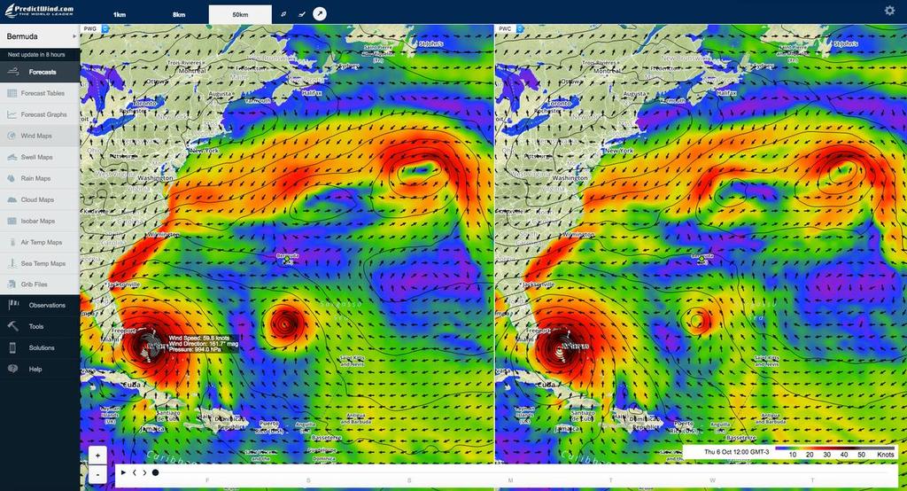
Hurricane Matthew - Florida - current strength and location at 3.00pm local time in Florida on October 6 PredictWind
Hurricane Matthew has wrecked havoc in the Caribbean and Haiti in particular.

In these images from Predictwind's wind mapping facility we can see the path and shape of the of the hurricane as it moves towards a landing point on the US coast just north of Miami and then moves along the US coast before coming to a stop around Jacksonville.

Using a feature of the wind map we can see in the latest projection that winds are averaging just under 60kts (70mph/110kph) at the peak of the hurricane. Gusts would be expected to exceed that by 15-20% or more. Wind gusts in Haiti exceeded 150mph/130kts). The latest image was taken at at 3.00pm local time on October 6 in Florida. Note the strongest winds are on the northern/seaward side of the hurricane.

The latest projections have it that the winds will ease gradually as the hurricane moves along the US coast and is projected to be at a peak of 37.5kts in Jacksonville, where it is expected to peter out.

Of slight concern is a second depression circling Bermuda, currently it is expected to only have winds of 22-25kts as it passes over Bermuda in a few days. However at 2.00pm Thursday Oct 6, Tropical Storm Nicole was upgraded to a grade 1 hurricane and renamed Hurricane Nicole. Although Nicole is not expected to land in USA, Bermuda is in its cone, or estimated area in which Nicole is expected to track. Currently Nicole is 300nm south of Bermuda but is tracking NNW at 6kts towards Bermuda.

The path and intensity of the other storms in the area have significant changes daily.

This chart is a split screen showing the two feeds processed by Predictwind to take account of topography and other factors. These are wind charts only - other features in Predictwind show swell height (open water) and rainfall. Higher than normal tides are often a feature of deep depressions - which increases the damage caused by the large swells as they come ashore.

At Fort Lauderdale at 9.00pm local time on Oct 6, 2016, the projection from one feed is that winds will average 52kts, with gusts of 60kts. Rainfall is heavy at 6.2mm per hour at that time with 3metre seas. As the hurricane centre passes a wind change will happen around midnight local time.


About Predictwind:

Developed by former Olympian, Jon Bilger (470, 1992), PredictWind application was used by the Swiss team Alinghi to win the 2003 and 2007 America's Cups, and has become the leading wind system used by racing and recreational sailors around the world. It is available on a subscription basis and also with a free forecast option.

A mobile app for Android and iPhone is available and www.predictwind.com!PredictWind is available for download

Real time local wind observations have been added as further functionality.

You can check the weather anywhere in the world, and get a five-day forecast, plus a variety of other features and functions of www.predictwind.com!PredictWind. The app is synchronised with your PC so that your latest set of locations are always available without resetting each time you change a device

PredictWind - Wave Routing 728x90 BOTTOMPredictWind - Routing 728x90 BOTTOMPredictWind DataHub Promo V1 1456 x 180 BOTTOM

Related Articles

PredictWind GPS Tracking Model makes debut
GPS Tracker page is free for all users, connecting to a DataHub unlocks next-level precision New GPS Tracking page blends live vessel tracking, rich journey storytelling, and advanced offshore reliability all-in-one seamless platform.
Posted on 22 Dec 2025
PredictWind AI Forecasting Model makes debut
AI implemented in latest Predictwind model release - forecasting by the hour Predictwind's major Model Release, features PWAi in Beta, AIFS, and ICON, - sets a new standard for global forecasting precision and confidence
Posted on 13 Nov 2025
PredictWind works out your sail changes
New Predictwind feature helps cruisers and racers optimise performance and safety Predictiwnd has introduced a Sail Crossover Charts feature, a cutting-edge tool designed to help sailors make smarter, safer, and more efficient sail changes.
Posted on 25 Aug 2025
PredictWind launches PredictRain
New app From PredictWind delivers hyper-accurate, short-term rain predictions PredictRain is a groundbreaking standalone app that combines advanced AI modelling with intuitive tools to provide timely and precise rain forecasts for all types of outdoor activities.
Posted on 5 Aug 2025
Rolex Fastnet: Steady conditions expected
Competitiors are expected to start in a 12-14kt Westerly and assisted by the easterly tide. Predictwind's metrologist Arnaud Monges expects the Rolex Fastnet Race to get underway in a 12-14kts WSW breeze, with a building current from an easterly direction. Using weather routing we have predicted finish times for the Ultims and AC25 yachts.
Posted on 26 Jul 2025
Admirals' Cup: Predictwind weather supplier
Predictwind champions diversity and empowers Women in Offshore Racing PredictWind, a global leader in marine weather forecasting, is proud to announce its significant involvement in the upcoming Admiral's Cup 2025.
Posted on 17 Jul 2025
PredictWind to show new race tracker in August
The Ocean Race joins with PredictWind as Official Tracking and Weather Services Supplier The Ocean Race, often described as the toughest test of a team in sport and widely recognised as a leader in impactful ocean health initiatives, and PredictWind, a global leader in marine weather forecasting, are collaborating on a new race tracker.
Posted on 4 Jul 2025
Nick Olson on PredictWind's newest features
Nick Olson discusses PredictWind's newest features PredictWind has long been a leader in presenting high-quality marine forecasts. Nick Olson discusses the company's newest features.
Posted on 12 Jun 2025
PredictWind launches Anchor Alert App
The app delivers immediate, real-time alerts if their anchor drags, ensuring enhanced safety. Global leader in marine weather forecasting, PredictWind, has announced the launch of its new standalone Anchor Alert app.
Posted on 12 Jun 2025
New PredictWind GMDSS Extreme Weather Alert
Providing real-time mobile notifications for extreme weather forecasts PredictWind, the world leader in weather forecasting, is excited to announce the launch of Extreme Weather Alerts, providing real-time mobile notifications for all extreme weather forecasts issued by the Global Maritime Distress and Safety System (GMDSS).
Posted on 1 Apr 2025