Navigational charts direct from Google Earth - and it's free
by Paul Higgins/Nancy Knudsen on 29 Nov 2011
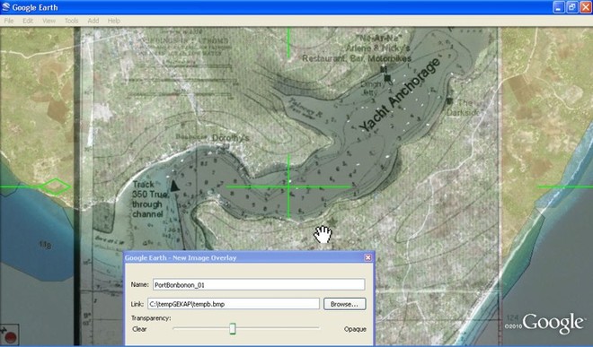
Chart corrected using Google Earth Paul Higgins
If you have ever had a problem with inaccurate charting where you sail, you'll want to know about something that seems so simple in concept that it should have been done years ago, and wasn't - a program that can create navigation charts directly from Google Earth, avoiding any inaccuracy. Retired Canadian HP programmer Paul Higgins tells the story of how he came to create the program, AND explains how to do it, free!
In the fall of 2009 I took a 6 month sabbatical from my Systems programming job at Hewlett Packard and took my sailboat G'DAY II to the Caribbean from Toronto Canada. My sailing buddy was Bill. Our first stop from the Keys in Florida was Cuba. From there we sailed to Isla Mujeres Mexico. While there we heard about about a sailor who had run aground on a reef near Puerto Morelos about 30Km south of Isla. He had been aground for nearly a week and was getting desperate. The sailors at the marina we were in decided to send a few boats with supplies and see if there was anyway to help. I volunteered to go go with another boat.
Bill and I sailed down with the supplies. When we got there I found the Navionics chart on my chart plotter that I was using didn't seem to be correct. The paper chart for the area, 28201 Puerto Morelos also seem to be somehow incorrect. We had to be be very careful we didn't get in the same situation as the boat we came to help.
We tried for nearly a week to get the stranded boat off the reef but finally it was decided to abandon it to the sea. It was starting to breakup from the pounding surf. Just before I left the boat, I noticed that he had the same chart 28201 on his navigation table.
After I returned to Canada I decided to compare chart 28201 with the Google earth. I was shocked to see the difference was over 2nm. I couldn't help wonder if our unlucky friend had been using it when he ran aground. I verified that Google earth was correct because I had kept my track data. I thought wouldn't it be nice to be able to create a chart from Google earth for these areas of the world where the official chart was not correct.
I then discovered that Google earth had an interface that allowed programs to access it. So I wrote a simple program that allowed you to display an area on Google earth and push one button to create a chart. GE2KAP was born.
Since that time GE2KAP has been enhanced many times from requests from sailors around the world. First we enhanced it so you could overlay an official chart on the Google earth display and have both the GE picture and the chart. Then I allowed you to recreate an incorrect chart by aligning a bad chart with GE and extracting the datum correction for a corrected chart.
The interface and messages have been translated into 4 languages so far: French, Spanish, German as well as English. The new version has help files in both English and French.
I am sixty seven years old and now retired. I sometimes sail with my dog Whitey a Chihuahua, Jack Russell mix who thinks he owns the world. I still love programming and computers. It keeps my mind active.
......................
Now, Here is the program that will convert a Google earth picture directly to a BSB/KAP chart without you having to enter any calibration data. I get the necessary calibration data directly from Google earth using its ActiveX API.
This comes in very handy creating charts where the official charts are not great or don't exist. (I will leave it up to you on how to interpret the Google earth license.)
It only supports Windows operating systems: XP, Vista and Win7.
Download the program from my website: www.gdayii.ca and unzip to a directory on your system.
Install the prereqs: :
1. This program is written in REXX programming language and uses the oorexx interpreter.
The lastest version of oorexx can be down loaded from:
http://www.oorexx.org/download.html!Open_Object_Rexx
Please install V4.0.1 or higher: ooRexx4.0.1.i586.exe (32bit).
Note: Install the 32bit version even if you are on a 64bit system.
2. You must have Google earth V5.1 or higher which can be download from:
http://www.google.com/earth/download/ge/agree.html!Download_Google_Earth
Start GE2KAP by double clicking on it from Windows explorer. Then click the Help button and read the instructions on setting up Google earth. Be sure you turn off 'Terrain' as it can cause GE2KAP to create inaccurate charts.
After Google earth is setup, display an area on the earth that you would like to create a chart for.
On GE2KAP enter the location where you want to put the chart and the name of it then press 'Create Chart'.
Voila, the chart is created.
Go to your navigation program and do whatever is necessary to recognize the new chart.
For OpenCPN:
- Open the Toolbox ... Charts .. Add the directory where the new chart is if its not there already.
- Click 'Force Full Database Rebuild' then press OK.
- You should now see chart created at the correct latitude and longitude
If you run into any problems or errors, send me the GE2KAP.log. My email address is in the Help under 'Problems'.
We began by saying that the program is free. It is. But if you're happy with it Paul's dog Whitey would appreciate a donation to keep him in dog food (Just like Wikipedia). To see more, http://www.gdayii.ca/!click_here.
..................
Did you like this article? If you are not a Sail-World subscriber already, did you know that you can keep up with all the news from the world of the cruising sailor with a weekly news hit? It's totally free, as all our income is from the advertisers.
Once you subscribe, all the non-racing news comes to you in one easy to read news magazine, right to your inbox. AND it's up to date, so you don't have to wait for the end of the month to find out what's going on. You can even subscribe a friend. http://www.sail-world.com/Cruising/international/newsletter_subscribe.cfm!Click_here_now!
If you want to link to this article then please use this URL: www.sail-world.com/91281