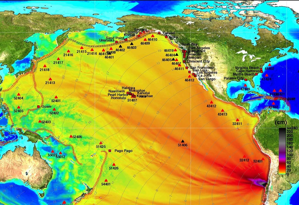
Tsunami Event - February 27, 2010 Chile - the Tsunami forecast model
by Sail-World.com & Powerboat-world.com from NOAA inf on 28 Feb 2010

Chile Earthquake Tsunami model NOAA .
http://www.noaanews.noaa.gov/
NOAA-PMEL-Center for Tsunami Research developed a tsunami forecast model.
The Chile tsunami was generated by the 2010 Chile earthquake which occurred off the coast of the Maule Region of Chile, on February 27, 2010, at 03:34 local time (06:34 UTC), rating a magnitude of 8.8 on the moment magnitude scale and lasting for about three minutes.
It was the strongest earthquake affecting Chile since the magnitude 9.5 1960 Valdivia earthquake (the most energetic earthquake ever recorded worldwide), and is the strongest earthquake worldwide since the 2004 Indian Ocean earthquake.
It is tied with a 1906 Ecuadorian earthquake as the seventh strongest earthquake ever recorded, and far more forceful than the 7.0 Mw 2010 Haiti Earthquake.[10]
In approximately 3 hours, the tsunami was first recorded at DART® buoy 32412.
Forecast results shown below were created with the NOAA forecast method using MOST model with the tsunami source inferred from DART® data. The tsunami waves first arrived at Valparaiso, Chile (approximately 330 km northeast from earthquake epicenter ) earlier than other tide gages, at 0708UTC, about 34 minutes after the earthquake.
The graphics to the left display forecast results, showing qualitative and quantitative information about the tsunami, including tsunami wave interaction with ocean floor bathymetric features, and neighboring coastlines.
The earthquake occurred along the boundary between the Nazca Plate and the South American Plate. At the location of this earthquake, the plates converge at 80 mm/year. The earthquake is characterized by a thrust-faulting focal mechanism, caused by the subduction of the Nazca plate beneath the South American plate.
The coastal part of Chile has a history of great megathrust earthquakes originating from this plate boundary, such as the 1960 Valdivia earthquake. More recently, this plate boundary ruptured at the 2007 Antofagasta earthquake.
The segment of the fault zone that ruptured in this earthquake was estimated to be 400 miles long, and immediately to the north of the 600-mile-long segment that ruptured in the 1960 earthquake.
If you want to link to this article then please use this URL: www.sail-world.com/66879