'Active Captain' - a Review by Tom Lochhaas
by Sail-World Cruising on 6 Jul 2011
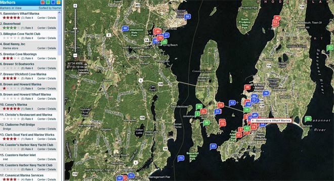
Active Captain showing Newport Rhode Island area SW
Tom Lochhaas of about.com.sailing here writes a review of 'Active Captain' a website that covers a range of valuable information that your electronic charting system does not provide:
Of all the websites and apps providing cruising sailors and boaters with information about marinas, anchorages, and local features, ActiveCaptain is the best.
All information is easily searchable and integrated with NOAA charts as well as street maps and satellite views to make trip planning easy on your computer or on your iPhone or iPad once underway. With over 100,000 boaters writing reviews and updating information, ActiveCaptain provides the most accurate and current data to make your cruising life easier and happier.
Pros:
1. Best online information and independent reviews of marinas and anchorages
2. User-friendly, intuitive design makes it easy to find desired information
3. Online searches are fast, with seamless zooming and scrolling of charts and maps
4. Instantly updated information - always accurate and current
5. Much better information than other online sites such as Marinas.com and Marinalife.com
Cons:
1. Some areas have light coverage and need more user reviews
2. Less data than printed cruising guides for some anchorages and for facilities and attractions ashore
Description:
*The Guidebook screen for any given location shows icons for information available for immediate access
*Extensive information about marinas, anchorages, navigation, and hazards
*Includes growing numbers of locales in Canada, the Caribbean, and other international areas
*Data integrated in apps for smart devices and in popular navigation software for use underway
*Website includes additional articles on cruising topics, such as use of mobile devices for navigation
*Free registration provides newsletters on key cruising topics, such as protecting yourself against the risks of open wi-fi
Guide Review:
Cruising used to involve elaborate advance research and stocking the boat with expensive heaps of cruising guides providing information that was often already outdated upon publication.
Just as chartplotters and electronic navigation over the last two decades replaced navigation by dead reckoning and the need to carry hundreds of expensive charts (except now as an essential backup), online resources have begun to replace printed cruising guides for essential information about marinas, anchorages, and other data needed by cruising boaters. In only a short time, ActiveCaptain has become the best online source of this information.
The Interactive Cruising Guidebook is the heart and soul of ActiveCaptain. You locate your area of interest via base charts or maps or by a location name search. The chart/map/satellite view then shows information available according to color-coded markers for marinas, anchorages, local knowledge, and hazards - showing all or just those you choose. Just click for the details in pop-up windows.
Marina and anchorage descriptions include both the essential data boaters need and user reviews and ratings that provide substantial additional information. Local knowledge and hazards information comes from multiple sources, including NOAA Coast Pilots, current Local Notices to Mariners, and boaters familiar with the area. Although this extensive database doesn't (yet) provide as much information about isolated areas and things to do ashore as in popular print guidebooks, it does provide virtually everything a boater needs for both advance planning and last-minute decisions while underway.
The real strength behind ActiveCaptain is the participation of tens of thousands of boaters who take the time to submit reviews and update locale information. This 'crowd-sourced' data is verified by both the administrators and other boaters, who offer corrections when needed.
While reviews do include some personal opinion, the sheer numbers of reviewers for most locations result in trustworthy information. Captain registration is free and offers benefits and free products for those who earn points by submitting reviews and updates - but the quality of the reviews suggests most captains share their knowledge from a love of cruising more than these incentives.
Originally available only online, ActiveCaptain has been integrated into apps for the iPhone and iPad that are downloaded and provide the data even when offline while boating. With the Charts & Tides app, for instance, you can navigate in real-time on your iPhone and access the ActiveCaptain data directly from your live chart view.
ActiveCaptain is similarly integrated in the MaxSea TimeZero & Coastal Explorer navigational software packages for those using a PC. Together, ActiveCaptain and its navigational partners are changing the way many boaters find their way around the water.
ActiveCaptain's Interactive Cruising Guidebook has become a valuable resource for changing chart data such as buoys that have been moved, shoaling in formerly navigable water, etc. Information that can be very difficult to access in the Coast Guard's Local Notices to Mariners can be seen overlaid on the NOAA chart with an icon that brings up the detail.
A yellow Hazards icon differentiates this info from other types, such as marinas, anchorages, etc. Boat captains can also add their own notes and comments on navigational hazards. This is a terrific free resource for those cruising unfamiliar waters.
As I am starting a sailing cruise into Downeast Maine, I checked ActiveCaptain and discovered a particular channel I transited a decade ago is now choked by lobster pots. Since the boat I'm on has an unprotected prop and spade rudder, I think I'll follow the suggestions of the captains who recommend an alternate route through that area. This is a good example of online 'crowdsourcing' at its best.
If you sail but don't yet know ActiveCaptain, well, you should!
You can follow Tom Lochhaas and his other articles by going to his www.about.com.sailing!website
........................
We at Sail-World also asked Jeffrey and Karen Siegel, the creators of Active Captain, the relative strength in different countries, and here is what Jeffrey told us:
'ActiveCaptain has worldwide support. We're obviously very strong in North America (US, Canada, Caribbean, especially). We've been working hard on European support recently. Chersoft just released a Windows product with every UK chart and complete offline support for our data (Nuno Navigator). That will help get more interest in UK data. We're pretty strong in the Netherlands. Our data is building everywhere - we even have an anchorage in the Antarctic!
Our model has been developed over 5 years now. It works. European data is about where the US data was in 2008. With the 14 navigation products that support us now, 6 more coming, and major manufacturers working on integrating our data into their chartplotters, the future only looks to have more ActiveCaptain in it.'
So we can only encourage all sailors to look at your own area and see if you can add the intimate knowledge that local sailors have to assist the visiting sailor.
You'll find Active Captain at www.activecaptain.com , and don't forget that registering is FREE.
If you want to link to this article then please use this URL: www.sail-world.com/85547