Meridien Marinas Airlie Beach Race Week Day 2 Weather - Early Glass?
by Kenn Batt on 14 Aug 2010
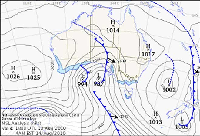
Synoptic-Chart-MMABRW-Day-2 Bureau of Meteorology
http://www.bom.gov.au
Meridien Marinas Airlie Beach Race Week - Here is this morning's forecast by meterologist Kenn Batt for Day 2 of the 21st annual regatta.
Nil Warnings current.
Synoptic Discussion:
It was a great day in paradise yesterday, but I still can’t explain the 'glassout' with that synoptic situation? Such are the vagaries of weather! A shame about the wind today! But at least the rest of the weather will be nice.
A weak high pressure area will dominate the region today.
Observations:
At 0630hr surface winds over the Airlie Beach area were out of the W at around 2-4kn (land breeze) and the temperature was around 11 deg. At Hamilton Island the wind was S’ly at 05kn gusting 06kn, (temp 17C, pressure 1016hPa) indicative of the weak synoptic flow plus a land breeze component.
Forecast Winds for Middle of Pioneer Bay (Read Discussion below)
1000:MD200 DR(230-160) MS05 SR00-09kn possible glassout?
1200:MD090 DR(130-070) MS06 SR00-10kn possible glassy conditions?
1400:MD050 DR(090-070) MS08 SR04-12kn
1600:MD030 DR(010-060) MS08 SR04-12kn
1800:MD080 DR(050-100) MS06 SR02-10kn
Note : First column is mean wind direction in deg Magnetic (MD). It is the 10min average (mean) value at a height of 10m above the water leading up to the hour quoted. The second column is the directional range (DR) of the wind direction in deg Mag. This takes into account the natural oscillation of the wind and is a function of the atmospheric stability, etc. The third column is the mean speed (MS) in knots (kn) and is the average 10min value leading up to the hour quoted at a height of 10m above the water. The last column is the wind speed range (SR) in knots and is the lowest wind speed to highest wind speed in the 10min leading up to forecast hour.
Discussion
The 900m (gradient wind) at the time of constructing this forecast was light and variable, with a light SE to E tendency. It’s forecast to stay that way for racing today. This setup should see some sort of onshore flow, weak sea breeze, over the course today. All the higher resolution models that count, are punting on a land breeze giving way to a light SE’er which is expected to trend left, probably via a glassout, to around about 010deg in and close to Pioneer Bay(this is due to orientation of the Bay). Over other parts of the course, say in the Whitsunday Passage area, the wind direction will range from 030-130deg at similar speeds to those forecast above for Pioneer Bay.
Unfortunately with the land temperature not expected to get much higher than the sea temp then the flow should be weak and very patchy??
I would expect to see a 'glassout' this morning?
Wind will be lighter in the lee of any landmass and a little stronger between islands (in channels and passages) and around some headlands.
Natural oscillations today around 15 to 30 deg away from effects of topography, tending around 30 to 50 deg closer to the effects of any land mass.
Weather
Dry and mostly sunny. Take some warm clothes in case?
Maximum land temperature at Airlie Beach: 22 degrees.
Sea Temperature: 21-22 degrees.
Wind Waves:
0.2 to 0.6metres, less in lee of land, more when wind wave opposes tidal current.
(Wave heights quoted are significant wave heights).
Current: A good flood this morning, followed by a good ebb this afternoon. Be very careful particularly in the passages, channels, close to islands, etc.
Remember: Tide floods to the south and ebbs to the north in the Whitsundays.
Tide at Shute Harbour: Low of 0.46m at 0738hr , High of 3.01m at 1401hr and Low of 0.92m at 2000hr.
Outlook
Sunday: Dry with W 4/6 knots, tending NW to NE 8/14 knots in the afternoon.
If you want to link to this article then please use this URL: www.sail-world.com/73309