Final Day Hamilton Isl.Weather from North Sails
by Kenn Batt on 30 Aug 2008
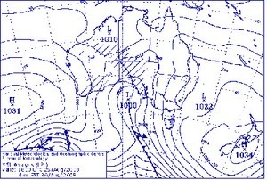
Latest surface weather map SW
2008 Audi Hamilton Island Race Week forecast, courtesy of North Sails.
Yesterday: It was cloudy but warm thankfully. The wind hung in around the 145 to 120deg slot with the speed in the 11 to 14kn range. I’d like to take the opportunity to thank Adrienne Cahalan for her extremely valuable observational input during the series. Thanks Adrienne.
Synoptic Discussion:
A 1034hPa high pressure system near New Zealand is moving slowly southeast and will intensify over the weekend. This high will maintain a firm ridge along the east Queensland coast.
For those people sailing away from the Island over the day or so, please check out the latest weather via the BoM web-site. The ridge is expected to persist along the Qld coast for the next few days but as we get into the new week things get a little complex for those heading south in particular. Stay safe.
Observations:
At 0600hr, the surface wind at Hamilton Island Airport was from SSE (150degT) at 13kt, gusting 16kt (temp 19C pressure 1019hPa) indicative of the general synoptic flow, although it does suffer from the effects of topographic forcing at times. At Creal Reef, further off the coast and to SE of Hamilton Island, the wind was ESE’ly (110degT) at 13kn (indicative of true surface wind). Hardy Reef (offshore to the NE) was reporting a wind from 160degT at 10-11kn.
Forecast Discussion:
Forecast confidence level: Above average.
A ridge of high pressure is slowly building over the area generally. The trough and associated low (which prevented the ridge from building faster than it has) have now weakened and moved away from the southern Qld coast. This being the case then the surface winds today should be off in the 12-14kn range. At this stage stronger winds (15-18kn or so) are expected later in the day (but could arrive earlier so stay extra vigilant). A slight sea breeze component may pull the wind direction a little more left very close to mainland mass than forecast for further offshore??
Natural wind oscillations today around 15 to 25 deg away from effects of topography, tending 25 to 60 deg closer to the effects of any land mass.
Expect wind speed to be 3-5kn stronger in channels/passages and around headlands due to localized funneling and direction quite flicky.
Showers can cause short lived localized gusty and erratic winds. (directional changes to 90deg)
Forecast Winds for Hamilton Island Area in open water
0800:MD150 DR(170-130) MS13 SR08-17kn
1000:MD140 DR(160-120) MS13 SR08-17kn
1200:MD130 DR(150-110) MS14 SR09-19kn
1400:MD120 DR(140-100) MS12 SR08-18kn
1600:MD120 DR(140-100) MS15 SR11-20kn
1800:MD130 DR(150-110) MS17 SR12-21kn
Key: First column is mean wind direction in deg Mag (MD). It is the 10min average (mean) value at a height of 10m above the water leading up to the hour quoted. The second cloumn is the directional range (DR) of the wind direction in deg Mag. This takes into account the natural oscillation of the wind and is a function of the atmospheric stability, etc. The third column is the mean speed (MS) in knots (kn) and is the average 10min value leading up to the hour quoted at a height of 10m above the water. The last column is the wind speed range (SR) in knots and is the lowest wind speed to highest wind speed (Gust) in the 10min leading up to forecast hour.
Other Possibilities:
60% chance that wind speed will increase earlier than forecast above this afternoon?
40% chance that direction trends 10-20deg further left than forecast above close to mainland mass?
30% chance that direction flicks right by 20-30deg later this afternoon?
[Sorry, this content could not be displayed]
Weather
Cloudy with the chance of a shower or two. Take plenty of sunscreen and warm clothing.
Maximum land temperature at Hamilton Island: 22 degrees
Sea Temperature: 19-20 degrees
Wind Waves: 0.5 to 1.5 metre. Less near land, more when wind wave opposes tidal stream.
(Wave heights quoted are Significant wave heights).
Current: A good flood and ebb tide today. Care in the channels particularly.
Tide floods to the south and ebbs to the north in the Whitsundays.
Tide (Shute Harbour): Low of 0.39 at 0422hr, High of 2.92m at 1058hr and Low of 0.22m at 1644hr
If you want to link to this article then please use this URL: www.sail-world.com/48334