Fugawi appoints Oceantalk as distributor
by Media Services on 2 Aug 2007
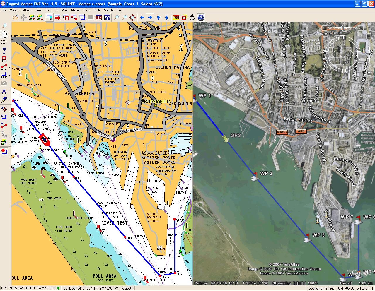
synchronise your Fugawi Map with Google Earth. See your Fugawi GPS location in Google Earth. Oceantalk
www.oceantalk.com.au
Fugawi Software (Northport Systems Inc.) has announced the appointment of Oceantalk PTY Ltd. as the exclusive Australian distributor of its premium marine software products. With the deal becoming effective August 1 2007, Oceantalk will distribute and provide marketing and technical support for Fugawi Marine ENC software to the Australian marine electronics dealer network. Oceantalk will also distribute Fugawi Marine ENC in South East Asia on a non-exclusive basis via its Singapore office.
And the good news for Australian boaties is that Fugawi's impressive range of software will be on display at the Sydney International Boat Show (2-7 August).
'We are very pleased to welcome Oceantalk into our growing international distribution network,' said Robin Martel, president of Northport Systems.
'As the Australian agent for a range of marine products including AIS (automatic identification system) receivers, night vision equipment and solar instruments, as well as its strength with government agencies and technical installers, Oceantalk is well positioned to grow and strengthen the Fugawi brand within the region.'
'We are pleased to be working with Northport Systems, the innovative manufacturer of Fugawi Software,' said Robin Kydd, Managing Director, Oceantalk.
'We believe that Fugawi Software products are set to gain widespread acceptance in the Australian and South East Asian marketplace and that there are strong synergies with our other marine electronics brands.'
Northport Systems Inc. was established in 1995 in Toronto, Canada and now supplies a wide variety of consumer, commercial and military software products for GPS navigation and mapping to over 130 countries: their company slogan is ‘know where you are going.’
Northport's first unique product was the affordable Fugawi brand mapping software for GPS receivers, which allowed customers to scan and calibrate their own map images for use with GPS.
Northport has since expanded both its customer and product base, and now offers a selection of GPS-related software products for land and marine navigation, vehicle tracking, museum displays, and military applications as well as an extensive line of digital maps and charts for regions throughout the world.
Fugawi Marine ENC software has a very important safety feature: it integrates with the AIS or Automatic Identification System.
AIS is a shipboard broadcast system that acts like a transponder and it allows you to precisely identify ships in the area, their location and speed. It looks like a radar display which is overlaid with electronic chart data: the display includes a mark for every significant ship within range that is transmitting AIS signals.
A great deal of international commercial shipping around the globe is bound by government regulations and must transmit AIS signals. Fugawi Marine ENC software allows you to click on a ship’s mark and gather more information about the vessel including a true scale vessel silhouette, the ships name and call sign, vessel dimensions and type.
It tells you your CPA or closest point of approach, which is the distance you will be from the AIS vessel at your closest point. It will also give you your TCPA, or time to closest point of approach, which is when you are going to be at your closest point.
With this information you can make an informed decision about which vessels are a collision threat. The software will tell you how far away the ship is, how long it’s going to take to get to your position and where a ship is likely to go if it is on a curved course.
With this information you can call the ship over the VHF by name rather than the imprecise and potentially ambiguous ‘ship off my port bow’ and take appropriate evasive action. It’s a great feature to have on board any offshore cruising vessel.
As well as the enhanced AIS intergration, the software now offers full compatibility with existing Navionics® Gold+, Gold, Silver and HotMaps® charts (as well as their current support for S-57 and BSB format charts.) This new functionality allows boaters to use a PC at the helm or below deck for planning, navigating and monitoring their passage using the identical, industry-leading cartography that they have installed in their Navionics supported chart plotter.
Ideal for boaters who require ultimate flexibility when planning excursions or during real-time navigation, Fugawi also allows seamless upload and download of routes and waypoints to Navionics compatible chart plotters and handheld GPS receivers, available from Northstar, Raymarine, Humminbird, Garmin, Magellan, Lowrance, Eagle and more.
Offering cutting edge innovation, Fugawi Marine ENC has also recently added support for Google Earth™, via a free Plug-in. The new Plug-in allows boaters to view their current GPS location on geo-referenced Google Earth images next to actual charts in split-screen mode.
This combination of detailed cartography and high-resolution aerial photography provides boaters better visual awareness, enhanced charting information and added peace of mind while boating.
Oceantalk will present the latest Fugawi Marine ENC GPS Navigation Software product, with support for award-winning Navionics cartography as well as Google Earth at the Sydney International Boat Show, August 2-7, 2007.
Oceantalk Contact details
Address : 36/176 South Creek Road,
City : Dee Why
State : NSW
Postcode : 2099
Country : Australia
Phone : + 61 2 9981 9500
Fax : + 61 2 9981 9555
http://www.oceantalk.com.au
If you want to link to this article then please use this URL: www.sail-world.com/36272