Aviva Challenge Shore Team Update
by Mike Broughton on 28 Apr 2006
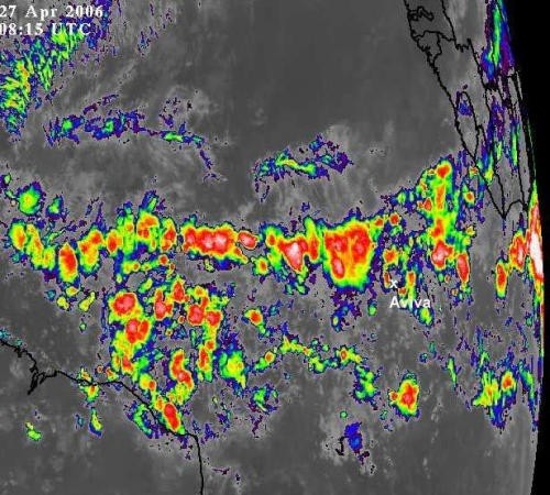
National Oceanic & Atmospheric Administration Image Aviva Ocean Racing
http://www.avivaoceanracing.com
The Doldrums have lived up to their reputation for Dee Caffari. They were looking particularly wide as she approached and as feared the notorious shifting band of equatorial calms have effectively becalmed Aviva just hours after crossing the equator.
It could have been worse. By turning north at around 21° west we have cut the corner a little but it's been a tense wait to see if it was the best option. She was gybing northwest on the approach to the equator and the doldrums narrowed a couple of days ago so we made the move.
The more conventional option would have been to cross the doldrums further west at around 29° west, but this would have required around 700 miles of extra sailing. On her current course she should punch through and progress north in the early hours of Saturday morning, which is much faster than the route further to the west would have allowed.
For now though, Dee is fighting for every mile in a northerly direction in well established Doldrums and has to remain on constant alert for storm clouds which can bring up to 40 knots of wind in minutes. They are a common feature of the region and although they cause a rapid increase in wind speed, which can be tricky to handle, Dee is using them to wriggle her way through the belt of calms.
These clouds extend up to 3 times higher than those found in the UK at this time of year, as the tropopause extends up to 90,000 feet. It is the downdrafts from the edge of these clouds that cause the wind speed to pick up so quickly, so it is easy to see why they are so potent, but the effects are highly localised. However, all wind is favourable when the alternative is creeping north at an average of 2 knots.
There are a few ways to try and locate the storm clouds to try and fast track progress to the trade winds of the North Atlantic. The Quickscat images [NOAA* image attached] are generated by a spectrometer** attached to a normal weather satellite and are very useful. The spectrometer creates a reflection of the dappled effect of wind on the surface of the water and uses it calculate the wind strength at 10 metres above sea level.
We're also looking at a mix of visual and water vapour satellite images along with infrared images. The best at the moment are the infrared images [NOAA image attached], which give a good illustration of the Doldrums at the moment. But Dee is also trying to intercept clouds herself, by using a hand bearing compass, her radar, and of course, the good old 'mark one eyeball', which means that even with all the modern technology the best method can often be using your very own eyes!
* NOAA - National Oceanic & Atmospheric Administration
** A spectrometer is an optical instrument used to measure properties of light over a specific electromagnetic spectrum
INSTRUMENT READINGS - TELEMETRY (LAST REPORT 27/04/06 14h35
SPEED OVER GROUND 6.1 knots
COURSE 325°
APPARENT WIND SPEED 7.8 knots
TRUE WIND SPEED 6.5 knots
TRUE WIND DIRECTION 80°
SEA TEMPERATURE 29.10°C
STATUS (LAST REPORT 27/04/2006 13h08 )
STATUS UNDER WAY
LATITUDE N 1° 41'
LONGTITUDE W 22° 7'
DTF 3 ,122
CMG 325.8
SMG 4.2
24HR RUN 76
24HR SPEED 3.2
DTF - Distance To Finish: Distance from last reported position to the finishing line
CMG - Course Made Good: Course in degrees between the last two reported positions
SMG - Speed Made Good: Speed between the last two reported positions
If you want to link to this article then please use this URL: www.sail-world.com/23396