Cyclone Larry heads for Queensland Coast
by Al Constable on 19 Mar 2006
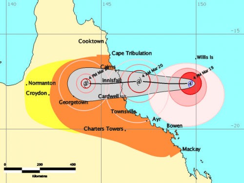
Cyclone Larry 1700 Sunday Bureau of Meteorology
http://www.bom.gov.au
North Queensland's sailing community is battening down the hatches, literally, as the worst cyclone in decades is now approaching the Queensland Coast.
A Tropical Cyclone Warning is now current for Queensland's coastal and island communities from Cape Flattery to Mackay, and extending to inland areas about Georgetown, Greenvale and Charters Towers.
This morning Cyclone Larry was upgraded from a category three to category four and may reach five before it hits the Queensland coastline between Townsville and Cairns.
At Abel Point Marina, at Airlie Beach south of the expected track, Marina Manager Jonathan Crowe reported this afternoon that boats have come in from everywhere.
With extensions to this very large marina not quite completed, boat owners have berthed, at their own risk, in areas of the marina which are not 'signed off' rather than have their boats outside the shelter of the marina.
The fleet of tall ships and major charter vessels which normally moor in Pioneer Bay have come into the marina. They have stripped off all loose objects, removed bimini's and prepared for heavy weather.
Further north, the small coastal town of Carden is directly in the path of the cyclone. Located 1,533 km north of Brisbane, Cardwell's claim to fame is that it is the only town on the Bruce Highway between Townsville and Cairns which is on the coast.
Hinchenbrook Marina at Cardwell is right on the expected track of the cyclone.
This marina is partially protected by Hinchenbrook Island but most local boat owners have not moved their vessels to the marina. Instead many owners are taking their boats well up the channel to find shelter amongst the mangroves.
Adrian Kitchin reports from Townsville that the 350 berth Breakwater Marina, where his Magnetic Palm Island Rent-A-Yacht fleet is berthed was busy all day as preparations were made for what might be the worst cyclone in 30 years.
'We had a lot of trouble convincing clients that they needed to cut short their charter holiday. We've had glorious blues skies and perfect 10-15 knot breezes and the clients just did not understand, until they came back to base and we were able to show them the likely track of the cyclone.'
'We've lowered the booms and removed everything that might possibly come loose, The boats are snug in their berths, triple roped and we have anchors out as well.'
Further north in Cairns Glen Alderton from Counter Disaster and Rescue Service said people on the coast should also prepare for a possible storm surge which could reach two metres above the peak king tide levels.
'People who live in low-lying areas along the beachfront should be making arrangements to stay with some friends who live in a higher place,' he said.
Cairns Regional Harbour master captain Alan Boath expected to issue a 'blue alert' during the day. 'Where large vessels are to proceed to sea, he said. 'Small vessels are taking precautions and making their way to cyclone mooring points.'
TROPICAL CYCLONE ADVICE NUMBER 11
Issued by the Bureau of Meteorology, Brisbane
Issued at 4:51pm on Sunday the 19th of March 2006
A Tropical Cyclone WARNING is now current for coastal and island communities
from Cape Tribulation to Mackay, and extending to inland areas about Croydon,
Greenvale and Charters Towers.
A Tropical Cyclone Watch extends inland to near the Normanton area.
At 4 pm AEST Sunday, Severe Tropical Cyclone Larry, category 4 with central
pressure 935 hectopascals, was centred in the Coral Sea near latitude 17.6 south and longitude 149.7 east, about 390 km east of Innisfail. The cyclone is
expected to intensify further, and move in a general westerly direction at about 25 km/h over the next 24 hours. The centre of Severe Tropical Cyclone Larry is likely to be near the Queensland coast early Monday morning.
Damaging winds with gusts to 120 km/h are expected to develop about the
Whitsunday Islands late this afternoon, and extend to the coast between Cape
Tribulation and Mackay tonight.
Very destructive winds may develop on the coast between Cairns and Bowen on
Monday morning, with maximum wind gusts reaching 280 km/h near the centre of the cyclone.
Coastal residents between Cairns and Townsville are specifically warned of the
dangerous storm tide as the cyclone crosses the coast. The sea is likely to
steadily rise up to a level which will be significantly above the normal tide,
with damaging waves, strong currents and flooding of low-lying areas extending
some way inland. People living in areas should be prepared to evacuate if
advised by authorities.
A preliminary flood warning has been issued for coastal rivers and streams
between Innisfail and Mackay.
Details of Severe Tropical Cyclone Larry, Category 4, for 4 pm AEST Sunday
Central Pressure : 935 Hectopascals
Location of Centre : within 20 kilometres of
latitude 17.6 degrees south
longitude 149.7 degrees east
about 390 kilometres east of Innisfail
Recent Movement : West at 25 kilometres per hour
Destructive winds : out to 120 kilometres from the centre
Maximum wind gusts : 240 kilometres per hour, intensifying
People between Cape Tribulation and Mackay and the adjacent inland should
complete preparations before nightfall, especially the protection of boats and
other property.
If you want to link to this article then please use this URL: www.sail-world.com/22333