Airlie Beach Race Week day 1 weather conditions
by Kenn Batt on 12 Aug 2011
Latest analysis Airlie Beach Race Week media 2012
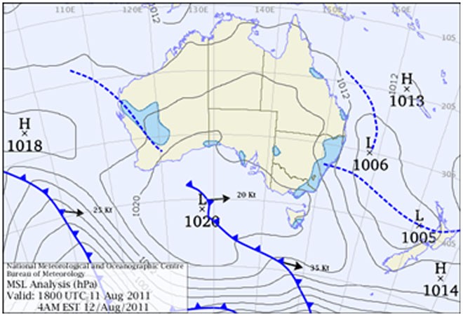
Meridien Marinas Airlie Beach Race Week first day weather report: Synoptic Discussion: A low pressure trough moved through the area last night and is now located well offshore. A ridge of high pressure is expected to develop today in the wake of the trough.
Observations: At 0600hr Hamilton Island was reporting the following conditions: Wind 170deg at 15kn gusting to 18kn, Temp 19C, Pressure 1015hPa).
Forecast Winds for Middle of Pioneer Bay (Read Discussion below)
1000:MD170 DR(190-150) MS15 SR10-20kn, 3-5kn stronger offshore
1200:MD160 DR(180-140) MS14 SR09-19kn, 3-5kn stronger offshore
1400:MD150 DR(170-130) MS13 SR09-18kn, 3-5kn stronger offshore
1600:MD140 DR(160-120) MS12 SR09-18kn, 3-5kn stronger offshore
1800:MD140 DR(160-120) MS12 SR08-17kn, 3-5kn stronger offshore
Note : First column is mean wind direction in deg Magnetic (MD). It is the 10min average (mean) value at a height of 10m above the water leading up to the hour quoted. The second column is the directional range (DR) of the wind direction in deg Mag. This takes into account the natural oscillation of the wind and is a function of the atmospheric stability, etc. The third column is the mean speed (MS) in knots (kn) and is the average 10min value leading up to the hour quoted at a height of 10m above the water. The last column is the wind speed range (SR) in knots and is the lowest wind speed to highest wind speed in the 10min leading up to forecast hour.
Discussion: The forecast gradient wind (900m) for today is 200deg at 20kn
So the big questions are (hopefully answered above??):
1. How far left will the surface direction get?
2. How quickly will the direction turn left?
3. How strong will the winds be?
In this situation we normally experience stronger winds offshore (which includes the Cones and Armit Isles). The sea state should also be higher further offshore than closer to the coast.
Note: Wind will be lighter in the lee of any landmass and stronger and more gusty between islands (in channels and passages) and around some headlands.
Natural oscillations today around 15 to 25 deg away from effects of topography, tending 30 to 50 deg closer to the effects of any land mass.
Weather: Dry. Some smoke around at times? Maximum land temperature at Airlie Beach: about 23 degrees.
Wind Waves: 0.5 to 1.5metres, less in lee of land, more when wind wave opposes tidal current and further offshore depending on fetch. (Wave heights quoted are significant wave heights).
Tide at Shute Harbour: High of 2.72m at 0951hr and Low of 0.37m at 1536hr.
Tidal Stream: A good ebb this afternoon. Be very careful particularly in the passages, channels, close to islands, etc.
Remember: Tide floods to the south and ebbs to the north in the Whitsundays.
Sea Temperature: 20-21 degrees.
Outlook Saturday: Dry. W-SW 4/8 knots at first, tending S-SE 8/14 knots during the late morning and SE-E during the afternoon. Wind speeds are expected to be three to six knots stronger further offshore and also in the Whitsunday and Molle Passages.
Meridien Airlie Beach Race Week
website
If you want to link to this article then please use this URL: www.sail-world.com/87149