ECDIS - cool gizmo for the electronics savvy sailor to pine for
by Nancy Knudsen. on 9 Feb 2011
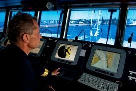
ECDIS - all in one screen SW
Like good electronics? Eat your heart out for the latest cool gizmo, the ECDIS!
Maybe you think you have a good electronic charting system, radar and AIS and an excellent way of getting the weather. Maybe you do, but what if you had them all together in one foolproof system? - It's called the ECDIS, and all you need, apart from perhaps a little more space on the yacht, is money.
Any self respecting sailor with a penchant for good electronics would have to pine for an ECDIS. The Electronic Chart Display and Information System is all things combined so that there's just one single video screen, which can be as wide as a modern home TV screen.
The yacht's course is mapped showing waypoints and buoys, with icons showing approaching vessels and any storm that might be building. An alarm will even tell you about shallow water.
The electronic charts in the system don't have to be corrected or updated, as the system automatically updates cartography and publications, usually through the internet. All navigation systems are automatically integrated - cartography, GPS, radar, AIS and weather, and malfunctions send an immediate alarm. The story goes that you'll never more need the back-up of paper chart or pencil.
They're being seen on megayachts now, and soon - 2012 - they will become compulsory for new yachts over 500gt., and for all ships by 2014.
Once the system is installed and you have the proper charts, then the system is compliant, and once deemed so, no vessel need carry paper charts at all in order to comply with IMO (International Maritime Organisation) rules. This means paperless, integrated systems on all ships, using black box technology, and these systems are already trickling down to superyachts.
No paper? - well, only if you have a second, completely redundant system. And then what happens on a yacht when you are struck by lightning, or suffer a knock-down by a freak wave in the Southern Ocean?
Well, for this sailor, while I am not going to the Southern Ocean any time soon, I will be still carrying paper charts no matter what kind of sophisticated systems I am able to use in the future - 'just in case'.
Definitions:
Electronic Chart Cystem (ECS):
Found on yachts, dinghies and even smart phones, they include standard navigational cartography through companies such as Garmin, Navionics, Maptech and C-Map. They can get their data from private hydrographic sources and may not meet all international requirements for navigational charts.
Electronic Navigational Charts (ENC):
These differ in that they are derived from official hydrographic offices, such as the UK’s Hydrographic Office (British Admiralty). They fulfill SOLAS (International Convention for the Safety of Life at Sea) requirements and may be used as the primary system for navigation. The ENC contain all updated chart information, including notice to mariners, sailing directions and light lists.
Electronic Chart Display and Information System (ECDIS):
This is the navigation information system that allows a vessel to run without paper charts, provided it has adequate updating, back-up arrangements and a vessel positioning system. ECDIS is required to use ENCs and includes route planning, monitoring and positioning, and has appropriate alarms for information display and equipment malfunctions.
If you want to link to this article then please use this URL: www.sail-world.com/80128