Audi Hamilton Island Race Week Weather forecast for Wednesday 25th
by Kenn Batt on 25 Aug 2010
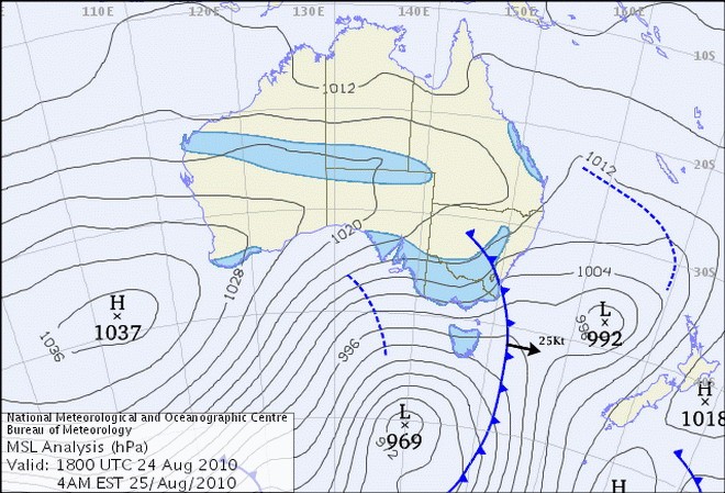
Latest surface chart - Wednesday Audi Hamilton Island Race Week Bureau of Meteorology
http://www.bom.gov.au
2010 Audi Hamilton Island Race Week Weather Forecast for today, Wednesday 25th August.
A new ridge of high pressure is expected to push in over the Whitsundays during today or overnight. The timing of this will be the big issue today? Will we get it or not??
A cloud band lies across southern and central QLD and is producing some patchy light rain areas.
Observations:
At 0600hr the surface wind at Hamilton Island was 200 deg at 3kn, gusting 4kn (temp 21C, pressure 1015hPa) indicative of the weak synoptic wind. Mackay Airport was reporting 170deg at 8kn. At Hardy Reef (further offshore at 19.7S 149.2E) the wind was S at 2kn.
Forecast Winds for Surprise Rock (Read Discussion below)
1000:MD170 DR(190-130) MS08 SR02-14kn
1300:MD130 DR(160-080) MS10 SR04-15kn
1600:MD100 DR(130-040) MS10 SR05-15kn
1900:MD100 DR(130-040) MS08 SR04-12kn
Key: First column is mean wind direction in deg Magnetic (MD). It is the
10min average (mean) value at a height of 10m above the water leading up to the hour quoted. The second column is the directional range (DR) of the wind direction in deg Mag. This takes into account the natural oscillation of the wind and is a function of the atmospheric stability, etc. The third column is the mean speed (MS) in knots (kn) and is the average 10min value leading up to the hour quoted at a height of 10m above the water. The last column is the wind speed range (SR) in knots and is the lowest wind speed to highest wind speed in the 10min leading up to forecast hour.
Discussion
A huge discrepancy between the different models re the timing of the initial S-SE surge?
What a dilemma we face?
The forecast gradient wind is 200deg at 10kn. The actual gradient over the area is unknown as the Mackay observing office hasn’t performed a wind flight since 0900hr yesterday.
Based on the forecast gradient wind, I’ll run with the GFS model, bearing in mind the EC light NW-NE scenario. I’m fairly convinced that any decent wind will occur later this evening or early tomorrow BUT?? Keep your eyes open!
Unfortunately the land/sea temperature gradient is not large enough for any decent sea breeze activity.
Wind expected to be channelled and hence a little stronger between islands and out of some bays e.g. bays along w shore of Whitsunday Island, etc.
Natural oscillations: around 20 to 50 deg
A strong ebb for your racing today, so watch it.
Other Possibilities:
90% chance of light and variable winds with an E tendency till the weak S-SE arrives?
70% chance that you could see 310-350deg at 5-8kn, particularly over western parts ie. Whitsunday Passage
60% chance that wind speeds are 3kn less than forecast?
50% chance that direction hangs in the 160-130deg range for your race period?
30% chance that a S-SE change at 10-20kn arrives after 1500hr?? Some long low cloud should be the visual indicator?
Weather
Some low cloud this morning then dry with the chance of a late shower.
Maximum land temperature at Hamilton Island: 25 degrees.
Sea Temperature: about 22-24 degrees.
Wind Waves:
0.3 to 0.8metres, less in lee of land, more when wind wave opposes tidal current and with any S-SE change.
(Wave heights quoted are Significant wave heights).
Current: A strong ebb this morning and early afternoon followed by a strong flood later this afternoon/evening. Be extremely careful in channels, etc.
Remember: Tide floods to the south and ebbs to the north in the Whitsundays.
Tide at Shute Harbour: High of 2.70 at 1055hr, Low 0.65m at 1636hr
Outlook
Thursday: Chance of some showers or light rain. 160-130deg 14-22kn (ave)
If you want to link to this article then please use this URL: www.sail-world.com/73782