Halifax N.S. developer unveils revolutionary Sailing GPS
by Chris Winsor on 30 Oct 2009
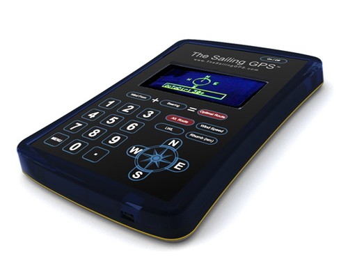
The Sailing GPS Chris Winsor
Since the dawn of sailing, mariner’s have struggled with the upwind dilemma. We know that we slow down when we pinch up, and that we go faster with the wind on the beam, but just how far off the wind is optimum when we are trying to tack to a destination upwind? And how long should we spend on each leg of the tack?
Experienced sailors know that opting for speed, even if it means adding extra miles, more often than not gets you to your destination faster than sailing as close as you can toward it. But to date, there has never been an easy and mathematically accurate way to determine it.
Until now. After years of R&D, a Halifax-based company has developed the first gps designed for sailors, by sailors. The Sailing GPS represents a watershed moment in the history of navigational devices. For the first time, one can instantly determine the optimum tacking angle to sail in order to arrive at a destination in the shortest possible time.
For cruisers, this means a dramatic increase in the ability to plan routes, and accurately forecast Tacking Time to Destination ™ . This essential knowledge means being able to accurately prepare for landfalls, and to keep to whatever schedule you have for scotches at sundown, etc. Prudent seamanship, however, also demands that sailors are able to make informed decisions about their actual time-to-destination when confronted by unfavourable weather, or other onboard contingencies.
For racers, the competitive advantage provided by The Sailing GPS is unmatched. Optimal tacking angles and leg lengths are instantly calculated and available at the helm. Finally: a definitive, precise indication of the fastest line to mark -- the result of a continuous computation of the ideal balance between distance and speed.
The Sailing GPS is the result of extensive research and development undertaken by a team of navigators and programmers on two continents, led by Dr. Craig Summers, who have successfully overcome the inherent flaws in predicting ETA based on Velocity Made Good.
Summers, a Halifax-based Ph.D. mathematician with expertise in computer modeling and electronics, is also an experienced Bluewater cruiser and producer of the acclaimed Cruising DVDs series, an interactive cruising guide that covers the entire historic route from the coast of Florida across the Gulf Stream, through The Bahamas, The Turks & Caicos, The Virgin Islands, and into The Caribbean.
'The Sailing GPS is the only device in the world that accounts for tacking when calculating distances, time of arrival, and optimal routes,' says Summers with typical modesty. 'The Sailing GPS does this automatically.'
I first became aware of Dr. Summers and The Sailing GPS while researching the twin concepts of Velocity Made Good (VMG) and Estimated Time of Arrival (ETA). My desire to understand these better was born of my frustration during several long distance races, as I struggled to determine the best tacking angles and how long to hold them.
After all, doesn’t VMG give you your speed toward the target, and ETA how long it’ll take to you to get there?
Here is the startling discovery: For tacking sailboats, VMG is NOT a valid measure of velocity, and SHOULD NOT be used to estimate arrival time. As Dr. Summers puts it simply, 'If you see five knots as your VMG and you have five nautical miles to go, it would be a mathematical error to conclude you will be there in an hour.'
Summers goes even further, to state that since VMG provides erroneous readings of velocity and ETA when tacking, it should not be used for navigation.
The reasons for this are both complex and intuitive. Does ETA mean as the crow flies, with no tacks? If not, how does the device know how when I intend to tack, or how long I intend to hold it? As anyone who has ever used a chart plotter will know, just when you start tacking, the ETA display goes blank. That’s in recognition of precisely this complexity.
Then what about VMG? Surely ETA is a reflection of VMG? The disturbing thing here is that VMG contains an inherent flaw: as your tack takes you further from your ‘rhumb’ line (the straight line to your destination) VMG gradually decreases. In fact, it goes to zero when your target is at 90 degrees (just off the beam) and will actually go negative beyond 90. So the longer you hold your tack, your VMG erroneously gives the illusion that you are slowing down or heading increasingly off-course, even if you remain on the correct heading and your speed remains constant!
The only mathematically correct way, therefore, to determine Tacking Time to Destination ™ is to use actual boat speed, then calculate distances using trigonometry in order to project arrival times. Which is exactly what The Sailing GPS does.
Even more impressive, the device includes an algorithm that learns your own boat’s unique speed characteristics, which is far more accurate when determining actual tacking-time to destination than using generic polar plot specifications from manufacturers, or from simulated models.
That’s important, because even two identical boats sailing on the same tack could have very different speed profiles depending on the condition of the sails, bottom growth, amount of fuel, water and gear onboard, etc.
After six prototypes, and years of research and development, Summers says that manufacturing of this breakthrough sailing device has finally begun.
The Sailing GPS is lightweight, daylight –readable and submersible. It is easily mounted on a bulkhead with Velcro, and comes with a drypak waterproof pouch with tie-down loops, for additional protection against the elements.
The Sailing GPS is also Bluetooth wireless enabled, for sharing GPS data with existing PC-based chart-plotters.
Suggested retail price is $299 US. Available for shipping before January 2010. For more info, check out www.TheSailingGPS.com.
If you want to link to this article then please use this URL: www.sail-world.com/62730