Audi Hamilton Island Race Week Day 2 Weather - light again!!
by Issued by Kenn Batt on 23 Aug 2009
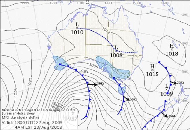
Day-2-4am - Audi Hamilton Island Race Week Bureau of Meteorology
http://www.bom.gov.au
2009 Audi Hamilton Island Race Week Weather Forecast
Issued by Kenn Batt at 0700hr For Sunday 23rd August 2009
Nil Warnings current.
Synoptic Discussion:
Today is expected to be a lot like yesterday!
The only consolations being the sunny and warm conditions and the wonderful scenery.
A weak ridge of high pressure lies over the race area. The gradient wind is currently from 340deg at around 8-10kn.
Observations:
At 0600hr the surface winds at Hamilton Island NNW’ly at 3kn gusting 4kn, (temp 20C, pressure 1017hPa) indicative of the weak gradient flow. At Hardy Reef (further offshore) the wind was NE at 5kn.
Forecast Winds for open water 4nm East of Surprise Rock (i.e. east of Hamilton Island) (Read Discussion below)
1000:MD360 DR(320-030) MS06 SR03-11kn
1200:MD050 DR(360-080) MS06 SR03-11kn
1400:MD060 DR(020-090) MS07 SR04-12kn may see 9-10kn ave?
1600:MD060 DR(020-090) MS09 SR04-13kn may see 9-11kn ave?
1800:MD060 DR(020-090) MS08 SR04-12kn
Note 1: First column is mean wind direction in deg Magnetic (MD). It is the
10min average (mean) value at a height of 10m above the water leading up to the hour quoted. The second column is the directional range (DR) of the wind direction in deg Mag. This takes into account the natural oscillation of the wind and is a function of the atmospheric stability, etc. The third column is the mean speed (MS) in knots (kn) and is the average 10min value leading up to the hour quoted at a height of 10m above the water. The last column is the wind speed range (SR) in knots and is the lowest wind speed to highest wind speed in the 10min leading up to forecast hour.
Discussion
This forecast has been extremely difficult to construct with model guidance everywhere due to the light nature of the synoptic situation.
Again like yesterday, it won’t be a good day from a wind versus tide perspective.
With the very loose ridge still over us, the winds will be light and flicky again today. There will be a tendency for the wind direction to draw more left than forecast (310-360deg) and 2-3kn stronger during the latter of the afternoon in the Whitsunday Passage area generally and also inside Dent Is.
Direction will have a lot of right tendency on the eastern side of the Islands (and within a 1nm or so of the mainland) due to greater effect of the sea breeze component.
Wind will be lighter and very flicky in the lee of any landmass e.g. Whitsunday Island, etc.
Be extra, extra careful again today with the light wind coupled with strong ebb and flood tides.
Natural oscillations today around 20 to 50 deg away from effects of topography, tending around 50 to 90 deg closer to the effects of any land mass.
Weather
Some early fog patches then dry and partly cloudy. Take plenty of sunscreen and warm clothes in case?
Maximum land temperature at Hamilton Island: 25-26 degrees. Sea Temperature: about 23 degrees.
Wind Waves :
0.1 to 0.5metres, less in lee of land, more when wind wave opposes tidal current.
(Wave heights quoted are Significant wave heights).
Current : A strong ebb this morning followed by a strongish flood this afternoon. Be extremely careful in channels, etc.
Remember: Tide floods to the south and ebbs to the north in the Whitsundays.
Tide at Shute Harbour: Low of 0.39m at 0630hr and High of 3.06 at 1245hr and Low 0.67m at 1837hr.
Outlook
Monday: Similar (unfortunately)
If you want to link to this article then please use this URL: www.sail-world.com/60443