Learn PC-Based Routing with VORG Game
by David Brayshaw on 12 Jan 2009
Predicted Winds Along Comparison Routes - Volvo Ocean Race David Brayshaw
The virtual regatta' known as the Volvo Ocean Race Game provides a great opportunity for ocean navigators to work with the latest in routing software, at nominal cost, and apply it in semi-realistic conditions. Advantage Racing has created a special version of their software to match the way the Game works, so you can compare directly to progress in the game.
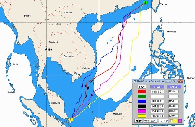
Routing software computes all possible courses, from one point to another, based on wind forecasts and the performance characteristics of your boat (how fast you can sail at various wind speeds and wind angles, often called a 'polar' file). This involves millions of computations, and is something that only a computer can do. A sample routing calculation is shown in Fig. 1, from a point east of Singapore to a point south of the Strait of Taiwan. All routing software computes the 'optimal' course between two points (taking the least time), but Advantage is unique in computing additional routes for comparison. The optimal route is plotted in red and comparison routes in other colors. The times for each route are shown in the 'Best Course comparisons' box. In this case the optimal route takes some 144 hours, with comparison routes ranging to as much as 206 hours (a huge difference).
Advantage allows you 'step along' the routes and see where your boat is predicted to be on each one (black dots shown in Fig. 1). The figure shows predicted positions for the intermediate time 10:17 on 1/1, and also displays distance to the destination (right-column labeled DTG). The comparison routes give you some perspective on the optimal route, showing just how much time you lose by choosing an alternative and how far off you can stray without a significant loss in time. Another option (see Fig. 2) displays the predicted winds along the routes, a useful display that shows wind data from different times in a single image.
There are many other tools one can use. Fig. 3 shows an upwind situation, with laylines emanating from an intermediate waypoint '7' and the boat situated to the south. This 'Super-If' tool computes the headings and times required to reach the laylines, from which you can sail directly to the waypoint. This is normally employed over short distances, where the wind can be taken as constant, but it works just as well at much longer distances in the virtual regattas (these hold wind unchanged for 12 hours).
The VORG 'Special Edition' combines charts and the necessary polar file with a copy of Advantage Level 3, the top-level program from Advantage Racing. Although computations have been modified to conform to the Game, operation is identical to what you would do navigating across the globe. Advantage has many unique functions which you can explore while applying it to the Game.
The concept of this package is to teach PC-based routing and allow navigators to experiment with the latest in routing software without incurring the cost of actual purchase. There is a nominal cost of $20 per leg, which also enables the user to compete with others for prizes, including a full, unrestricted copy of the program (normally $1,900).
Although limited-period 'demos' of competitor software can be found on the web, these unmodified programs (like the standard Advantage program) will produce inaccurate and unreliable results when used to predict routing in the VORG game. With this Special Edition, a navigator can see how course decisions are implemented and compare to over 100,000 others playing the Game. For full details, see www.goflow.com/advolvo.htm.
If you want to link to this article then please use this URL: www.sail-world.com/52728