Sailing Australia's East Coast-A New Valuable Tool
by Nancy Knudsen on 31 Oct 2008
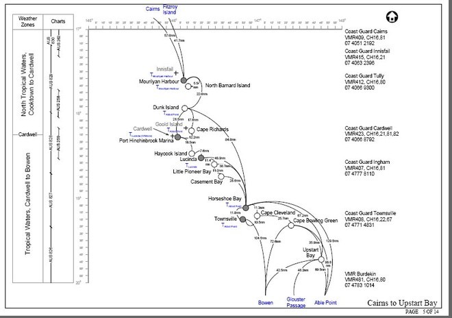
Passage Planner example page SW
Part of the challenge for the recreational cruising sailor is the amount of necessary research to undertake a passage, whether it be a day sail or a six month sojourn.Now one Australian sailor has just made that task a whole lot easier!
How far can I sail today? How long should my next passage be? What are the alternatives? Now, if you are sailing anywhere between Cairns in North Queensland and Eden in Southern New South Wales, these questions can be answered with the click of a small Mouse.
The programme is the brain child of cruising sailor Rob Starkey, and has been in development for a many months, with members of the Royal Prince Alfred Yacht Club using beta versions for testing purposes.
As well as planning for distances and appropriate routes, the planner identifies minimum chart requirements, Pilots, tide tables and Queensland Zone restrictions.
You'll also find an overview of the minimum safety requirements as legislated by state Governments and as required by Yachting Austrlaia for YA events.
...and that's not all. There are useful links and schedules for weather forecasts, and strip charts for the long coastline, each covering approximately 180 nautical miles showing the relative geographical position of ports and anchorages, 'normal' passage scenarios with distances. Each strip chart (see sample diagram) identifies minimum chart requirement, weather forecast zones, VMR locations and contacts.
There's even a speed distance elapsed time table chart and a 'when to tack' downwind chart.
A huge amount of work has gone into this comprehensive programme. While in beta mode it has been tested comprehensively and many changes made, as shown below:
22 June 2008 - uploaded version 1.3 of the planner with the following updates:
Clarification of approval requirements when passing through pilotage areas of Gladstone and Mackay.
Definitions of pilotage areas.
Note on new lead structure and lights for Pancake Creek.
26 June 2008 - version 2.0 of the planner available.
It now includes the East Coast of Australia from Cairn in North Queensland right down to Eden/Twofold Bay on the Southern tip of NSW.
And anyone can play a role in keeping the information up to date by leaving a comment here with corrections or suggestions.
10 August 2008 - version 2.1 with some corrections and re-arrangement of pages.
Updated note regarding direction of tide flooding in North Queensland.
Changed paging to create a consistent flow of maps from North to South.
Corrected telephone number for VMR Mackay.
24 August 2008 - version 2.11 minor correction
Updated link to NSW tide table
29 September 2008 - version 2.2
By thorough testing, Version 2.2 is now probably perfect. As Skipper Marius Coomans, who has used the program, said, "It's very complete, covering time/distance charts, chart and pilot references, VMR details, even a ready reckoner to work out whether to tack going downwind. In short, it's a beauty! Don't leave home without it..."
It does not aleviate the responsibility of each skipper to make his own judgements and decisions - and nor should it - but it does point the way to the correct material to which you need to be paying attention.
...and for that, it's brilliant.
Click
HERE to find Rob's Passage Planner
If you want to link to this article then please use this URL: www.sail-world.com/50356