Garmin BlueChart® g2 Vision™ takes charts to the future
by Kyle Matthews on 12 Jul 2007
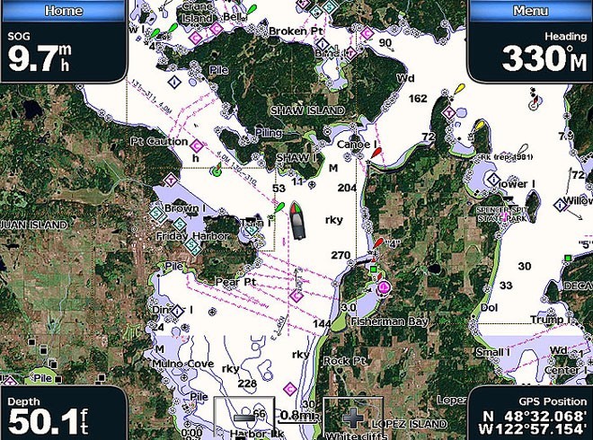
Satellite Imagery Garmin
http://www.gme.net.au
Amazing developments in chart plotting as the Garmin BlueChart g2 Vision has set the industry standard in premier electronic chartplotter-based marine charting. Simply by plugging an optional g2 Vision SD card into your new Garmin chartplotter you can tremendously expand its full graphical capabilities.
In addition to detailed marine charting, you will have access to premium mapping features such as high resolution satellite imagery, 3D perspective above and below the waterline, auto guidance technology, fishing charts, tides and coastal roads with points of interest.
BlueChart g2 Vision SD cards enhance the preloaded maps on your chartplotter and add a whole new dimension of exceptional features such as:
Satellite Imagery: You can overlay high resolution satellite imagery on land, sea or both portions of the navigation chart, providing the mariner with unparalleled situational awareness. It’s the most realistic map display you’ve ever seen on a graphical chartplotter. And you can 'navigate on the picture' with a clear dynamic presentation of your boat’s current position.
Mariner’s Eye 3D: Mariner’s Eye 3D provides a bird’s eye view from above and behind the boat showing the chart information for a quick, reliable and easy position fix. A great feature to have when navigating or trying to identify entry and exit routes in unfamiliar harbours or anchorages.
[Sorry, this content could not be displayed]
Fish Eye 3D: Navigating around tricky shoals, reefs and channels or searching for new fishing grounds has never been so easy, Fish Eye 3D provides a realistic underwater view that visually represents the sea floor according to the chart’s information.
[Sorry, this content could not be displayed]
Auto Guidance: Like having a guide to local hazards and waterways always on deck, Auto Guidance technology searches chart contents to suggest the best route for a safe passage to your next destination.
[Sorry, this content could not be displayed]
Fishing charts: The Fishing Chart feature provides bathymetric data to emphasise bottom contours and depth soundings. Other navigation information is removed to reduce clutter and help give clearer definition to the sea floor.
Detailed BlueChart g2 Vision maps are included on the card to supplement the maps on your chartplotter.
For additional information on Garmin’s new g2 Vision or any other Garmin products please visit our website – www.gme.net.au. Alternatively, contact your local GME/Standard Communications Branch.
[Sorry, this content could not be displayed]
If you want to link to this article then please use this URL: www.sail-world.com/35627