Hurricane Maria rapidly intensifies to Category 5 near Leeward Islands
by Weather.com on 19 Sep 2017
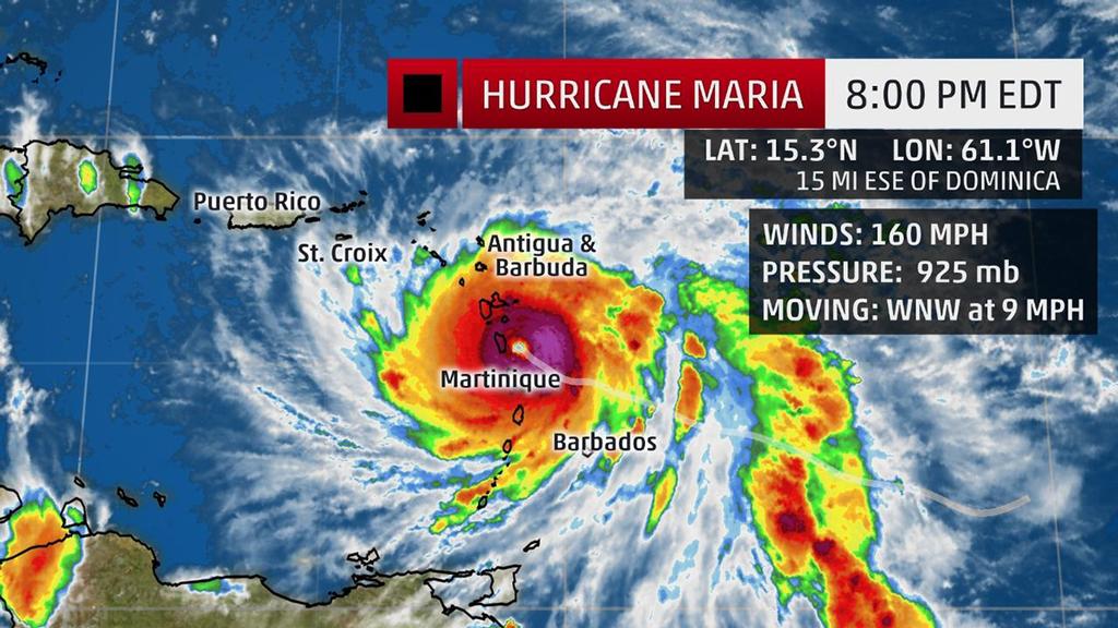
Current Storm Status - The highest cloud tops, corresponding to the most vigorous convection, are shown in the brightest red colors. Clustering, deep convection around the center is a sign of a healthy tropical cyclone. The Weather Channel
Hurricane Maria is pounding the Leeward Islands as an extremely dangerous Category 5 hurricane and will follow that up with a potentially devastating hit on the already storm-weary Virgin Islands and Puerto Rico, parts of which are still recovering from Hurricane Irma less than two weeks ago.
(More:
Hurricane Central |
Caribbean Prepares for Maria)
Maria is currently located about 15 miles east-southeast of Dominica and is moving west-northwest at near 10 mph.
Hurricane conditions should be spreading across Dominica, Guadeloupe and Martinique during the next few hours, with tropical storm conditions already occurring over portions of the Leeward Islands.
A hurricane warning remains in effect for Guadeloupe, Dominica, St. Kitts, Nevis, Montserrat, the U.S. Virgin Islands, the British Virgin Islands, Puerto Rico, Culebra and Vieques. A tropical storm warning has been issued for Martinique, Antigua, Barbuda, Saba, St. Eustatius, St. Maarten, Anguilla and St. Lucia.
Hurricane watches include Saba, St. Eustatius, St. Maarten, St. Martin, St. Barthelemy, Anguilla and from Isla Saona to Puerto Plata in the Dominican Republic.
Tropical storm watches have been posted for St. Vincent and the Grenadines, as well as from west of Puerto Plata to the northern Dominican Republic-Haiti border.
Maria rapidly intensified Monday thanks to a combination of low wind shear, a moist atmosphere and warm ocean temperatures.
'Maria is developing the dreaded pinhole eye,' the National Hurricane Center said in its late Monday afternoon discussion. This is an indication of a strong hurricane, and just three hours later, Maria reached Category 5 intensity.
The last time the Atlantic had two Category 5 hurricanes in the same season was in 2007 with Dean and Felix. Irma was this year's first Category 5 hurricane.
Leeward Islands Impacts
Conditions have deteriorated quickly in Dominica, Guadeloupe, Martinique and St. Lucia as the eye of Maria nears the island of Dominica.
Hurricane conditions are possible through Monday night and Tuesday. This includes some locations in the northern Leeward Islands that were devastated by Hurricane Irma.
Of course, the strongest winds will occur within the small eyewall of Maria.
A storm surge of up to 6 to 9 feet above normal tide levels is expected in the hurricane warning area, including the U.S. Virgin Islands and Puerto Rico.
High surf and dangerous rip currents are already impacting the Lesser Antilles and will persist even for a day or so after Maria's center passes by.
Rainfall totals of 10 to 15 inches are possible in the central and southern Leeward Islands, with locally up to 20 inches in some spots. That has the potential to produce widespread, life-threatening flooding and mudslides, particularly on mountainous terrain.
Maria is also expected to produce four to eight inches of rain, with locally up to 10 inches, over the northern Leeward Islands from Barbuda to Anguilla.
Two to four inches of rain, with locally up to six inches, can be expected in the Windward Islands and Barbados.
Puerto Rico, Virgin Islands and Hispañola Impacts
Maria may bring a devastating combination of storm-surge flooding, destructive winds and torrential rain to Puerto Rico and the Virgin Islands, potentially as Category 4 or 5 hurricane Wednesday.
Residents and visitors in Puerto Rico and the Virgin Islands should be making preparations immediately for this upcoming hurricane strike.
'Locations may be uninhabitable for weeks or months,' according to the National Weather Service in San Juan, Puerto Rico.
Conditions may begin to deteriorate starting Tuesday in the Virgin Islands and then spread west toward Puerto Rico by Wednesday. Portions of the Dominican Republic and Haiti could see impacts from Maria begin as early as Thursday.
Puerto Rico may see 12 to 18 inches of rain, with locally up to 25 inches in some areas, through Thursday.
The Virgin Islands are expected to receive 10 to 15 inches of rain, with locally up to 20 inches.
The eastern Dominican Republic is forecast to pick up four to eight inches of rain, with isolated 12-inch amounts.
These rainfall totals have the potential to produce widespread, life-threatening flooding and mudslides.
Prior to Irma, only four other Category 4 hurricanes had tracked within 75 miles of central Puerto Rico in historical records dating to the late 19th century. Hurricane Hugo in 1989 was the last to do so, before Irma's Category 5 swipe just two weeks ago.
Only three times before have two hurricanes passed within 75 nautical miles of the Virgin Islands during the same hurricane season.
Will Maria Threaten the U.S. East Coast?
In short, we cannot determine at this time whether Maria will directly impact the East Coast of the U.S. next week.
Whether Maria will ever pose an East Coast threat will depend on steering currents in the upper atmosphere over the western Atlantic Ocean and the eastern United States that cannot be pinned down this far in advance.
Interestingly, the potential for Jose to stall off the Northeast coast this weekend could play some role in determining Maria's long-term future path. For more details, see the link below.
(More: How Jose Could Affect Maria's Long-Term Steering)
Also, if Maria interacts with the higher terrain of Puerto Rico and/or Hispañola, that could also affect its future track and intensity.
If Maria would strike the U.S., and again, that is not by any means a certainty, that would not happen until early next week.
For now, all residents along the East Coast and Gulf Coast should monitor the progress of Maria.
Keep an eye on weather for updates in the days ahead for the latest details on Maria.
If you want to link to this article then please use this URL: www.sail-world.com/157378