Earth Wind Map - with typhoons
by Sail-World Cruising on 8 Oct 2014
SW
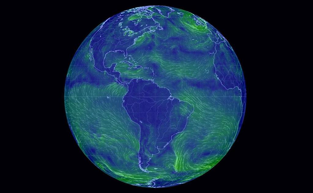
The Earth Wind Map is an amazing project to visualize global weather conditions carried out by Tokyo based software engineer Cameron Beccario, resulting in a beautifully mesmerising depiction of the earth's winds. Weather data is produced by the Global Forecast System (GFS), operated by the US National Weather Service. Forecasts are produced four times daily and made available for download from NOMADS. The files are in GRIB2 format and contain over 300 records.
Formerly a Visual Basic developer with Microsoft Beccario moved to Japan in 2002 and has been developing online trading platforms.
The project, which only went live in December 2013 is the child of a former Tokyo Wind Map project, inspired by the fm/wind map of the USA says Beccario.
The actual map date is provided by Natural Earth, but converted into another format.
In detail, a gentle breeze is shown by a thin strand of green, while strong winds are bright yellow. The strongest currents are bright red.
Users can drag the globe to their desired location and click on the spot they want to find out what the wind speed is.
Users can also zoom in on the currents, which are colour-coded to show the severity of the wind. The detail is quite extraordinary. A region that looks calm at a glance is seen to be rippling with winds on closer inspection, using the mouse wheel to zoom in.
Historical data is available, as is wind data at different heights. This project is a true Work in Progress. Current data has now been added and Beccario continued to work on new features over the last year.
The system also does something else not really seen before. If you ever doubted the existence of the fabled gyres of the oceans, doubt no more. The five gyres can be observed in graphic fluid lines, just as always predicted.
Could you use this for deciding your sailing plans? It is after all taken from GRIB files. It's too early to tell. You decide. However Beccario is at pains to point out that a lot of the data is interpolated.
To access the 'Earth Wind Map', click here. Navigation is a matter of exploration.
If you think you might like to set up your own Earth Wind Map, click here.
Watch the video to learn more about how it works:
If you want to link to this article then please use this URL: www.sail-world.com/127527