Halong becomes a Super Typhoon; Japan in harm's way
by Adam Douty on 3 Aug 2014
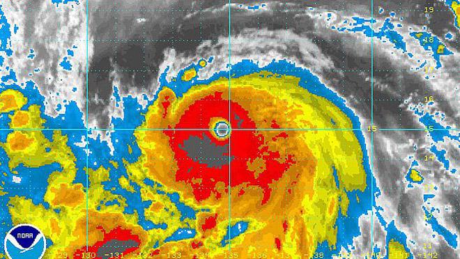
Satellite Image of Super Typhoon Halong as of Sunday morning, local time NOAA .
http://www.noaanews.noaa.gov/
Halong has been rapidly intensifying to start the weekend, becoming a super typhoon early Saturday night, local time, with maximum sustained winds of 250 kph (155 mph).
Halong is expected to remain a very dangerous typhoon through the rest of the weekend and into the coming week.
While not impacting land through at least Tuesday local time, Halong will remain over the open waters of the Philippine Sea and creating life-threatening, dangerous seas for shipping interests.
There is currently some wind shear affecting the storm which, if strong enough, typically weakens tropical systems. However, Halong has easily overcome this shear and now has a very well-defined eye along with a robust eye wall.
Early in the coming week, environmental conditions will remain conducive for tropical development along the track the storm. This should allow Halong to remain a very powerful typhoon. As a result, AccuWeather.com meteorologists expect there to be the potential for a major typhoon to impact southern Japan later in the week.
While the current path of Halong puts the northern Ryukyu Islands and southern Japan at greatest risk of a direct landfall with heavy rain and damaging winds, all residents of Japan, the Korean Peninsula and even northeastern China should closely monitor the typhoon for potential dangers and any adjustments to the forecast track.
Impacts in southern Japan are expected to worsen beginning on Thursday with typhoon conditions possibly lasting into Saturday in some locations.
For full article go to http://www.accuweather.com/en/weather-news/halong-becomes-super-typhoon-j/31488164
If you want to link to this article then please use this URL: www.sail-world.com/125153