El Niño (Part 2). Effects on the Pacific Ocean
by NOAA on 12 Jul 2014
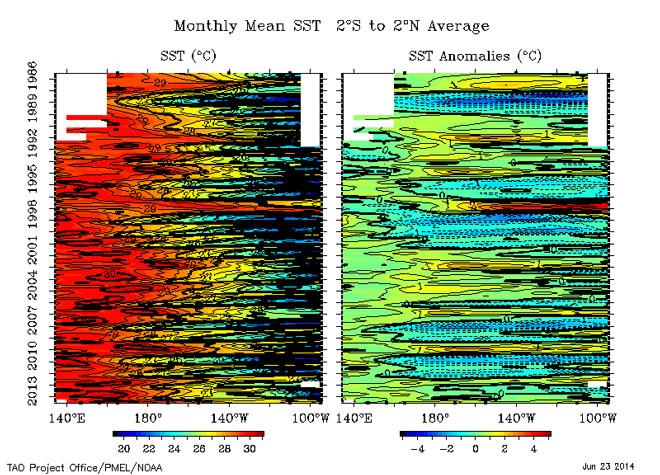
Mean and anomalies of sea surface temperature from 1986 to the present. Notice historical El Niños in 1986-1987, 1991-1992, 1993, 1994 and 1997 NOAA .
http://www.noaanews.noaa.gov/
El Niño is characterized by unusually warm ocean temperatures in the Equatorial Pacific, as opposed to La Niña, which characterized by unusually cold ocean temperatures in the Equatorial Pacific. El Niño is an oscillation of the ocean-atmosphere system in the tropical Pacific having important consequences for weather around the globe.
Above, you see the sea surface temperature at the Equator in the Pacific Ocean (Indonesia is towards the left, South America is towards the right). Time is increasing downwards from 1986 at the top of the plot, to the present, at the bottom of the plot. The first thing to note is the blue 'scallops' on the right of the plot, in the eastern Pacific. These indicate the cool water typically observed in the Eastern Pacific (called the 'cold tongue').
Cold tongue temperatures vary seasonally, being warmest in the northern hemisphere springtime and coolest in the northern hemisphere fall. The red color on the left is the warm pool of water typically observed in the western Pacific Ocean. El Niño is an exaggeration of the usual seasonal cycle. During the El Niño in 1986-1987, you can see the warm water (red) penetrating eastward in the Spring of 1987. There is another El Niño in 1991-1992, and you can see the warm water penetrating towards the east in the northern hemisphere spring of 1992.
The El Niño in 1997-1998 is a very strong El Niño. El Niño years are easier to see in the anomalies on the right hand panel. The anomalies show how much the sea surface temperature is different from the usual value for each month. Water temperatures significantly warmer than the norm are shown in red, and water temperatures cooler than the norm are shown in blue.
In the right-hand plot of sea surface temperature anomalies, it is very easy to see El Niños, with water warmer than usual (red) in the eastern Pacific, during in 1986-1987, 1991-1992, 1993, 1994 and 1997-1998. Notice the very cool water (blue), in the Eastern Pacific, in 1988-1989. This is a strong La Niña, which occurs after some (but not all) El Niño years. 1995-1996 was a weaker La Niña year. It is unusual for El Niños to occur in such rapid succession, as has been the case during 1990-1994.
El Niño was originally recognized by fisherman off the coast of South America as the appearance of unusually warm water in the Pacific ocean, occurring near the beginning of the year. El Niño means The Little Boy or Christ child in Spanish. This name was used for the tendency of the phenomenon to arrive around Christmas.
La Niña means The Little Girl. La Niña is sometimes called El Viejo, anti-El Niño, or simply 'a cold event' or 'a cold episode'. El Niño is often called 'a warm event'.
There has been a confusing range of uses for the terms El Niño, La Niña and ENSO by both the scientific community and the general public, which is clarified as Southern Oscillation Index, El Niño and La Niña.
http://www.pmel.noaa.gov/
For El Niño Part 1, go to our previous
story
If you want to link to this article then please use this URL: www.sail-world.com/124370