Cat 5 Cyclone ITA expected to hit FNQ coast at high tide
by . on 10 Apr 2014
Commonwealth of Australia, Bureau of Meteorology
Severe Tropical Cyclone Ita has been upgraded to the highest category level as it moves towards the Far North Queensland coast.
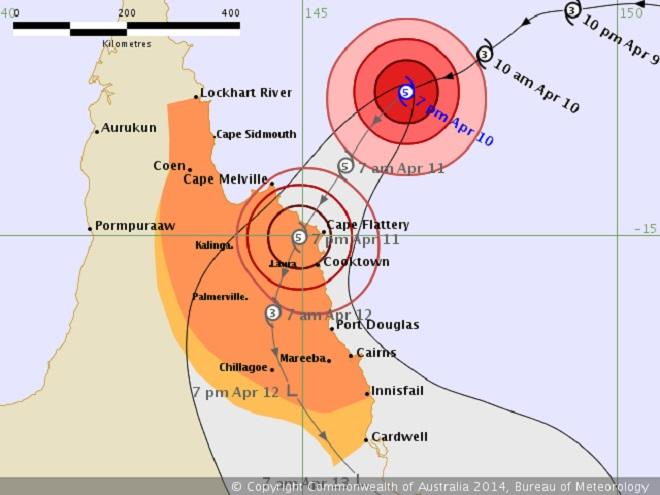
On Thursday ayt1900 hours, the system,was 345 kilometres north-north-east of Cooktown and moving west-south-west at 15 kilometres per hour.
Ita is now expected to make landfall between Cape Melville and Cape Tribulation, coinciding with the high tide on Friday afternoon, with very destructive winds of around 250 kilometres per hour near the centre, and is expected to cause flash flooding with falls of up to 400 millimetres in coastal areas..
The weather bureau says the cyclone is the most severe system it has seen approach the Queensland coast since Cyclone Yasi in 2011.
'It has definitely intensified over the last six hours and it is showing a structure with a real evident eye in the centre,' senior forecaster Andrew Bufalino told tthe ABC.
Cooktown residents are being warned that properties built before 1985 may not be able to withstand Ita's impact.
Premier Campbell Newman has cut short his trade trade trip to Asia and has visited Cooktown, which is at the centre of the cyclone preparation effort.
He has urged residents of those dwellings built before the building code was amended to seek shelter elsewhere.
Mr Campbell says one third of the dwellings in the town of about 2,400 people could be vulnerable.
'We're just asking people to make an assessment. If it's a more modern house, you're probably safe if it's well maintained. Otherwise consider going to another residence,' he told 7:30.
Cook Shire Mayor Peter Scott says the cyclone shelter in Cooktown will open at 7:00am on Friday.
Residents are also being urged to take the opportunity now to charge mobile phones and prepare an emergency kit, which should include a radio and batteries, drinking water and non-perishable foods.
Authorities say they have a wide-ranging emergency plan and are taking into account the possibility that the system will track towards Cairns.
'We don't put all the eggs in one basket,' Acting Chief Superintendent Brett Schafferius said.
'The planning that is taken by the councils and the districts allows for the flexibility and the change as mother nature changes her mind.'
IDQ20023
Australian Government Bureau of Meteorology
Queensland
Tropical Cyclone Warning Centre
Tropical Cyclone Advice Number 11
Issued at 11:09 pm EST on Thursday 10 April 2014
A Cyclone Warning is current for coastal areas from Lockhart River to Innisfail including Cooktown, Port Douglas and Cairns, and extending inland to areas including Kalinga, Palmerville, Mareeba and Chillagoe.
A Cyclone Watch is current for coastal areas from Innisfail to Cardwell, and extending to adjacent inland areas.
At 10:00 pm EST Severe Tropical Cyclone Ita, Category 5, was estimated to be 320 kilometres north northeast of Cooktown and 455 kilometres north of Cairns, and moving west southwest at 15 kilometres per hour.
Severe Tropical Cyclone Ita, Category 5, poses a significant threat to communities along the far north Queensland coast. At this stage it is expected to move to the southwest and make landfall between Cape Melville and Cape Tribulation later on Friday as a Severe Category 5 Tropical Cyclone with Very Destructive Winds near the core and gales extending some distance from the landfall location.
Destructive Winds may develop between Cape Melville and Cooktown from as early as sunrise Friday morning before extending inland to Laura and further south to Cape Tribulation and possibly Port Douglas later in the day.
Gales may develop between Lockhart River and Cape Tribulation during Friday morning before extending further south to Innisfail and inland to Kalinga, Palmerville, and Laura, and Chillagoe later in the day as the system moves
closer to the coast and over land.
Coastal residents between Cape Melville and Cape Tribulation including Cooktown are specifically warned of the dangerous storm tide as the cyclone crosses the coast later on Friday. The sea is likely to rise steadily up to a level which will be significantly above the normal tide, with damaging waves, strong currents and flooding of low-lying areas extending some way inland.
People living in areas likely to be affected by this flooding should take measures to protect their property as much as possible and be prepared to follow instructions regarding evacuation of the area if advised to do so by the authorities. Coastal residents between Innisfail and Port Douglas, including Cairns should monitor the situation in case the cyclone takes a more southerly track than expected.
Very heavy rain, which may lead to flash flooding, is expected to develop about parts of the Peninsula and North Tropical Coast and Tablelands districts on Friday and persist into the weekend.
People between Lockhart River and Innisfail and adjacent inland areas including Laura, Kalinga, Palmerville, Mareeba and Chillagoe should immediately commence or continue preparations, especially securing boats and property.
- For cyclone preparedness and safety advice, visit Queensland's Disaster Management Services website (www.disaster.qld.gov.au)
- For emergency assistance call the Queensland State Emergency Service (SES) on 132 500 (for assistance with storm damage, rising flood water, fallen trees on buildings or roof damage).
People between Innisfail and Cardwell and adjacent inland areas should consider what action they will need to take if the cyclone threat increases and listen to the next advice at 2am EST.
- Information is available from your local government
- For cyclone preparedness and safety advice, visit Queensland's Disaster Management Services website (www.disaster.qld.gov.au)
- For emergency assistance call the Queensland State Emergency Service (SES) on 132 500 (for assistance with storm damage, rising flood water, fallen trees on buildings or roof damage).
Details of Severe Tropical Cyclone Ita at 10:00 pm EST:
.Centre located near...... 12.8 degrees South 146.3 degrees East
.Location accuracy........ within 20 kilometres
.Recent movement.......... towards the west southwest at 15 kilometres per hour
.Wind gusts near centre... 285 kilometres per hour
.Severity category........ 5
.Central pressure......... 934 hectoPascals
The next advice will be issued by 2:00 am EST Friday 11 April.
If you want to link to this article then please use this URL: www.sail-world.com/120977