Cruising sailors needed to help improve the world's charts
by Sail-World Cruising on 26 Feb 2014
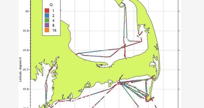
Chart sample showing tracks and depths SW
If you've ever been in a situation where your GPS is telling you one thing while 'looking out the window' tells you another, you'll be engaged by a new initiative which is pleading for the help of cruising sailors to improve the world's charts - and therefore eventually the GPS result that you see on your electronic chart as well.
In many countries around the world, coastal waters are inadequately surveyed, and yet these are the areas where most detailed and up to date information is required. Information on the state of surveying around the world is published by the International Hydrographic Organisation (IHO) in their document C-55.
Even in well sailed countries like the UK and Australia the issue exists. For instance, the area of coastal waters in Britain that is adequately surveyed is below 50%. In Australia it is 35%. The situation is caused by the high cost of hydrographic surveying - about €25 000 per square mile - and also because the remit of many hydrographic offices is aimed at the needs of large SOLAS ships and defence.
So, as a potential solution, in walks TeamSurv, an organisation funded by a Satellite Navigation competition, an initiative set up to support start-ups that use satellite data. Teamsurv are going to attempt to change this situation, by using the data provided by sailors everywhere in the world, but particularly in areas which are inadequately charted.
Teamsurv wants to harness the hundreds, maybe thousands, of boats out on the water to start collecting up-to-date information about what lies beneath the surface.
By providing a small data logger to put onboard, Teamsurv can collect and collate the voyages of boats and build up a more detailed map.
The data is published online and made available to other organisations to use, share and adapt.
How TeamSurv works:
When you become a TeamSurv data logger, you will be provided with a data logger that automatically records data from your instruments. If you use a PC on board then this is our SmartLog for Windows software, or otherwise we will loan you a SmartLog USB hardware logger.
Alternatively, if you use a Garmin GPSMap plotter with a user memory card, or PC navigation software from SeaPro, Software on Board, Expedition or Nobeltec, you can log the data using your existing kit and then upload it to the web site.
During each trip a log file is automatically created, and once ashore you upload it to the TeamSurv web site, where it is processed and combined with the other data and available for viewing.
TeamSurv then shows the data provided by all of their data loggers on the web site, overlaid over Google Maps. They are currently implementing corrections for tide height etc., and so shortly it will be possible to see both the logged and the corrected data.
The project is progressing well, according to Teamsurv director Tim Thornton. 'We do already correct for tide height (and also for variations in the speed of sound, that affect depth sounder measurements – this is affected by water temperature and salinity). On the data view, Processed data is corrected, whereas Raw is uncorrected.'
The results are already showing and can be of benefit to some users. 'For many areas we have chartlets that can be downloaded as PDFs (see http://www.teamsurv.eu/Data/Charts/tabid/257/language/en-GB/Default.aspx),' says Thornton, 'We’re working on automating the production of these, so they are always up to date. We are also working on providing high detail electronic depth charts in a number of formats, which will be out in the next few months. These will be free of charge to all of our data loggers.'
How do I Join?
First register on the site, http://www.teamsurv.eu. This will allow you to see more information about the project and download the software logger, as well as allowing us to keep you informed of new developments.
Once registered, to become a logger you need to check you meet the requirements, and then just fill in the application form. This allows you to upload logged data and to have the loan of a hardware logger, if eligible.
What a fun project, if you are accepted!
If you want to link to this article then please use this URL: www.sail-world.com/119625