Navlink - new gizmo App for UK sailors
by Des Ryan on 6 Jan 2014
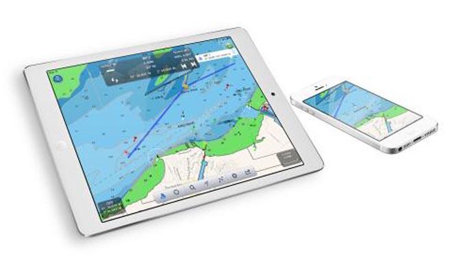
Navlink - ideal for iPad, and will work on the iPhone too, though for navigation the iPhone seems a little small. SW
There's always a new digital gizmo that you need to try. This week, for UK sailors, it's Navlink. Sailors are benefiting from the new offering from Digital Yacht which will enable you to explore, plan and navigate your sailing voyages in real time and high resolution on an iPad.
The system uses the latest UKHO (Admiralty) digital vector marine charts covering the whole of the UK and Ireland which are included with the £19.99 app.
Whilst using an iPad and NavLink is an attractive alternative to the cost of a dedicated touchscreen chart plotter, it does not compromise on features.
Charts can be presented north up or course up and routes and waypoints are created and edited using a simple touch screen interface. Real time navigation shows your current position, track, course, speed, ETA, VMG, bearing and distance to next waypoint.
There’s a simple A-B chart ruler too and you can tap on an object such as a buoy or nav-aid and get a pop up data window showing its characteristics. Its sharp, high-definition display enables simple zooming on detailed vector format charts, as well as allowing chart data to be layered and therefore de-cluttered.
It’s also designed to work seamlessly with Digital Yacht’s NMEA to WiFi devices so will integrate with your boat’s GPS and AIS systems. If AIS data is available, you’ll see AIS targets overlaid with all their identity information and a heading line as well as alarms for CPA and TCPA.
Utilising your on board GPS with these wireless servers means you don’t need a GPS enabled iPad. Even if your device is GPS enabled, it significantly reduces battery drain when using an external source. It also means your iPad/Phone can be used below deck and generally, the boat’s GPS is superior for marine based navigation
Other advanced features include tidal information, weather data from weather buoys showing current local conditions such as wind speed/direction and swell and full route planning capability with sharing – useful for keeping all the crew updated!
NavLink also helps with your watch keeping and lookouts. In its unique HorizonView mode, you can use the camera on the iPad to scan the horizon. You’ll get an overlay on the camera screen of nav-aids, AIS targets and waypoints which serves as a great visualisation tool.
For more information go to the website: www.digitalyacht.co.uk
If you want to link to this article then please use this URL: www.sail-world.com/118186