Audi Hamilton Island Race Week Day 2 - Weather forecast
by Kenn Batt on 19 Aug 2013
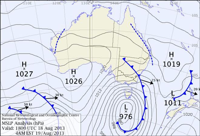
Surface chart 19th August - Audi Hamilton Island Race Week 2013 SW
Audi Hamilton Island Race Week Day 2 - Weather forecast issued by Kenn Batt at 0630hr for Monday 19th August 2013.
A weak high [1019 hPa] over the southern Coral Sea is expected to move slowly eastwards, maintaining a weak ridge onto the tropical east coast of Queensland. A surface trough of low pressure lies to the west of the area. This trough is expected to cross the coast early tomorrow morning.
Observations:
At 0600hr the surface wind at Hamilton Island was 270 deg at 3kn, gusting 4kn (temp 20C, pressure 1017hPa). At Hardy Reef (further offshore at 19.7S 149.2E) the wind was 090deg at 3kn.
Forecast Winds for Surprise Rock (to E of Hamilton Island) (Read Discussion below)
1000:MD060 DR(040-090) MS03 SR01-07kn could be light and variable?
1200:MD060 DR(040-090) MS05 SR02-10kn could be light and variable?
1400:MD050 DR(030-080) MS08 SR03-12kn
1600:MD050 DR(030-070) MS10 SR05-14kn
1800:MD030 DR(360-050) MS09 SR04-13kn
Note: The wind in the Whitsunday Passage is expected to commence as340-360deg at 2-6kt (ave) this morning before slowly shifting right to be 360-040deg at 6-10kn (ave) by mid-afternoon.
Key: First column is mean wind direction in deg Magnetic (MD). It is the 10min average (mean) value at a height of 10m above the water leading up to the hour quoted. The second column is the directional range (DR) of the wind direction in deg Mag. This takes into account the natural oscillation of the wind and is a function of the atmospheric stability, etc. The third column is the mean speed (MS) in knots (kn) and is the average 10min value leading up to the hour quoted at a height of 10m above the water. The last column is the wind speed range (SR) in knots and is the lowest wind speed to highest wind speed in the 10min leading up to forecast hour.
Discussion:
All models are pointing towards light synoptic NW to NE winds first up this morning tending to a pure sea breeze this afternoon.
The forecast gradient wind (wind at 900 metres) is expected to be 340-360deg at 10-15kn This scenario normally favours a sea breeze situation.
If the gradient wind increases to 15 to 20kn, then the sea breeze potential will drop to zero and a 320-340deg at 8-15kn will prevail over the race area? There is a 55% chance of this occurring?
There is also a 30% chance that the surface trough pushes east over the race area today. This would see the surface wind commence as 320-340deg at 6-12kn (ave) shifting to 260-220deg at 8-14kn (ave) then easing and shifting 140-090deg at 5-10kn (ave) behind the trough.
Wind direction and speed is expected to become more variable than forecast above over most parts of the race course due to changing topographical profiles i.e. wind speed enhancement (+3kn or so) due to funneling out of bays, some speed enhancement and wind directional changes around headlands and in passages. Lighter and more variable winds in the lee of islands, etc
Natural wind direction oscillations: around 20 to 30 deg, more/less due to topographical influences.
Weather:
Early low cloud or fog clearing to a mostly sunny day. Slight chance of a late afternoon or evening shower.
Maximum land temperature at Hamilton Island: 25 degrees.
Sea Temperature: about 21-22 degrees.
Wind Waves:
0.2 to 1.0 metres, less in lee of land, more when wind wave opposes tidal current.
(Wave heights quoted are Significant wave heights).
Current: A strong ebb this morning followed by slack water and then a strong flood developing late this afternoon/evening. Be extremely careful in channels, etc.
Remember: In general tidal currents flood to the south and ebb to the north in the Whitsundays. There are many localized variations however so be very vigilant.
Tide at Shute Harbour: High of 2.95 at 0910hr, Low 0.11m at 1458hr and High 4.00m at 2140hr.
Outlook: Tuesday: S to SE at 8 to 16 kn (ave).
If you want to link to this article then please use this URL: www.sail-world.com/113359