The disappearing Sandy Island - Scientist may have the answer.
by Nancy Knudsen on 20 Apr 2013
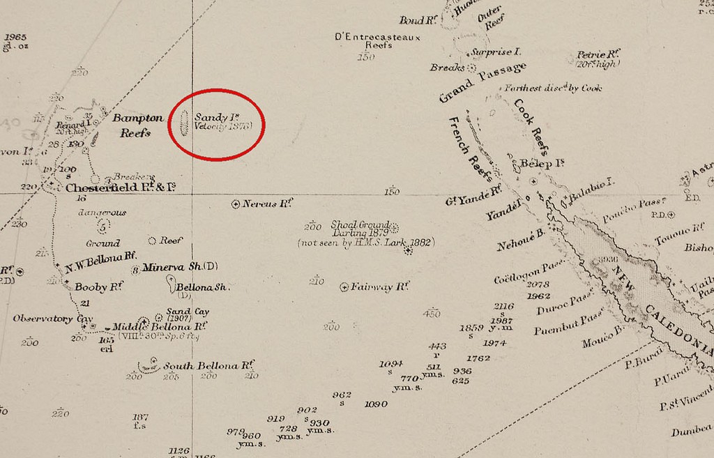
Sandy Island on an old chart SW


Where did the Coral Sea's Sandy Island go? This was the question posed by us in an article last November (see http://www.sail-world.com/Cruising/international/Whatever-happened-to-Sandy-Island?/104250!Sail-World_story) when some Australian scientists aboard the RV Southern Surveyor went to where Sandy Island was meant to be and found only 1400m of water. Now, the mystery of the disappearing island may be solved.
The island, in the meantime, is having an extended obituary: The island has been removed from the latest version of the GSHHS coastline database (version 2.2.2) and from the latest satellite?derived topography (Smith and Sandwell
It will be removed in the next GEBCO release, according to the GEBCO Web site. Google Earth™ has deleted the big black polygon over Sandy Island, as well as its name. Data from the recent cruise will be made available to the National Geophysical Data Center database so that further data sets can be updated.
While the island, which was noted by Captain Cook on the Endeavour and again by the ship Velocity in 1876 more than a hundred years later, is now generally accepted to be non-existent, the mystery remained as to how the error could have started and then persisted for so many years.
Part of the answer lies in technology and the way in which digital information is translated, but the other part of the answer is more fascinating as described by the latest research.
The question which the recent study by the American Geophysical Union has tried to answer is: What actually DID the captain and crew of the Velocity observe in 1876 at the location of Sandy Island? - and what had Captain Cook observed some 100 years before? Some have suggested through online discussions that the captain observed an island that has since been eroded to wave base.
However, this is unlikely as the measured depths over Sandy Island are greater than 1400 metres and satellite imagery does not indicate shallow water over the Sandy Island region. Although the answer to what was originally observed may lie in a simple navigational and/or transcription error, one intriguing possibility is that they spotted a pumice raft.
A recent study of the 2001–2002 eruption of a volcano along the Tofua Arc off Tonga found that sea-rafted pumice associated with this eruption traveled more than 3000 kilometers westward, reaching the eastern Australia shoreline within a year after eruption.
Many cruising sailors have come across such floating pumice islands, some even reporting that their vessels skin fittings became clogged with the pumice as they came across it at night. Ships have also reported such sightings.
For the scientists, an analysis of the pumice trajectory revealed that rafts passed within 20 kilometers of Sandy Island, approximately 200 days after the initial eruption. A study of coral migration from Tonga to the Great Barrier Reef found pumice rafts to be the mode of transportation, with a predicted path consistent with the earlier study. It is believed that wind and ocean surface currents in the area combine to funnel pumice rafts through the area between Fiji and New Caledonia on their way to Australia.
The formation of this 'pumice raft superhighway,' which passes by the location of Sandy Island, lends weight to the idea that the Velocity - and the Endeavour - may have captured a moment when some sea-rafted pumice was traversing the area.
For the full study in EOS by the American Geophysical Union, http://onlinelibrary.wiley.com/doi/10.1002/2013EO150001/pdf!click_here.
If you want to link to this article then please use this URL: www.sail-world.com/108617