Phuket King's Cup Regatta - Weather Forecast
by Weather Routing Inc. on 5 Dec 2012
Phuket King’s Cup Regatta Weather Forecast
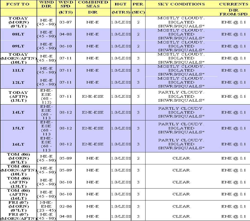
Weather Forecast for Phuket King's Cup Regatta
Synopsis: Latest satellite imagery shows areas of squalls moving w'ward across Far N'rn Malaysia, extending w'ward for some 80-90 nautical miles offshore across adjacent waters of the Andaman Sea and e'ward through much of the Central Gulf of Thailand. These squalls will move w'ward over the next 18-24 hours, moving across and north of Phuket and vicinity during that time.
The aforementioned squalls are associated with a broad west to east oriented trough of LOW pressure, which covers the S'rn Bay of Bengal, extending e'ward through N'rn Sumatra, much of Malaysia, and farther east across the South China Sea to N'rn Borneo. The trough will move very little over the next 2-3 days, with very little change in strength during that time. Latest satellite imagery shows a very weak surface LOW within the trough just off the North Central Coast of Borneo, which will weaken and dissipate as it moves w'ward toward the S'rn Malaysian Coast through the 06th.
Current Conditions: Local land observations show light and variable winds across Phuket and vicinity. Offshore winds over the past several hours have been from the NE-E at 10-15kts.
Severe Weather Potential/Advisories: Only a LOW risk of scattered squalls is likely across the race region over the next 2-3 days, with a minimal risk of severe weather likely during that time.
Conclusions: Gradients will remain very weak over the next 2-3 days, and these will only weaken further on the 06th as the aforementioned LOW (or is remnants) approach and pass to the south of the race region. Very little change is likely on the 07th as well as the aforementioned trough persists.
WINDS AND SEAS HIGHER IN SQUALLS
Hedge: Confidence in today's forecast is higher than average as NE-E winds persist, counterbalancing seabreeze effects for one more day.
However, confidence for the 06th/07th is slightly below average as the passage of the above-mentioned low (or its remnants) further reduces pressure gradients across the region. Within immediate coastal areas (within 01-02 nautical miles from shore), periods of SE winds are likely, mainly occurring during the late morning and afternoon (between 1000lt and 1600lt).
If you want to link to this article then please use this URL: www.sail-world.com/104396