
Predict Wind - Passage planning with PW tools
by PredictWind 2 Nov 2023 00:05 PDT
GMDSS Warnings © Predictwind
In the world of maritime navigation, having accurate and reliable weather information is paramount to ensure the safety of voyages, whether coastal or transoceanic. PredictWind, a pioneering company founded by Jon Bilger, 13 years ago, has been at the forefront of providing sailors and mariners with cutting-edge tools for weather forecasting, weather routing, and departure planning.
Today, we have the privilege of speaking with Nick Olson, who boasts nine years of experience with PredictWind and is an accomplished sailor, himself. Nick has a profound understanding of the PredictWind software and products, including the Iridium Go and Iridium Go Exec and their latest release, the Datahub which incorporates AI polars.
PredictWind's mission is clear: to keep people safe and empower them with accessible tools for obtaining accurate, high-resolution, professional weather forecasts. These tools are designed to be available anytime and anywhere, ensuring that sailors and mariners can make informed decisions before and during their passages.
One of the key features of PredictWind's software is weather routing, designed to provide sailors with a comprehensive view of their progression throughout their passage. Whether onboard a yacht, powerboat, or larger vessel, understanding where you'll be at any given time is essential for both safety and comfort. Furthermore, their Departure Planning feature assists users in identifying the best time to embark on their voyage. By comparing different departure dates, mariners can pinpoint favorable weather windows, ensuring a smoother and safer voyage.
So where to start when planning a passage?
By examining the bigger picture. This panoramic approach involves considering various factors and sources of information that can influence a successful crossing or passage, be it along the coastline or across vast oceans.
These initial assessments can include the consultation of pilot charts and forecast maps at a global scale, giving insights into prevailing winds, currents, and weather patterns for specific regions and times of the year, in addition to broader weather patterns, pressure systems, and disturbances that may impact your voyage. Having viewed this wider perspective, you are better equipped to determine a departure window. A four-day outlook is often considered a reasonable timeframe for assessing weather windows.
To refine the departure plan further, the Departure Planning feature considers essential parameters, including maximum and minimum wind speeds, estimated time of arrival, and potential discomfort indicators such as roll and vertical acceleration. Excessive roll and vertical acceleration can lead to seasickness, rendering crew members ineffective and potentially jeopardizing safety. Therefore, ensuring a departure time that minimizes these factors is crucial.
It's important to note that graphs within the PredictWind platform are intricately linked to weather routing, particularly within the Offshore App. They serve as visual cues for assessing various aspects of your route. For instance, you can monitor wind speed across different models and time periods. In the short term, typically spanning the next 12 to 24 hours, models tend to align closely in their predictions. However, as time progresses, you may notice increased divergence among the models, highlighting the need for regular weather updates via satcoms to ensure you always have the latest information at your disposal.
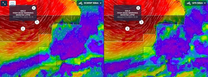
While reviewing this complex data, you may become aware of graphical GMDSS (Global Maritime Distress and Safety System) assist warnings. These warnings, generated by meteorologists, delineate areas of potential danger, such as gales and hazardous weather conditions. Identification of these warnings can ensure sailors steer clear of treacherous zones and make informed decisions about their route. Additionally, weather warnings, including data on roll, vertical acceleration, and gusts, offer critical insights into conditions that may be encountered during the voyage. It's essential to take notice of these warnings and adapt the departure plan accordingly, ensuring a safer and more comfortable journey. These warnings appear along your route when planning using the Predictwind tools.
What parameters should you look for in a comfortable passage?
Most sailors know the key indicators that could signal extreme weather, such as:
- Lightning Index
- Cape Index
- Rain Squalls
- Extreme Gusts
- Wind against current
When doing a quick check on the weather forecast, it is easy to miss these key indicators, which can often signal extreme weather, even when the averaged forecasted conditions are benign. To make sure you do not miss these extreme weather events, PredictWind have incorporated warnings automatically into their interface.
These unique set of parameters trigger weather warnings, which are highlighted throughout the platform with warning triangles. These can be clicked on for further information about the weather event and can be found within the Daily Briefing, the Forecast Tables, and the Weather Routing Maps and Weather Routing Tables.
Although these extreme weather warnings are automatic within the PredictWind interface, a good understanding of these parameters and when they are triggered can ensure you are identifying a weather window, best suited to you and your crew:
- Lightning Index; Any lightning value greater than 0 - The unit for lightning strikes is how many strikes per square 100kms surrounding your location. So any number above 0 could mean some lightning. The bigger the number, the greater the potential.
- Rain Squalls; If rain is 3mm/hour or more AND gust is 25 knots or more
- Thunderstorms; If (temp < 20deg) CAPE 1000+ triggers warning or if (20deg < temp < 30deg) CAPE 2000+ triggers warning or if (temp > 30deg) CAPE 3000+ triggers warning
- Extreme Gusts; if gust is 50% or more, greater than the 10 m wind speed
- Wind Chill; if wind chill is less than 8 degrees Celsius
- Fog; Any Fog value greater than 0.25 AND less than 0.75
- Fog and Rime; Any Fog value greater than 0.75
- Wind against current; When current direction and wind direction are less than 60 degrees apart (wind & current direction convention is opposite) & Wind is more than 12 knots & Current is more than 1 knot
While sailors might not typically focus on rain, it holds significance due to its association with volatile weather conditions, such as thunderstorms or high gusts. The average wind speed plays a pivotal role in weather routing calculations, with gusts not factored into the routing process. By considering rain alongside other variables like Convective Available Potential Energy (CAPE), you can gain a more comprehensive understanding of upcoming weather patterns and prepare accordingly.
Furthermore, the influence of waves will affect your boat's performance. Wave height and period data indicate how waves affect your boat's speed. A base polar speed of 100 signifies flat water with no wave-related impact. When this value deviates from 100, it demonstrates how waves either slow down or speed up your vessel, depending on whether you're sailing into or with the waves. A figure less than 100 shows how the boat is slowed by waves. A figure above 100 indicates the boat is pushed faster by the waves.
In addition to the parameters above, PredictWind has introduced some new conditions as part of their professional subscription, designed to maximize the comfort of the crew, such as:
- Roll; > 4 deg Roll
- Vertical Acceleration; > 0.2g's Vertical Acc
- Slamming Incidence; > 50% Slamming Inc
Roll is the root-mean-square (RMS) roll amplitude in degrees. When roll motions are large, moving around the boat and performing tasks becomes difficult. Objects not strapped down are likely to move. A roll RMS limit of 4 degrees is often used for safely moving around the boat and completing tasks and tends to be the largest in beam seas. For sailing yachts, which have a heel angle, roll is the change in heel angle due to the waves. Feedback from experienced sailors suggests that values above three degrees can already be quite uncomfortable. In such situations, safety measures and route adjustments become crucial considerations.
Vertical acceleration is the root-mean-square vertical acceleration in 'g's' (1.0 = Earth's gravity 9.81 m/s^2). Vertical acceleration is a good indicator of the potential for the crew to get seasick. The algorithm takes into account the primary, secondary, and tertiary swells to calculate the overall vertical acceleration for the boat. The higher the acceleration, the more likely the crew will get seasick. A vertical acceleration limit of 0.2g is often used for safely performing tasks and avoiding seasickness.
"Slamming Incidence" is the likelihood of experiencing at least one slamming event per minute. For monohulls, slamming is measured near the bow (10% LWL from the forward extent of the waterline). When this part of the boat emerges clear of the water, then impacts the water with a high relative vertical velocity, it is called a slamming event. For sailing catamarans, slamming is measured at the cross-deck structure (bridge deck), and again is based on relative vertical velocity. For either monohulls or catamarans, a slamming incidence of 50% is considered excessive and may lead to hull damage or injuries to the crew.
With the PredictWind tools, you have the choice between optimizing for the fastest route or prioritizing comfort. While some may favor comfort, often for reasons such as adhering to specific departure times or avoiding unfavorable weather conditions, a word of caution is in order. Opting for the comfort setting can sometimes lead to routes that significantly deviate from the direct path, taking you far from your intended course to evade adverse conditions. Most sailors tend to lean towards the fastest route as a primary choice, inserting waypoints to bypass specific weather systems or establish boundaries to skirt particular areas, should they encounter conditions they wish to avoid. Your settings are entirely personal preference, based on your preferred level of comfort, speed, and skill.
So, how does PredictWind 'predict' where your vessel will be in relation to changing weather systems along your route?
PredictWind employ what are known as "polars". Polars represent how fast your vessel can travel in various weather conditions.
Setting up your boat's polars is essential. You can do this through the PredictWind app or through the Forecast website. If you're unsure about your boat's performance under different conditions, you can choose from predefined polars for various boat types. Alternatively, you can manually input your boat's anticipated speeds under specific wind speeds and angles. Remember that the aim is to fine-tune your polars to match your vessel's performance as closely as possible. If you're cautious during night passages and prefer to sail slower, you can adjust your polar to reflect this. Nighttime sailing may involve having a smaller crew on watch, so a slower pace is good practice. PredictWind can automatically adjust your polar speeds at night to provide a more accurate route prediction.
Additionally, you can set depth constraints to avoid routing through shallow waters. While this doesn't replace navigation skills, it enhances route accuracy.
Following this, you will need to configure your wave polars. The significance of this lies in enabling the software to construct a hydrodynamic model of your vessel. This model offers insights into how your boat will respond to varying wave states along your route. At sea, you'll encounter not just one type of wave; you'll contend with wind waves, and swell (primary, secondary, and tertiary), which all affect your vessel in different ways. This information can be critical for your departure planning and ongoing voyage. It enables you to make informed decisions about whether to proceed or delay your voyage.
PredictWind's latest feature, AI Polars alongside their Datahub, optimizes weather routing based on your boat's real-time data combined with your distinctive sailing habits. By understanding your boat's behavior in all wind and wave conditions, the AI Polar automatically adjusts to give you even more accurate routes.
This feature is as easy as plugging in the PredictWind DataHub to your boat's instruments and activating AI Polars. The technology captures and interprets vital data points like boat speed, wave conditions, true wind speed, and true wind angle with hydrodynamic modeling intricately predicting your boat's movement. In addition, the weather routing predicts the performance effect of the waves on the routing, offering the most precise routing output available.
Irrespective of the weather platform you choose to use, it is important to wholly understand and be able to interpret the data available for the safety and comfort of your crew.
You can find various webinars on the full features of PredictWind and how you can fully utilise them in your route planning at www.predictwind.com.