Hurricane Irma - Warnings issued for parts of Florida
by Weather.com on 8 Sep 2017
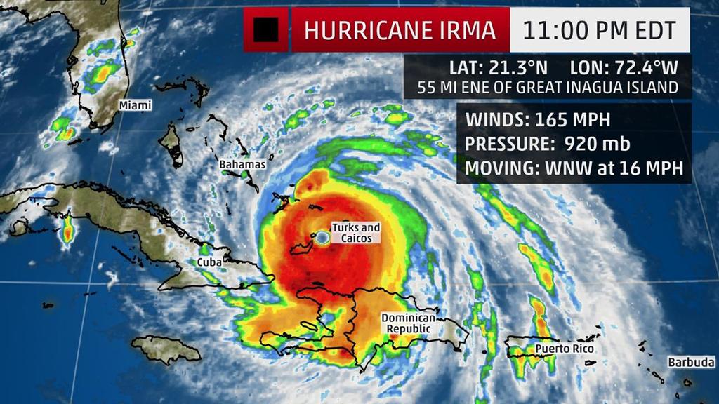
Current Storm Status - The highest cloud tops, corresponding to the most vigorous convection, are shown in the brightest red colors. Clustering, deep convection around the center is a sign of a healthy tropical cyclone. The Weather Channel
Hurricane Irma, a potentially catastrophic Category 5 hurricane, is currently pummeling the Turks and Caicos and will then head for the Bahamas before making a potentially devastating strike on Florida this weekend. Irma may also pose a serious threat to portions of Georgia and the Carolinas.
(More:
Hurricane Central |
Impacts In Caribbean)
Below is everything we know about Irma right now, including its latest status, along with potential forecast impacts in the U.S. and the Caribbean Islands.
Irma's Latest Status, Timing
The center of Irma is located about 55 miles east-northeast of Great Inagua Island and is moving west-northwestward at about 16 mph. Irma's maximum sustained winds are at 165 mph based on data from NOAA and Air Force Hurricane Hunter aircraft, after being steady at 185 mph for an astounding 35 hours. Irma is now tracking through the Turks and Caicos and has its sights set on the southeastern Bahamas.
(More:
Irma's Notable Extremes)
Hurricane warnings have been issued for Florida's Jupiter Inlet southward around the peninsula to Bonita Beach, the Florida Keys, parts of the northern coast of Haiti, the southeastern, central and northwestern Bahamas, the Turks and Caicos Islands and the Cuban provinces of Camaguey, Ciego de Avila, Sancti Spiritus and Villa Clara.
Additionally, a tropical storm warning is in effect for the coast of Haiti from south of Le Mole St. Nicholas to Port-Au-Prince. A tropical storm warning is also in effect for the Cuban provinces of Guantanamo, Holguin and Las Tunas.
A hurricane watch is also in effect for portions of Florida, from north of the Jupiter Inlet to Sebastian Inlet, as well as north of Bonita Beach to Anna Maria Island, along with the Cuban provinces of Guantanamo, Holguin, Las Tunas and Matanzas.
A storm surge warning has also been issued from the Jupiter Inlet to Bonita Beach and the Florida Keys. A storm surge watch is in effect from north of the Jupiter Inlet to Sebastian Inlet and from north of Bonita Beach to Venice.
Low wind shear, increased mid-level moisture and increasing oceanic heat content favor that Irma will remain a powerful hurricane (Category 4 or stronger) for the next several days, though some intensity fluctuations are likely at times. At this intensity, small deviations in wind speed will not change impacts. A direct hit will be catastrophic.
For the next couple days, Irma will move west-northwest on the south side of a ridge of high pressure called the Bermuda high, centered in the central Atlantic.
(Interactive MAP: Track Irma)
By this weekend, Irma will begin to turn north in the direction of a departing southward dip in the jet stream that has set up in the eastern United States. The location of that northward turn will dictate where the most severe impacts from Irma occur in Florida and the southeastern United States.
Confidence is growing that southern Florida will likely see severe hurricane conditions starting this weekend. Major impacts could then spread through the rest of the Florida Peninsula, Georgia and the Carolinas.
Here's a general overview of the timing for impacts from Irma into next week.
Potential Impact Timing:
• Turks and Caicos: Into Friday
• Bahamas: Friday-this weekend arriving from east to west; hurricane-force winds will spread into the central Bahamas by early Friday morning
• Cuba: Friday-this weekend arriving from east to west; hurricane-force winds may arrive by late Friday afternoon
• Florida: Saturday-Sunday; hurricane-force winds may arrive in South Florida and the Florida Keys by late Saturday.
• Georgia-Carolinas: Late Sunday-Monday
U.S. Forecast: Destructive Impacts Possible in Florida, Georgia and the Carolinas
While it is still too soon to narrow down specifics on the exact path of Irma's center and eyewall, it is becoming likely that a major hurricane strike on at least part of South Florida, including the Florida Keys, will happen this weekend.
(Latest News: 650,000 Ordered to Flee Miami-Dade in County's Largest Evacuation Ever)
According to the latest National Hurricane Center's forecast, the center of Irma will be very close to South Florida by early Sunday morning, with conditions going downhill already during the day on Saturday.
Depending on the exact track of Irma, locations in the hurricane warning in southern Florida could see devastating to catastrophic impacts, including structural damage and widespread power and communication outages. The National Weather Service said that areas in the hurricane warning could be uninhabitable for weeks or months.
A life-threatening water-level rise of 5 to 10 feet above ground level is possible in southern Florida if peak surge coincides with high tide on Sunday. If you are told to evacuate a coastal location, please do so as instructed.
By Monday, the possibilities range from the center of Irma being located near or off the Southeast coastline to being inland over southern Georgia.
Irma's wind field is very large. Hurricane-force winds extend outward up to 75 miles from the center, and tropical-storm-force winds extend outward up to 185 miles.
Therefore, dangerous surf and coastal flooding will likely exist throughout the southeastern U.S. coastline even well away from Irma's center this weekend into early next week. The magnitude of any storm-surge inundation along the Southeast coast will depend on the track of Irma.
Significant wind damage and rainfall flooding could occur in parts of Georgia and the Carolinas, as well.
All residents in the Florida Peninsula, Georgia and the Carolinas should monitor the progress of Irma closely.
For more detailed information on possible impacts in Florida, Georgia and the Carolinas, click here.
Forecast: Hispañiola, Turks and Caicos, Cuba, Bahamas
Irma will pass near Hispañiola, the Turks and Caicos, the Bahamas and Cuba into the weekend as a major hurricane.
To read in full and to keep an eye on the weather for more information.
(More: Beware 'I' Hurricanes)
If you want to link to this article then please use this URL: www.sail-world.com/157080