Volvo Ocean Race- Chris Nicholson on the Team Vestas Wind disaster - 1
by Richard Gladwell, Sail-World.com on 16 Dec 2014
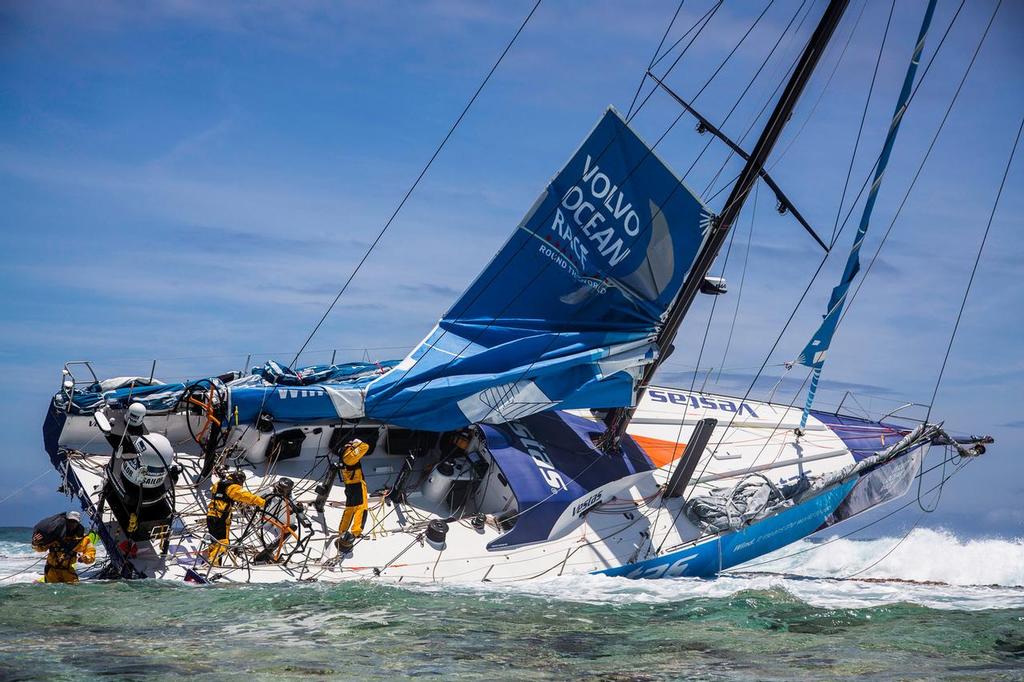
Team Vestas Wind’’s boat grounded on the Cargados Carajos Shoals, Mauritius, in the Indian Ocean. In this image, the crew head back to the boat to retrieve everything they can; including ropes, diesel, Inmarsat dome and sails. Brian Carlin - Team Vestas Wind
Part 1 of three part, 80 minute, interview with Team Vestas Wind skipper, Chris Nicholson on the wrecking of the Volvo Ocean Race yacht on an idyllic atoll in the South Indian Ocean during the night of November 29. In this part, Nicholson discusses the factors leading up to hitting the reef, interspersed with other research information, charts, video and images. Parts 2 and 3 will follow on consecutive days.
'I made a mistake' was Wouter Verbraak's very honest admission to accusations from the Armchair Admirals, a week after the wrecking of Volvo Ocean Race entry, Team Vestas Wind in late November.
The Dutchman's courageous words were highly unusual in a sport noted for its Codes of Silence at the first sniff of a catastrophe.
Verbraak was navigator on board the Danish flagged Volvo 65 which rammed into reef off the Cargados Carajos Shoals 200 nm from Mauritius in the Southern Indian Ocean at a speed of almost 20kts.
The highly credentialed navigator made his very honest admission in a media conference, held in Abu Dhabi, venue for the finish of the second leg. 'In hindsight we would have continued to zoom in on the area much more on the electronic charts. Not doing so was the big mistake I made.'
Team Vestas Wind struck the reef off an idyllic atoll, named St Brandon, in the first hour of the night ten days into the second leg of the 40,000nm Volvo Ocean Race. The hazardous area is described in one Pilot guide as being too dangerous to approach from the seaward (eastern) side, the track taken by the yacht and her nine crew.
'The Shoals have been reported to lie about 3 miles further south west than charted,' the NGA's Pilot handbook for the area says. 'The eastern side of the reef has not been closely examined, because it is almost impossible to approach it from the East, in addition to the tremendous sea always breaking over it, is reported to be steep-to, and, therefore, most dangerous to approach under any circumstance.'
In what proved to be the final move of her race, Vestas Wind entered the area of the Shoals from the direction warned against by the Pilot, an hour after nightfall, and having just cleared a rain squall which further restricted any visibility of the low lying archipelago that lay ahead.
Backed by a Denmark based Vestas Wind Systems, the world leader in wind energy, Team Vestas Wind was one of the seven identical yachts, supplied by the Volvo Ocean Race organisers. The team was the last to enter the round the world race, which is in its 12th edition, and now stops at nine ports on a three yearly cycle.
Vestas Wind did not have the same work up time as the other race teams. She was launched in the third week of August and only completed her 2000nm qualifying voyage en route from Southampton to the race start port of Alicante in Spain.
She’d performed well enough in the first leg despite expected teething problems and was unlucky to miss out on third place in Cape Town, which would have set her up nicely for the remainder of the race.
Late course changes:
Leg 2 was one of the most vexed for race organisers. Due to the threat of attack by Somali based pirates, No-Go or Exclusion Zones, had been established to keep the boats well away from the Somali pirates and their attendant motherships.
Race organisers made a further course change the night before the start of Leg 2, issuing a change to the course to create an escape route from the path of an expected tropical cyclone. The edge of the exclusion zone was moved closer to the African coast, allowing the boats to sail a more direct course to Abu Dhabi and pass inside Cargados Carajos Shoals.
'There was a change made the evening before the leg start,’ said skipper Chris Nicholson, a four race veteran who had skippered the Emirates Team New Zealand crewed Camper to second place overall in the 2011-12 Volvo Ocean Race.
The Australian, a three times World Champion, and top skiff sailor in addition to his impressive round the world race credentials, had been skipper designate of a Team New Zealand crew in this race. A late decision by the Kiwi team to focus solely on the 2017 America’s Cup, left the crew without a ride. Along with two other Team NZ crew members, the trio had 12 round the world races between them, with one having first competed 30 years ago.
'That change allowed the Shoals to be within our sailable course. There had been some discussions, and everyone had their eye on the tropical storms. The thinking was that if the Exclusion Zone was widened out then it would be easier to deal with those storms if they eventuated.
'We were surprised that the weather could be worked out eight days with a degree of certainty, but we thought the cyclones were a real possibility. If you want to go around a tropical storm, in this area, you go around it to the west,' Nicholson explained.
That course would take them closer to the African coast and through the area of the Shoals. Without the change in the Exclusion Zone, the crews would have been forced further east and into unobstructed ocean.
'You go west, rather than going upwind', he explained. 'Before the change, the Shoals were excluded. You couldn’t go near them. We had to stay further to the East.'
'We got the official course change notice the night before, and I sent it onto Wouter. He had to look at that, and the next morning when we were at work, he showed where the new Exclusion Zone limits were.
'Our planned route changed just before we left,' said Verbraak on his Facebook page a week after the incident. 'With the focus on the start and the tricky conditions, I erroneously thought I would have enough information with me to look at the changes in our route as we went along. I was wrong. I am not trying to make any excuses – just trying to offer up some form of explanation and answer to some of your questions.'
'I did check the area on the electronic chart before putting my head down for a rest after a very long day negotiating the tropical storm and what I saw was depths of 42 and 80m indicated,' Verbraak added.
'We were sailing right on our routing,' says Nicholson, fast forwarding ten days to describe the last hour before Vestas Wind hit the reef off St Brandon.
'We wanted a course of between 355 and 010 (almost a due North average), in those hours prior to hitting the reef. And that was the course that we did sail.
'The reason we hit the reef was because we believed there was a minimum depth of 40 metres. But, in fact, there was a small island in our way. That is the tragic part of this.
'We hit the SE corner of the atoll.
'When I looked a couple of days previously, Wouter showed me seamounts over where our course was. At the extreme, the water depth went from 3,000 metres to 40 metres.' (Away from the Shoals the water depth is 13,000 metres).
Dongfeng has near miss with same reef
Other teams also struggled with navigation in the Cargados Carajos Shoals area. One is reported to have been just a mile away from suffering the same fate as Team Vestas Wind.
The previous race boat through the area, the Chinese flagged entry Dongfeng Race Team, sailed by a mostly Chinese and French crew, wrote of their passage: 'Charles (Caudrelier – skipper) had noticed this archipelago a few days ago. But it’s worth noting that it’s pretty hard to find. In fact, to see it on our electronic charts, you have to zoom right in on top of it. But how and why would you zoom into it if you don’t know it’s there in the first place?'
Race leader Abu Dhabi Ocean Racing, also reported a wake-up call, as they passed to the west of the Shoal Zone. 'When we went past there we said how easy it would be to hit it at night. Fortunately, we went through there in the daylight. It is very difficult to see it with the electronic charts, and of course at night you wouldn’t see it at all', wrote skipper Ian Walker.' Prophetic words.
'We had been talking about these reefs for some time, so we were already pretty nervous about it,' noted Team Alvimedica navigator Will Oxley, who was in the same area but to the west of Team Vestas Wind, at the time she rammed into the reef.
Drilling down on the electronic charts
What the navigator saw: Level 1 - No terrain
Level 2 - No terrain
Level 3 - Atoll and Reef only now visible
At a higher level the chart only shows contour lines in the Cargados Carajos Shoals area. There is no indication that there is terrain above the water, except for one island name on the chart Ile Raphael (some distance away from St Brandon). Zooming into the next level on the chart two areas of blue shading are shown - (being reefs and a lagoon). A small brown shaded area is discernible. Drill down one level further, and the brown shading materializes into a series of elongated islands or atolls, still shaded in brown, but surrounded by a substantial reef and lagoon. One wreck is shown on the electronic chart inside the lagoon.
This view is the one Verbraak missed.
Verbraak says he did not drill down on the chart to the low level, and consequently did not see the fathom lines and seamounts, on the electronic chart, suddenly morph into land and lagoon surrounded by a reef, which would have started the mental alarm bells ringing.
'We didn’t see any island name. We believed the minimum depth was 40 metres,' Nicholson told Sail-World.com.
'We do have paper charts on board, but I hadn’t seen them being used. I would have looked at the paper charts only if the navigator were looking at them. That is part of the passage planning together. Passage planning is out of my skill area. I would be wasting time to do passage planning to that level compared to Wouter’s skills.'
Course change set up collision
Nicholson says Verbraak normally reviewed the course on Google Earth as part of their leg preparation. But the satellite image application is not available on board the race yachts. Google Earth very clearly shows the Shoals and above water terrain without having to zoom in on a particular section.
'There was a slight course change a couple of hours before impact', says Nicholson, when we changed from the A3 to the fractional Code Zero, because we were leaving the tropical storm and we were on a slow and gradual header on port tack. We wanted to maintain a heading of roughly due North.
'That was the reason for our slight course change; (which put them on a collision course for the reef) it had nothing to do with seamounts or the like. We believed there was 40 metres of depth there – and that is the mistake we made.'
Nicholson says they weren’t aware of having to steer clear of any islands, reefs or atolls. 'We thought we could go straight through. Forty metres of water is perfectly acceptable to go over a seamount. The conditions were light to moderate at worst. There was no wind chop at the time. When we had looked at it in the days before, Wouter had said the current was negligible.
'The days before I had some concerns about it because we had bumpier water going over seamounts. But when we discovered that the depth was 40 metres and no current, then it is OK to go across.
'I would have expected to see very little change in the sea-condition going over seamounts at a depth of 40 metres.'
'I didn’t see Wouter looking at the Pilot for the area,' says Nicholson. 'But that doesn’t mean that he did not refer to it.'
Nicholson said their main reference for any area was to use the electronic charts, than having the Pilot or paper charts open in the navigation area.
As noted earlier, the Pilot handbook for the area notes that the location of the extensive group of reefs, islets and shoals could lie three miles to the SW of where they have been reported on the chart. The date of the last survey on which the charts are based (electronic and paper) is unknown however could be around compiled from surveys between 1825 and 1896).
The final minutes
Just before dark, Nicholson says the swell was 1-2 metres; wind-chop was virtually nil. 'We’d had several rainsqualls, so it was reasonably smooth sailing. The wind was about 15kts.'
Just before impact Nicholson says he moved over to the port or windward side when the other crew said they could see a bit for of a reflection or whiteness to windward. Vestas Wind ran a watch system of three on deck at any one time. Nicholson says he was on and off watch. The navigator was asleep at the time, along with four other sailing crew.
'Our race strategy was that if there was something we had to navigate around, both of us would be up always. If there is nothing to navigate around, or there is something that you can sail over the top, then we just handle it the same as any other deep part of the ocean.
'In the first instance, our roles would be that Wouter would be in the navigation station, and I would be on deck helping manage the on deck situation. On deck, we have a chart plotter in the centre tunnel, just inside the hatch. We have been primarily using that as an AIS tracker to see other vessels. There is a deck screen as such, but it doesn’t get used much.
'We’d just popped out from under a rain squall. I’m not sure if someone said, 'moonlight', or what. There was an indication it could have been a tideline. At that time, I had said we were going over the Shoals at a minimum depth of 40 metres.
'In hindsight the white reflection was obviously waves breaking, but it looked like moonlight on the water, with the shadow of a cloud on one side. We couldn’t see or hear anything that was an indication of the reef being there. If we had known, obviously we’d have reacted straight away. There was no visual indication or noise of what was about to happen.
'The impact was the first indication I had of shallow water or breaking waves.
'We were in surf straight away. I could look out the starboard side and see exposed rocks and breaking waves.'
'The reef is 1.5-2miles from the sandy beach that surrounds the atoll. Where we hit was obviously hard rock and then it goes into soft coral in the lagoon, before hitting the sand.'
Nicholson says that when they hit he assumed the worst.
For Part 2 click here
Catch Part 3 on Thursday.
For a more detailed analysis and explanation of the navigational issues in this immediate area click here
It must be emphasised that the crew of Team Vestas Wind believed they were sailing in an area of clear water, 40 metres deep, and were not making a racing rounding of the atoll and Shoals, or were off course as this otherwise excellent commentary implies.
It should also be noted that armchair navigators have far better facilities at their disposal than the race yachts. The competitors run a 'fat client' navigation platform, meaning that all the course and weather computing is done on board, based on a common weather data feed supplied to all race yachts by the organisers. That weather data is used to drive the optimised course routing which trades off distance sailed against best possible boatspeed, and predicted weather en route.
At home, race fans run a 'thin client' system based on high speed internet connections which can access all manner of applications and information. They have vastly superior high-speed access to information not accessible to those on board the race yachts, but don't usually have the same navigation facilities and software applications.
Professional weather routers, usually top navigators in their own right, combine the best of both worlds, and are allowed to advise competitors in some short-handed trans-oceanic races, but are not permitted in the Volvo Ocean Race.
If you want to link to this article then please use this URL: www.sail-world.com/129959