Red Alert - Great Britain's gales continue
by Sail-World.com on 13 Feb 2014
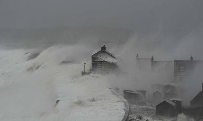
Huge waves approach the three-storey Cove House Inn at Chesil Beach in Dorset KNS News
http://www.sell-story.co.uk/
The fast moving Atlantic winter jetstreams have brought a succession of winter gales to the British Isles and now a rare Red Alert as winds intensify.
Remember that during the London Olympic Games, that the Australian Sailing Team adopted the Cove House Inn as their watering hole.
The Sail-World Team was amongst the thousands who celebrated Australia's three Golds and one silver at the Cove. Well this is what its looked like in recent days...
Here is the latest met office weather:
Red Warning of Wind:
Dates:
Issued at: 1027 on Wed 12 Feb 2014
Valid from: 1330 on Wed 12 Feb 2014
Valid to: 2100 on Wed 12 Feb 2014
Warning: During this afternoon a swathe of exceptionally strong winds is expected to affect western parts of Wales and then some northwestern parts of England this evening, particularly in coastal areas. Winds are expected to gust 80 mph widely and possibly reach 100 mph in the most exposed locations in west and northwest Wales.
Winds of this strength can cause widespread structural damage, bringing down trees and also leading to loss of power supplies. In addition, large waves are likely to affect some coasts. The public should take action to alter their travel arrangements during this spell of storm force winds.
Chief Forecaster’s Assessment: A vigorous area of low pressure is expected to move northeastwards across Ireland and southern Scotland this afternoon and evening. Damaging winds are likely to develop along the southern flank of this area of low pressure, especially in coastal locations.
Coastal areas of west Wales and northwest England are likely to bear the brunt as southwesterly (later westerly) winds widely gust to 80 mph and possibly 100 mph in the most exposed locations. The core of strongest winds will then affect parts of the coast of north Wales and northwest England early evening with peak gusts of 85 mph.
Amber Warning of Wind:
Dates:
Issued at: 1515 on Wed 12 Feb 2014
Valid from: 1520 on Wed 12 Feb 2014
Valid to: 2350 on Wed 12 Feb 2014
Warning: A vigorous area of low pressure will move northeastwards across northern parts of the UK later on Wednesday, clearing eastwards early on Thursday. This is likely to be accompanied by a swathe of southwesterly gales across many areas which may be severe in places. Winds will veer more westerly later on Wednesday.
The main swathe of very strong and potentially damaging winds now affecting parts of Wales will move northeast to affect Northern Ireland, the northwest Midlands, northern England and fringing into southern Scotland later this evening. Gusts of 70 mph are likely widely in the Amber warning area, with 80 mph on exposed western coasts (this warning should be viewed in the broader context of the Red and Yellow Wind warnings).
The public should be prepared for the the risk of disruption to transport and possibly also power supplies. In addition, large waves are likely to affect some western coasts.
Chief Forecaster’s Assessment: The worst of the winds associated with the active frontal system will clear the far southeast of England soon after 1600 hours today. However, the main swathe of very strong winds on the southern side of the deep depression now across Wales will move northeastwards across northern England, Northern Ireland and into the far southwest of Scotland this evening, before easing from the south overnight.
Yellow Warning of Rain:
Dates:
Issued at: 1218 on Tue 11 Feb 2014
Valid from: 0900 on Wed 12 Feb 2014
Valid to: 2100 on Wed 12 Feb 2014
Warning: A further spell of widespread rain, heavy in places, is likely to spread northeastwards across much of the UK on Wednesday clearing eastwards from southern areas on Wednesday evening. Following earlier heavy rainfall, the public should be aware of the potential for further flooding in places.
Gale or severe gale force winds are likely to be an added hazard in places (see separate warnings).
This is an update to the Alert first issued on Sunday.
Chief Forecaster’s Assessment: Another Atlantic depression is expected to bring a spell of heavy rainfall and very strong winds to parts of the UK on Wednesday. Southern and western parts of England and Wales look most likely to see further heavy rainfall. Some 15-25 mm of rain are likely within the warning area with a risk of 40 mm on high ground of south Wales and southwest England - much of this within a 12 hour period. Falling soon after earlier widespread rainfall, the cumulative effects of these weather systems are likely to exacerbate the current flooding situation.
Yellow Warning of Snow:
Dates:
Issued at: 1144 on Wed 12 Feb 2014
Valid from: 1200 on Wed 12 Feb 2014
Valid to: 1000 on Thu 13 Feb 2014
Warning: Bands of rain, sleet and snow will affect central and northern Scotland during the rest of Wednesday and into Thursday morning. Snow levels will vary through the period, but there is a risk of 2-5 cm accumulating above 300 metres and a further 10-15 cm above 400-500 metres.
The public should be aware of the potential for some travel disruption and difficult driving conditions.
Chief Forecaster’s Assessment: A vigorous area of low pressure will continue to move northeast across the UK during Wednesday. The leading edge of the precipitation associated with this system will engage the cold air already established across Scotland with snow falling here. As the system moves northwards, less cold air arrives with the snow turning to rain for a time, although remaining as snow above 500-600 metres in Scotland. However, on Wednesday evening and into Thursday as the low system moves away eastwards colder air will again be pulled into Scotland allowing the precipitation to fall as snow once more.
Yellow Warning of Wind:
Dates:
Issued at: 1531 on Wed 12 Feb 2014
Valid from: 1535 on Wed 12 Feb 2014
Valid to: 0500 on Thu 13 Feb 2014
Warning: A vigorous area of low pressure will move northeastwards across Ireland and southern Scotland during Wednesday afternoon and evening, clearing eastwards early on Thursday. This will be accompanied by a swathe of southwesterly gales across many areas which will be severe in places. Winds will ease from the south overnight.
A first peak in the winds will clear from southeast England late afternoon, but with the main swathe of even stronger and potentially damaging winds now across Wales, then affecting Northern Ireland and northern England later in the day (see Amber and Red warnings).
The public should be prepared for the the risk of disruption to transport and possibly also power supplies. In addition, large waves are likely to affect some coasts.
This warning has been updated to include all of Northern Ireland and southern Scotland.
Chief Forecaster’s Assessment: A vigorous depression will track across the north of Ireland during Wednesday afternoon and hence over southern Scotland by late evening. Squally winds will soon clear southeast England, then a swathe of very strong winds will affect west Wales during the afternoon and parts of north Wales, Northern Ireland and northern England during the evening (see Amber and Red Warnings), with winds also gusting to 70 mph across parts of southwest England and the Midlands at first. Winds will ease from the south overnight.
Yellow Warning of Snow:
Dates:
Issued at: 1200 on Wed 12 Feb 2014
Valid from: 2100 on Wed 12 Feb 2014
Valid to: 1000 on Thu 13 Feb 2014
Warning: Rain will turn to snow over the high ground of northern England and southern Scotland later on Wednesday evening, becoming showery overnight into Thursday, with a risk of some snow to lower levels later. Accumulations of 1-3 cm of snow are possible above 150-200 metres and 5-10 cm above 300 metres. Combined with severe gales (see separate warnings), blizzards are likely to affect higher level roads.
The public should be aware of the risk of disruption to travel.
Chief Forecaster’s Assessment: A vigorous area of low pressure will continue to move northeast across the UK during Wednesday, with colder air being pulled westwards across most parts during Wednesday night, such that precipitation will turn to snow down to relatively low levels by Thursday morning. However, most accumulating snow will be above 200-300 metres, with possible blizzards for a time on the high ground of northern England and southern Scotland.
Yellow Warning of Ice:
Dates:
Issued at: 1610 on Wed 12 Feb 2014
Valid from: 0015 on Thu 13 Feb 2014
Valid to: 0900 on Thu 13 Feb 2014
Warning: A mix of rain, sleet, snow and hail showers are likely at times overnight, whilst some temporary slight accumulations of snow are possible on ground above 200-300 metres.
With road temperatures falling to around zero inland, the public should be aware of the risk of ice, chiefly over high ground, but also locally to lower levels where hail showers occur.
Chief Forecaster’s Assessment: A cold and showery westerly airstream will become established across England and Wales during Wednesday evening, with the showers turning to a wintry mix overnight. Heavy showers of hail may lead to a temporary covering of hail at lower levels, whilst localised accumulations of 1-3 cm of snow are possible on roads above 200-300 metres.
If you want to link to this article then please use this URL: www.sail-world.com/119225