Nv charts Announces Region 3.1 Chart Set for Rhode Island
by Mike Martel on 20 Jun 2013
Rhode Island- n.v charts
One of the most popular boating and cruising areas on the U.S. East Coast, the region from Long Island, New York to Nantucket, is now available in improved format and readability from nv charts, a global leader in highly accurate, detailed maritime chart products.
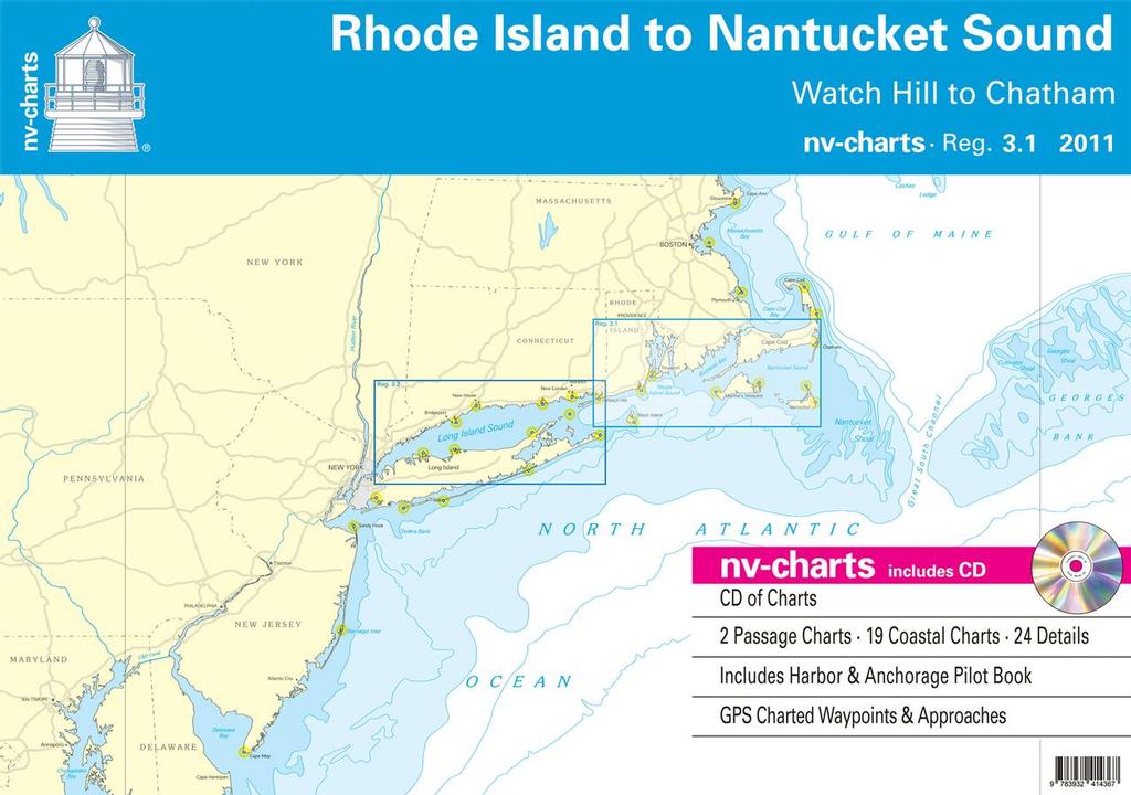
Region 3.1: Rhode Island to Nantucket Sound, including the waters from Watch Hill, R.I. to Chatham, Massachusetts, on the lower end of Cape Cod, includes Nantucket, the Elizabeth Islands and Buzzard’s Bay, Block Island and Block Island Sound, and all of Narragansett Bay. This chart set will be a delight to ‘gunkholers’, since the smallest state in the Union, Rhode Island, still has more than 400 miles of coastline altogether.(Newport, Rhode Island, USA)
The nv charts Region 3.1 set is provided in paper and digital format for sailors, motor boaters, fishermen and professional mariners, and cruising enthusiasts. It includes two passage charts, plus 19 coastal charts and 24 detailed areas (harbors and anchorages) all in a manageable set that is designed to fit neatly on a chart table and includes a CD with all the charts in digital format, GPS charted waypoints and approaches, and a handy and very useful Harbor and Anchorage Pilot Book. This chart set is based on NOAA data with a new layout, clear cartography and international chart standards.
nv charts offer unique features not found in other traditional NOAA chart sets, e.g., more distinctive shore and shallows cartography, aids to navigation and light characteristics, tidal information, and even four helpful pages in the back outlining symbols, legends, and other data that help the navigator interpret the information in the chart. The cartography is visually distinct; unique color differences make specific depths, shoals, reefs, exposed tidal areas stand out for quick, easy recognition. Also, lighthouses illustrate their light characteristics for better identification. Legend pages at the back of the set provide a guide to symbols, legends, and other data that help the navigator interpret the information in the chart.
Region 3.1 charts in digital format are also available on SD memory cards for chartplotters including Lowrance, Simrad, and B and G chartplotter systems, and are compatible with all instruments in the Lowrance HDS Series, Gen. one and two; Simrad NSE, NSS, and NSO systems; and all B and G Zeus series systems.
The chart sets retail at $69.95 USD and can be purchased online
website or from local chandleries and marine supply stores. It can be combined with Region 3.2, which includes all of Long Island Sound, at a combination discount.
nv charts produces charts for mariners in paper, digital format for use on PCs, and in formats compatible with mobile devices. nv charts are also supplied on SD memory cards for chartplotters, and include all current nv-chart regions, e.g., the U.S. East Coast, Europe, the Caribbean and Cuba. For more information, visit
website
About nv charts
nv charts began producing charts for navigation in Germany some 30 years ago. nv charts are used by cruisers, racers, the Baltic-Kiel-Pilots, and the US Coast Guard. US regions are based on NOAA and other data with the company’s own additional surveys and supplemental cruising information. nv charts produces about 600 charts and over 1000 details and harbor plans. These charts are designed with the prudent mariner in mind; coasts and anchorages are regularly updated through new surveys and aerials. Having charted harbors, checked georeferencing points, and double-checked buoys and lighthouses, nv charts offers the newest cartography in both paper and digital format. For more information, and online ordering, visit
website
If you want to link to this article then please use this URL: www.sail-world.com/111043