Irma's march now threatens Tampa Bay
by Weather.com on 11 Sep 2017
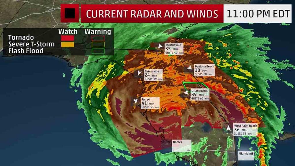
Current Wind,Radar, Watches and Warnings The Weather Channel
Hurricane Irma is moving northward along Florida's spine following its second landfall in the Sunshine State, unleashing its feared, devastating strike after it became the strongest to landfall near Key West in 57 years.
(Full Coverage of Irma:
Hurricane Central)
Most worrisome is the anticipated storm surge as Irma's center of circulation moves gradually up the coast, turning what had been offshore winds and abnormally low water levels into a prolific, life-threatening storm surge.
The worst storm surge in Tampa Bay and the Gulf Coast is yet to come.
(More:
Why the Water Retreated From Florida Bays Before Irma's Storm Surge Arrived)
Irma's Latest Status, Conditions
The center of Irma is located about 50 miles southeast of Tampa, Florida, and is moving just west of due north at 14 mph.
(More:
Irma's Notable Extremes)
As the eyewall moved through Naples late Sunday afternoon, a wind gust to 142 mph was reported.
A gust to 130 mph was clocked at the Marco Island Emergency Operations Center.
Wind gusts up to 109 mph have been clocked in the Miami/Ft. Lauderdale metro.
A construction crane boom and counterweight collapsed over a building under construction in downtown Miami near Biscayne Boulevard.
(Track Irma:
Current Weather Conditions and Webcams)
Other notable wind gusts so far:
• North Perry Airport (Broward County): 109 mph
• Miami International Airport (tower observation): 99 mph
• St. Lucie Nuclear Power Plant: 99 mph
• Ochopee: 92 mph
• Coral Gables: 90 mph
• Fort Myers (Southwest Florida International Airport): 89 mph
• Marathon Key: 88 mph
• Deerfield Beach: 86 mph
• Miami-Opa Locka Executive Airport: 84 mph
• Juno Beach: 83 mph
• Miami NWS/NHC office: 81 mph
• Tampa Bay: 78 mph
• Clearwater Beach: 78 mph
• West Palm Beach International Airport: 77 mph
• Fort Lauderdale/Hollywood International Airport: 75 mph
• Port Charlotte (Charlotte County Airport): 74 mph
Farther north, a gust to 62 mph was clocked at Vilano Beach, Florida, on the Atlantic side. A home reportedly lost shingles and siding in Flagler Beach. At least one tree was downed in St. Simons Island, Georgia.
Storm surge at Virgina Key, in Biscayne Bay, was close to 4 feet above normal tides Sunday afternoon. At Naples, in the Gulf of Mexico, storm surge topped 4 feet above normal tides early Sunday evening.
Water had been reported to top the sea wall in Palm Coast, Florida, and a break in the dune and overwash was reported at Malacompra Park, also in Flagler County.
Hurricane and Storm Surge Watches and Warnings
A storm surge warning has been issued from the South Santee River southward to the Jupiter Inlet, and on the peninsula from North Miami Beach to the Ochlockonee River, including the Florida Keys and Tampa Bay.
(Interactive:
How Much Storm Surge May Occur)
The first bit of good news is that some hurricane warnings have been downgraded to tropical storm warnings in south Florida.
Hurricane warnings extend north of Jupiter Inlet on the east coast to Fernandina Beach and from Bonita Beach to Indian Pass on the Gulf Coast. Hurricane warnings are also in effect well into southern Georgia. Included in the hurricane warnings are the Tampa/St. Petersburg metro, Jacksonville, Tallahassee, Thomasville and Valdosta.
Hurricane warnings mean hurricane conditions are either occurring or expected to occur within 36 hours.
A hurricane watch is also in effect for the Georgia coast northward to Edisto Beach, South Carolina. A watch means hurricane conditions are possible within 48 hours.
Tropical storm warnings are now in effect for south Florida from Jupiter Inlet southward and around the Florida peninsula to Bonita Beach, the Florida Keys and Florida Bay. In the western Florida Panhandle, tropical storm warnings are also in effect east of the Okaloosa/Walton County Line to Indian Pass, and along the Georgia and South Carolina coasts up to the South Santee River. Inland, tropical storm warnings extend into eastern Alabama, much of Georgia and southern South Carolina. This includes the Atlanta metro area.
South Florida Forecast, Impacts
The following life-threatening water-level rises (storm surge) are possible in South Florida, according to the National Hurricane Center, if they occur at high tide.
• Cape Sable to Captiva: 4 to 6 feet
• Captiva to Anna Maria Island: 3 to 5 feet
• North Miami Beach through Cape Sable, including the Florida Keys: 3 to 5 feet
(Interactive: How Much Storm Surge May Occur)
Irma's wind field is large. Hurricane-force winds extend outward up to 80 miles from the center, and tropical-storm-force winds extend outward up to 415 miles. These tropical-storm-force winds will expand eastward across the entire peninsula.
Depending on the exact track of Irma, locations in the hurricane warning areas could see devastating impacts, including structural damage and scattered to widespread power and communication outages from high winds.
If that wasn't enough, up to 25 inches of rain are possible. Here are the latest additional rainfall forecasts from the National Hurricane Center and the Weather Prediction Center:
• The Florida Keys: 1 inch, with isolated 25-inch totals
• Western Florida Peninsula: 10 to 15 inches, with isolated 20-inch totals
• Eastern Florida Peninsula: 8 to 12 inches, with isolated 16-inch totals
Scattered tornadoes are likely along the east coast of Florida, to the north and east of Irma's center. Numerous tornadoes and waterspouts were reported in southern Florida on Saturday evening.
Irma's center came ashore a second time in the Sunshine State at 3:35 p.m. Sunday in Marco Island as a Category 3 hurricane with maximum sustained winds of 115 mph.
North Florida Forecast, Impacts
Irma's center is expected to track up the Florida west coast into Monday.
Dangerous water-level rises (storm surge) are also possible in north Florida, according to the National Hurricane Center, if they occur at high tide. It should be noted that 2 to 5 feet can be added to these numbers as water was pushed away from the coast north of the eyewall:
• Anna Maria Island to Clearwater Beach, including Tampa Bay: 2 to 4 feet
• Clearwater Beach to Ochlockonee River: 4 to 6 feet
• South Santee Beach in South Carolina south to Fernandina Beach in northeast Florida: 4 to 6 feet
• Fernandina Beach to Jupiter Inlet: 3 to 5 feet
(Interactive Map: Track Irma)
Significant inland wind damage and rainfall flooding could occur in parts of north and central Florida, given Irma's large and growing size.
Locally heavy rainfall is expected, with up to 20 inches possible, based on the latest rainfall forecasts from the National Hurricane Center and the Weather Prediction Center:
• Western Florida Peninsula: 10 to 15 inches, with isolated 20-inch totals
• Eastern Florida Peninsula: 8 to 12 inches, with isolated 16-inch totals
• Eastern Florida Panhandle: 3 to 8 inches, with isolated 12-inch totals
The threat for tornadoes increases along the east coast, especially to the north and east of where the center passes into early Monday.
Georgia, Carolinas Forecast, Impacts
The center of Irma is then expected to track into Georgia Monday afternoon into Tuesday.
Dangerous water-level rises (storm surge) of 4 to 6 feet are also possible from South Santee River, South Carolina, to Fernandina Beach, Florida, according to the National Hurricane Center, if they occur at high tide.
Significant inland wind damage and rainfall flooding could occur in parts of Georgia and the Carolinas, as well.
A forecast model developed by Seth Guikema (University of Michigan), Steven Quiring (Ohio State University) and Brent McRoberts (Texas A&M) predicted over 2-million customers could be without power from Florida to east Tennessee from Irma's widespread winds.
Dangerous surf and coastal flooding will likely exist throughout the southeastern U.S. coastline even well away from Irma's center, possibly into Tuesday in some areas.
Coastal flooding already closed a few streets in downtown Charleston, South Carolina, Sunday afternoon.
The National Weather Service in Charleston, South Carolina, said that record tide levels, topping those during Hurricane Matthew, are possible at Ft. Pulaski, Georgia, and storm surge at Charleston Harbor Monday could top that seen from Matthew, exceeded only by Hurricane Hugo in 1989.
(More: Why Irma May Produce Coastal Flooding Worse Than Matthew Along the Georgia, South Carolina Coasts)
Heavy rainfall is expected to spread across the Southeast. Here are the latest rainfall forecasts from the National Hurricane Center and the Weather Prediction Center:
• Southeast Georgia: 8 to 12 inches, with isolated 16-inch totals
• Rest of Georgia, southern and western South Carolina, western North Carolina: 3 to 8 inches, with isolated 12-inch totals
• Southern Tennessee, northern Mississippi, much of Alabama: 2 to 5 inches
Isolated tornadoes will also be a concern early this week.
Recap So Far: Leeward Islands, Caribbean, Florida Keys Battered
According to the National Hurricane Center, the center of Irma crossed Cudjoe Key just east of Key West around 9:10 a.m. EDT Sunday, with maximum sustained winds at the time estimated at 130 mph and a central pressure of 929 millibars.
This was the first time on record two Category 4 landfalls occurred in the continental United States in the same hurricane season, much less within 16 days.
An estimated storm surge of 10 to 14 feet was seen on Cudjoe Key, in the Lower Keys of Florida as the eye moved ashore Sunday morning.
The NWS office in Key West warned of 'swaths of tornado-like damage' possible in the eyewall that hammered the Lower Keys earlier Sunday. Storm surge in Key West topped out around 3.3 feet.
A weather sensor on Big Pine Key east of Key West clocked a 120 mph wind gust around 9:38 a.m. Sunday.
A 91 mph gust was recorded at 7:55 a.m. at the NWS Office in Key West. Large trees were reported downed across from City Hall.
An extensive area of heavy rainbands had already formed well north of the center of Irma over much of the Florida Peninsula, flirting with the Georgia Coast.
Over 10 inches of rain has already triggered flooding that shut down a stretch of U.S. 1 in Ft. Pierce, Florida, with water reportedly into at least one home and parked cars flooded.
To read this item in full and to keep an eye on the weather.
If you want to link to this article then please use this URL: www.sail-world.com/157150