Telcoinabox Airlie Beach Race Week - Day 3 forecast
by Kenn Batt on 12 Aug 2012
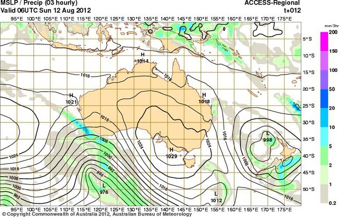
Forecast chart for 1600hr today - Telcoinaback Airlie Beach Race Week 2012 Kenn Batt
Telcoinabox Airlie Beach Race Week - Day 3 forecast: Nil Warnings current at time of writing for this area.
Synoptic Discussion: A large high over the Great Australia Bight [1033hPa] coupled with a complex low pressure system [997hPa] over the southern Tasman Sea, is extending a firm ridge along the Queensland coast.
Observations:
At 0600hr Hamilton Island was reporting the following conditions:
Wind 170deg at 13kn (ave) gusting to 16kn, Temp 16C, Pressure 1020hPa).
Forecast Winds for Middle of Pioneer Bay (Read Discussion below)
1000:MD150 DR(170-130) MS14 SR08-19kn
1200:MD140 DR(160-120) MS10 SR06-16kn could be light and variable?
1400:MD125 DR(145-105) MS10 SR06-16kn
1600:MD100 DR(120-080) MS12 SR06-17kn
1800:MD090 DR(110-070) MS12 SR06-17kn
Note: Direction trending 20-30deg more left than above closer to coast after about 1100hr.
Whitsunday Passage and Molle Channel: Wind speeds 2 to 3kn stronger in places at times than those above first up this morning, before easing mid-late morning. Localised patchy winds possible late morning and early afternoon. Winds could be gusty and erratic around some headlands and in more constrained locations.
Note: First column is mean wind direction in deg Magnetic (MD). It is the 10min average (mean) value at a height of 10m above the water leading up to the hour quoted. The second column is the directional range (DR) of the wind direction in deg Mag. This takes into account the natural oscillation of the wind and is a function of the atmospheric stability, etc. The third column is the mean speed (MS) in knots (kn) and is the average 10min value leading up to the hour quoted at a height of 10m above the water. The last column is the wind speed range (SR) in knots and is the lowest wind speed to highest wind speed in the 10min leading up to forecast hour.
Discussion: A ridge of high pressure lies along the Q’ld coast. Like yesterday, a bubble high and thus slacker pressure gradient, is expected to form over the general area during the afternoon (see forecast chart valid for 1600hr today). This situation (like yesterday) should see the SE winds ease during the morning, becoming patchy in places, trending more left under the influence of the sea breeze component during the afternoon.
Other possibilities: 45% chance that there is a 'glassout’ this morning followed by an E-NE sea breeze at 6-13kn (ave)?
10% chance that bubble high doesn’t form. If this occurs then winds would hang in from 140-120deg at 14-22kn (ave) and 3-5kn stronger in the Whitsunday Passage and Molle Channel at times.
Note: Wind will be lighter in the lee of any landmass and stronger and more gusty between islands (in channels and passages) and around some headlands.
Natural oscillations today around 15 to 25 deg away from effects of topography, tending 30 to 50 deg closer to the effects of any land mass (including islands and headlands).
Weather: Cool at first. A dry and sunny day. Maximum land temperature at Airlie Beach: about 21 degrees.
Wind Waves: 0.4 to 1.2 metres. Less in lee of land, more when wind wave opposes tidal current and further offshore. (Wave heights quoted are significant wave heights).
Tide at Shute Harbour: High of 2.31m at 0728hr, Low of 0.81m at 1316hr and High of 3.19m at 1957hr.
Tidal Stream: A good ebb this morning becoming slack before a strong flood later this afternoon. Be very careful particularly in passages, channels, close to islands, etc.
Remember: Tidal currents generally flood to the south and ebb to the north in the Whitsundays (with a multitude of local effects and eddies. So be prepared!).
Sea Temperature: about 20 degrees.
Outlook, Tuesday: Mostly sunny. SE 14 to 22 kn Airlie Beach Race Week website
If you want to link to this article then please use this URL: www.sail-world.com/100894