Audi Hamilton Island Race Week day 3 weather
by Kenn Batt on 20 Aug 2012
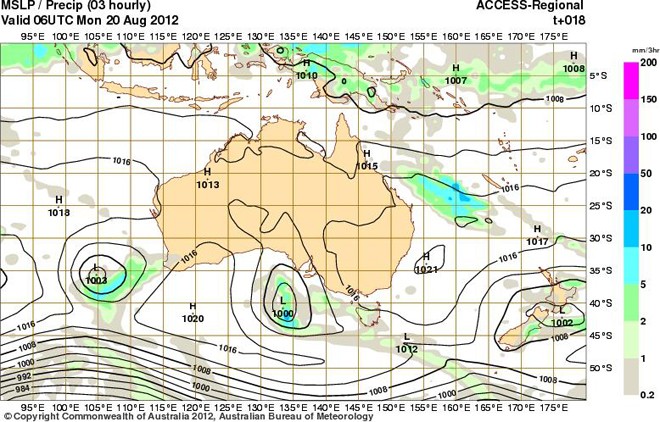
Forecast chart valid for 1600hr today SW
Latest weather from Kenn Batt:
Audi Hamilton Island Race Week day 3 forecast. Nil warnings current.
Synoptic situation: A high pressure system over New South Wales will move eastwards into the Tasman Sea today, maintaining a ridge over Queensland. The upper level trough that caused the rain yesterday and overnight, will move eastwards and away from the east Queensland coast today. A trough will deepen in the central Coral Sea but is expected to move eastwards.
Observations: At 0700hr
Hamilton Island: 130deg at 16kn (ave) gusting to 19kn, 17C 1020hPa
Hardy Reef: 140deg at 17kn (ave) gusting to 24kn
Rain showing on the weather radar in the general area, moving from NW.
Forecast winds for Surprise Rock (not including effects of topography and precipitation):
0900: MD: 140 DirR 150-110 MS 15kn SpR 11-20kn
1200: MD: 130 DirR 150-110 MS 13kn SpR 09-18kn
1500: MD: 120 DirR 140-100 MS 13kn SpR 09-18kn sea breeze component from here?
1700: MD: 120 DirR 140-100 MS 12kn SpR 08-17kn
Key: MD=mean direction degM DirR=possible directional range degM in the 10min period leading up to hour MS=mean wind speed in knots (kn) in 10min leading up to hour SpR= possible wind speed range in kn (lowest to highest) in the 10min leading up to the hour.
Note that there is a multitude of local effects in the Whitsunday area generally and the winds forecast above will have to be massaged accordingly.
Discussion: Forecast confidence= Average. Natural wind oscillations: about 10-20deg away from the effects of the land.
The wind didn’t build to expected range yesterday due to the surge being not as strong as predicted. At least we got the forecast rain!!
High pressure ridge over area.
With the upper trough moving eastwards and off the coast this morning, the bulk of the middle level cloud and rain should clear this morning. With sunshine expected today, the surface winds should trend left a little from about 1500hr due to the sea breeze component?
Other possibilities: 55% chance that wind speeds are about 2-3kn stronger than those forecast above, particularly this morning?
30% chance that wind direction reaches max left of 090deg after 1500hr?
Weather: Rain clearing this morning to a fine afternoon with some sunshine. Maximum temperature on Hamilton Island: about 21deg
Wind Waves: 0.5 to 1.2 metres (significant wave height). Note that waves can be higher when tidal current opposes wind wave and waves can be less in height in the lee of land and lighter than forecast winds.
Tide at Shute Harbour: Low of 0.54 m at 0607hr, High of 2.93m at 1221hr and Low of 0.67m at 1809hr.
Tidal Current: a strong flood this morning to a strong ebb this afternoon via a slack period. Great care required in Channels and Passages and anywhere else!
Outlook for Tuesday: Chance of a shower. E-SE at 12-16kn (ave)
If you want to link to this article then please use this URL: www.sail-world.com/101130