Audi Hamilton Island Race Week Weather Forecast
by Kenn Batt on 18 Aug 2013
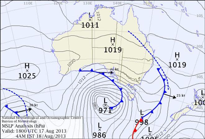
Latest surface chart - Audi Hamilton Island Race Week 2013 SW
Audi Hamilton Island Race Week weather forecast issued by Kenn Batt at 07150hr for Sunday 18th August 2013.
Nil Warnings current.
Synoptic Discussion:
A weak high [1019 hPa] over the southern Coral Sea is expected to move slowly eastwards, maintaining a weak ridge onto the tropical east coast of Queensland during today. A trough of low pressure lies over central Queensland.
Observations:
At 0700hr the surface wind at Hamilton Island was 260 deg at 3kn, gusting 4kn (temp 20C, pressure 1018hPa). At Hardy Reef (further offshore at 19.7S 149.2E) the wind was 040deg at 6kn.
Forecast Winds for a point 1.5nm NW of Henning Island (Read Discussion below)
1000:MD020 DR(350-040) MS03 SR01-07kn could be more variable?
1200:MD090 DR(070-110) MS08 SR04-12kn could be more variable?
1400:MD090 DR(060-110) MS10 SR05-14kn
1600:MD080 DR(050-100) MS10 SR05-15kn
1800:MD060 DR(020-080) MS09 SR04-13kn
Key: First column is mean wind direction in deg Magnetic (MD). It is the 10min average (mean) value at a height of 10m above the water leading up to the hour quoted. The second column is the directional range (DR) of the wind direction in deg Mag. This takes into account the natural oscillation of the wind and is a function of the atmospheric stability, etc. The third column is the mean speed (MS) in knots (kn) and is the average 10min value leading up to the hour quoted at a height of 10m above the water. The last column is the wind speed range (SR) in knots and is the lowest wind speed to highest wind speed in the 10min leading up to forecast hour.
Discussion
All models are pointing towards light and variable winds first up tending to a sea breeze this afternoon.
The forecast gradient wind (wind at 900 metres) commences as an 8kn northerly becoming light and variable this afternoon. This scenario normally favours a pure sea breeze situation.
Wind direction and speed is expected to become more variable than forecast above over most parts of the race course due to changing topographical profiles i.e. wind speed enhancement (+3kn or so) due to funneling out of bays to the east of the race course, some speed enhancement and wind directional changes around headlands and in passages. Lighter and more variable winds in the lee of islands, etc
Natural wind direction oscillations: around 20 to 30 deg, more/less due to topographical influences.
Weather
Early low cloud clearing to a mostly sunny day.
Maximum land temperature at Hamilton Island: 24 degrees.
Sea Temperature: about 21-22 degrees.
Wind Waves:
0.2 to 0.8 metres, less in lee of land, more when wind wave opposes tidal current.
(Wave heights quoted are Significant wave heights).
Current: A strong ebb this morning followed by slack water and then a strong flood developing later this afternoon/evening. Be extremely careful in channels, etc.
Remember: In general tidal currents flood to the south and ebb to the north in the Whitsundays. There are many localized variations however so be very vigilant.
Tide at Shute Harbour: High of 2.83 at 0820hr, Low 0.20m at 1410hr and High 3.91m at 2055hr.
Outlook
Monday: Similar to today.
Tuesday: N to NW winds at 8 to 14 kn (ave), shifting SW to SE at 12 to 18 kn (ave) during the afternoon.
Wednesday: S to SE at 15 to 24kn (ave). Cooler with the chance of a shower.
Thursday: SE at 14 to 18kn (ave). Partly cloudy.
Friday: SE to E at 10 to 14kn (ave). Mostly sunny.
Saturday: S-SE at 15 to 20kn (ave). Chance of a shower.
If you want to link to this article then please use this URL: www.sail-world.com/113320